
파일:Tabaqah assad.jpg
미리 보기 크기: 592 × 600 픽셀 다른 해상도: 237 × 240 픽셀 | 631 × 639 픽셀
원본 파일 (631 × 639 픽셀, 파일 크기: 236 KB, MIME 종류: image/jpeg)
파일 설명
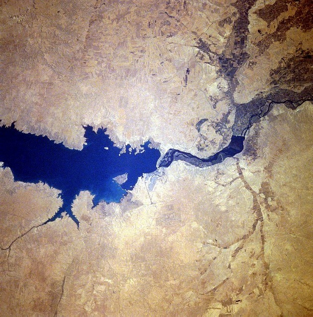
| 설명 |
سد الفرات وبحيرة الأسد من الفضاء كانون الثاني 1996 English: Completed in 1973, the Tabaqah Dam (center of image) on the Euphrates River can be seen in this near-nadir view. The Tabaqah Dam is an earth filled dam nearly 197 feet (60 meters) high and 3 miles (5 km) long. The dam holds the waters of Lake Assad (center to left center of the image), a 50-mile (80 km) long and 5-mile (8 km) wide reservoir. Lake Assad and the Tabaqah Dam have not only provided increased hydroelectric power but the lake has doubled Syria’s irrigated land. Actual crop production has not reached the goals set by the Syrian government due to a number of problems including the gypsum subsoil of the region, and whether or not farmers could be attracted back to this scarsely populated area from urban areas or more crowded agricultural areas in other parts of the country. Also the water levels within Lake Assad remain low due mostly in part to construction of the Keban and Ataturk Dams in Turkey, which have reduced the water flow of the Euphrates River in Syria. |
| 날짜 | |
| 출처 | http://eol.jsc.nasa.gov/sseop/EFS/photoinfo.pl?PHOTO=STS078-740-83 , http://upload.wikimedia.org/wikipedia/en/c/cf/Tabaqah_assad.jpg |
| 저자 | NASA |
This image or video was catalogued by one of the centers of the United States National Aeronautics and Space Administration (NASA) under Photo ID: STS078-740-83. This tag does not indicate the copyright status of the attached work. A normal copyright tag is still required. See Commons:Licensing. Other languages:
|
라이선스
| 이 파일은 NASA에서 제작하였으므로 퍼블릭 도메인입니다. NASA의 저작권 정책에 따르면 NASA의 자료는 명시하지 않는 이상 저작권의 보호를 받지 않습니다. (Template:PD-USGov, 또는 NASA 저작권 정책 문서, JPL 그림 사용 정책을 참고하세요.) | ||
 |
주의사항:
|
파일 역사
날짜/시간 링크를 클릭하면 해당 시간의 파일을 볼 수 있습니다.
| 날짜/시간 | 섬네일 | 크기 | 사용자 | 설명 | |
|---|---|---|---|---|---|
| 현재 | 2010년 2월 3일 (수) 17:45 | | 631 × 639 (236 KB) | Rehman | Flipped to align according to directions |
| 2007년 10월 29일 (월) 06:09 |  | 631 × 639 (200 KB) | Amir syria | {{Information |Description=سد الفرات |Source=http://eol.jsc.nasa.gov/sseop/EFS/photoinfo.pl?PHOTO=STS078-740-83 , http://upload.wikimedia.org/wikipedia/en/c/cf/Tabaqah_assad.jpg |Date= |Author= |Permission= |other_versions= }} |
이 파일을 사용하는 문서
다음 문서 1개가 이 파일을 사용하고 있습니다:
이 파일을 사용하고 있는 모든 위키의 문서 목록
다음 위키에서 이 파일을 사용하고 있습니다:
- ar.wikipedia.org에서 이 파일을 사용하고 있는 문서 목록
- arz.wikipedia.org에서 이 파일을 사용하고 있는 문서 목록
- be.wikipedia.org에서 이 파일을 사용하고 있는 문서 목록
- bn.wikipedia.org에서 이 파일을 사용하고 있는 문서 목록
- ca.wikipedia.org에서 이 파일을 사용하고 있는 문서 목록
- ceb.wikipedia.org에서 이 파일을 사용하고 있는 문서 목록
- de.wikipedia.org에서 이 파일을 사용하고 있는 문서 목록
- en.wikipedia.org에서 이 파일을 사용하고 있는 문서 목록
- es.wikipedia.org에서 이 파일을 사용하고 있는 문서 목록
- fa.wikipedia.org에서 이 파일을 사용하고 있는 문서 목록
- fr.wikipedia.org에서 이 파일을 사용하고 있는 문서 목록
- he.wikipedia.org에서 이 파일을 사용하고 있는 문서 목록
- hy.wikipedia.org에서 이 파일을 사용하고 있는 문서 목록
- id.wikipedia.org에서 이 파일을 사용하고 있는 문서 목록
- it.wikipedia.org에서 이 파일을 사용하고 있는 문서 목록
- lt.wikipedia.org에서 이 파일을 사용하고 있는 문서 목록
- nl.wikipedia.org에서 이 파일을 사용하고 있는 문서 목록
- nn.wikipedia.org에서 이 파일을 사용하고 있는 문서 목록
- no.wikipedia.org에서 이 파일을 사용하고 있는 문서 목록
- pl.wikipedia.org에서 이 파일을 사용하고 있는 문서 목록
- pt.wikipedia.org에서 이 파일을 사용하고 있는 문서 목록
- ro.wikipedia.org에서 이 파일을 사용하고 있는 문서 목록
- ru.wikipedia.org에서 이 파일을 사용하고 있는 문서 목록
- sv.wikipedia.org에서 이 파일을 사용하고 있는 문서 목록
이 파일의 더 많은 사용 내역을 봅니다.