
파일:Vicente 2005-09-16 0550Z.jpg

미리 보기 크기: 480 × 600 픽셀 다른 해상도: 192 × 240 픽셀 | 384 × 480 픽셀 | 614 × 768 픽셀 | 819 × 1,024 픽셀 | 1,638 × 2,048 픽셀 | 6,400 × 8,000 픽셀
원본 파일 (6,400 × 8,000 픽셀, 파일 크기: 6.8 MB, MIME 종류: image/jpeg)
파일 설명
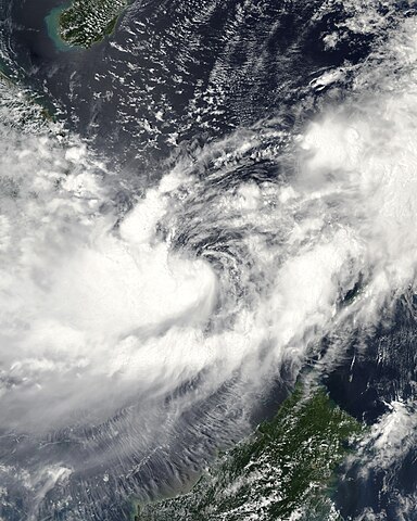
| 설명 | This image of Tropical Storm Vicente was captured by the MODIS instrument on NASA's Aqua satellite at 0546 UTC when it was located in the South China Sea. The maximum sustained winds for the storm were 30 knots (10-minute average) and the minimum pressure was about 1000 mb. | ||||||
| 날짜 | |||||||
| 출처 | http://www.nrlmry.navy.mil/tc_pages/tc_home.html | ||||||
| 저자 | Naval Research Laboratory | ||||||
| 저작권 (이 파일을 인용하기) |
|
||||||

파일 역사
날짜/시간 링크를 클릭하면 해당 시간의 파일을 볼 수 있습니다.
| 날짜/시간 | 섬네일 | 크기 | 사용자 | 설명 | |
|---|---|---|---|---|---|
| 현재 | 2020년 9월 30일 (수) 00:55 | | 6,400 × 8,000 (6.8 MB) | FleurDeOdile | dimensions |
| 2017년 12월 13일 (수) 13:26 |  | 6,706 × 6,562 (3.98 MB) | TheAustinMan | Color and grid-less | |
| 2006년 9월 15일 (금) 01:56 |  | 3,875 × 3,875 (1.63 MB) | Good kitty | == Summary == {{Information |Description=This image of Tropical Storm Vicente was captured by the MODIS instrument on NASA's Aqua satellite at 0546 UTC when it was located in the South China Sea. The maximum sustained winds for the storm were 30 knots (10 |
이 파일을 사용하는 문서
다음 문서 1개가 이 파일을 사용하고 있습니다:
이 파일을 사용하고 있는 모든 위키의 문서 목록
다음 위키에서 이 파일을 사용하고 있습니다:
- en.wikipedia.org에서 이 파일을 사용하고 있는 문서 목록
- es.wikipedia.org에서 이 파일을 사용하고 있는 문서 목록
- ja.wikipedia.org에서 이 파일을 사용하고 있는 문서 목록
- pt.wikipedia.org에서 이 파일을 사용하고 있는 문서 목록
- vi.wikipedia.org에서 이 파일을 사용하고 있는 문서 목록
- zh.wikipedia.org에서 이 파일을 사용하고 있는 문서 목록