
파일:Satellite image of New Zealand in December 2002.jpg
미리 보기 크기: 455 × 600 픽셀 다른 해상도: 182 × 240 픽셀 | 364 × 480 픽셀 | 582 × 768 픽셀 | 777 × 1,024 픽셀 | 1,554 × 2,048 픽셀 | 4,400 × 5,800 픽셀
원본 파일 (4,400 × 5,800 픽셀, 파일 크기: 3.39 MB, MIME 종류: image/jpeg)
| 설명 |
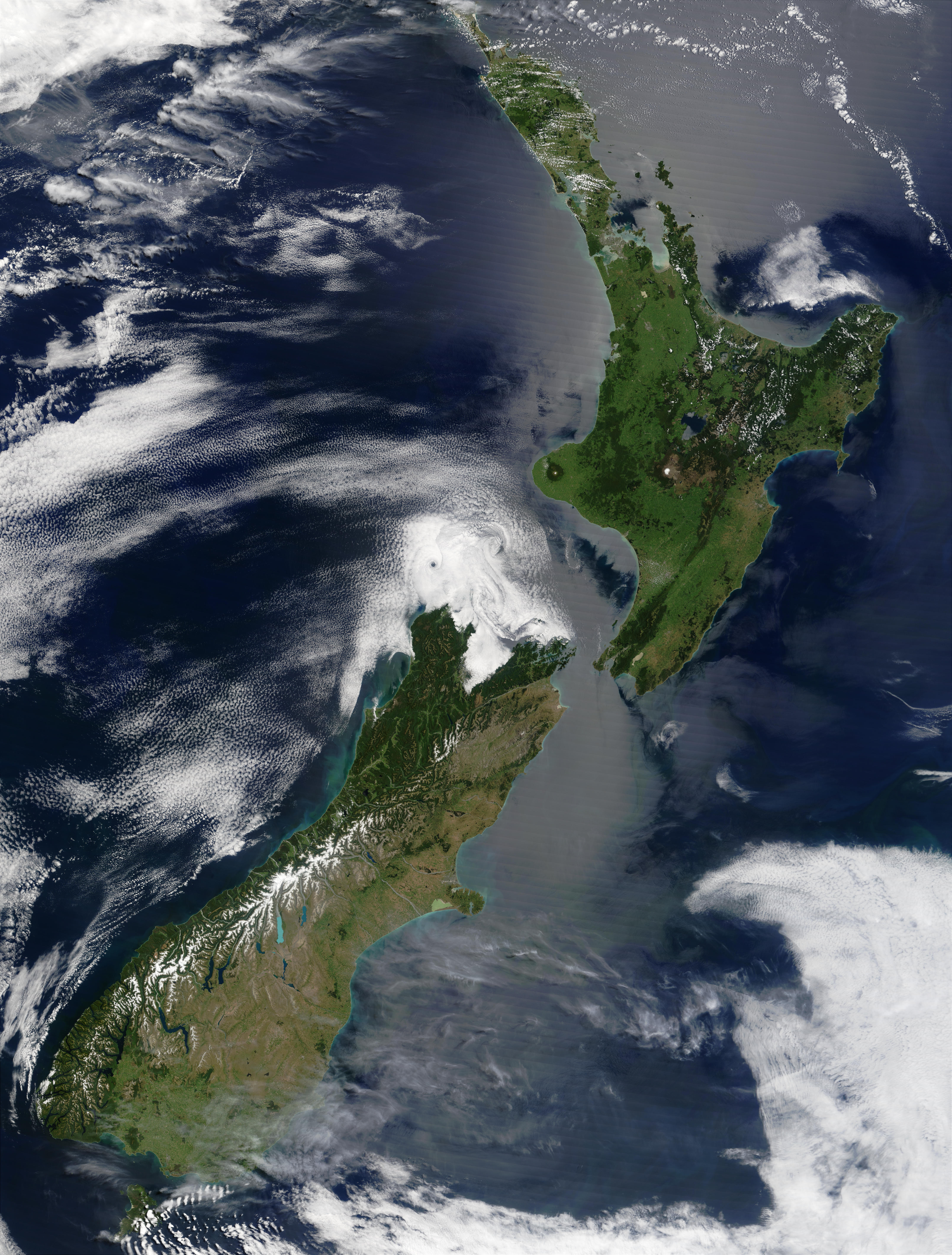
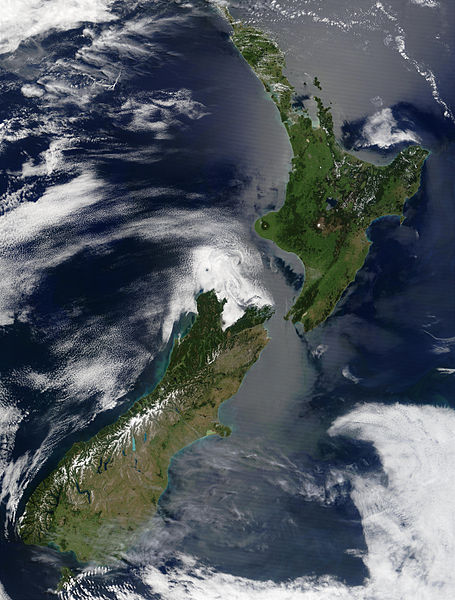
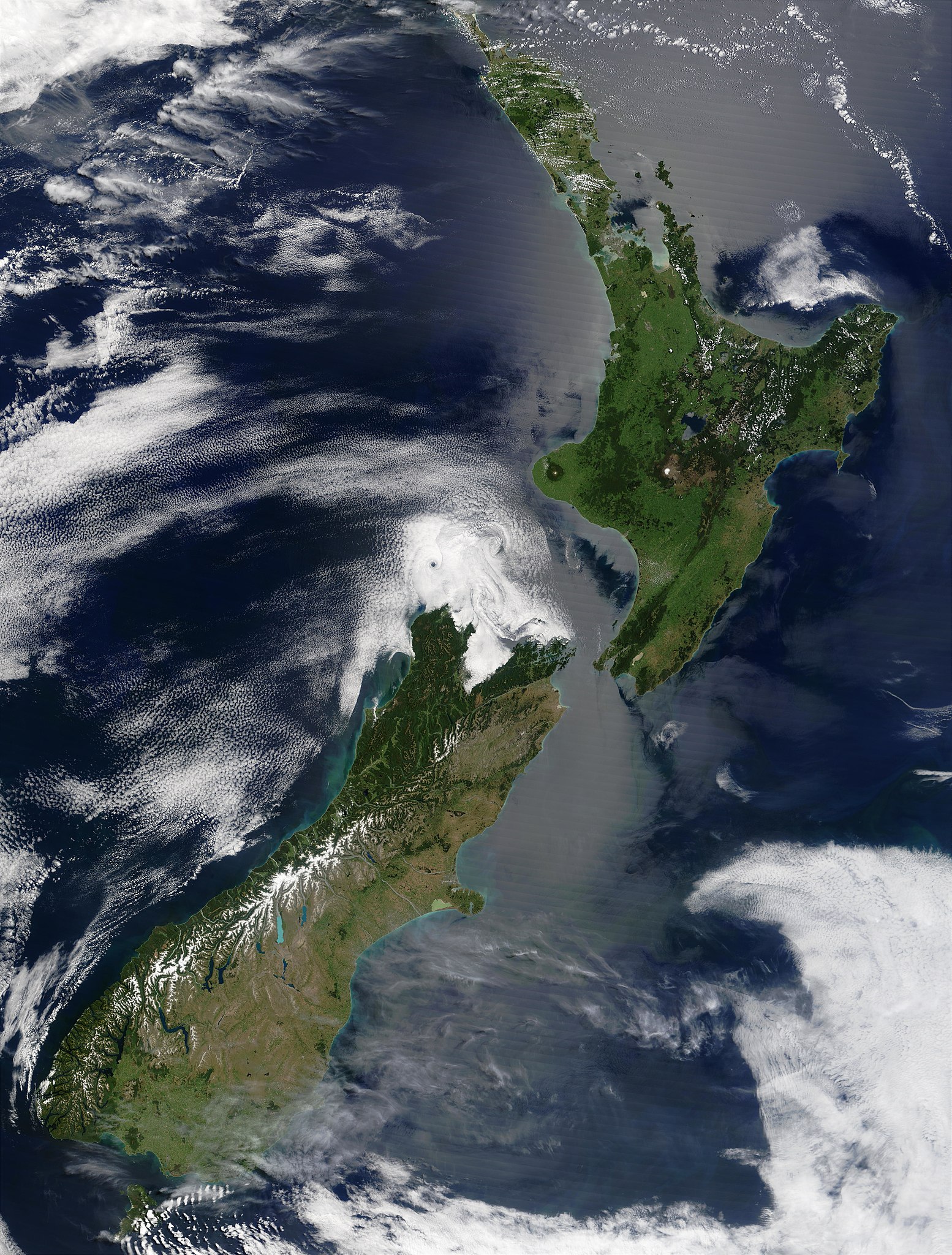
English: Satellite image of New Zealand in December 2002. NASA's description:
|
| 날짜 | |
| 출처 | Taken from NASA's Visible Earth: [1] |
| 저자 | Jacques Descloitres, MODIS Land Rapid Response Team at NASA GSFC |
이 이미지는 2005년 9월 12일의 오늘의 이미지로 선정되었습니다. 이미지 설명은 다음과 같습니다. English: Satellite image of New Zealand in December 2002. 다른 언어들:
Brezhoneg : Skeudenn dre loarell eus Zeland-Nevez e Kerzu 2002. Čeština: Satelitní snímek Nového Zélandu z prosince 2002 Cymraeg: Delwedd lloeren o Seland Newydd, yn Rhagfyr 2002. Dansk: Satellitbillede af New Zealand fra december 2002. Deutsch: Satellitenbild von Neuseeland in Dezember 2002 English: Satellite image of New Zealand in December 2002. Español: Imagen de satélite de Nueva Zelanda en diciembre de 2002 Français : La Nouvelle-Zélande en décembre 2002, vue de l'espace Galego: Imaxe de satélite de Nova Zelanda en decembro de 2002. Latina: Photographema satellitium Novae Zelandiae, Decembre 2002 Nederlands: Satelliet foto van Nieuw-Zeeland in december 2002. Norsk nynorsk: Satelittbilde av New Zealand frå desember 2002. Polski: Satelitarny obraz Nowej Zelandii w grudniu 2002 Português: Imagem satélite da Nova Zelândia em Dezembro de 2002. Slovenčina: Satelitný záber na Nový Zéland z decembra 2002 Suomi: Uusi Seelanti satelliittikuvassa joulukuussa 2002. Русский: Спутниковый снимок Новой Зеландии в декабре 2002. ไทย: ภาพถ่ายดาวเทียมประเทศนิวซีแลนด์เมื่อเดือนธันวาคม พ.ศ. ๒๕๔๕ 日本語: 2002年12月のニュージーランドの衛星写真 |
| 이 파일은 NASA에서 제작하였으므로 퍼블릭 도메인입니다. NASA의 저작권 정책에 따르면 NASA의 자료는 명시하지 않는 이상 저작권의 보호를 받지 않습니다. (Template:PD-USGov, 또는 NASA 저작권 정책 문서, JPL 그림 사용 정책을 참고하세요.) | ||
 |
주의사항:
|
파일 역사
날짜/시간 링크를 클릭하면 해당 시간의 파일을 볼 수 있습니다.
| 날짜/시간 | 섬네일 | 크기 | 사용자 | 설명 | |
|---|---|---|---|---|---|
| 현재 | 2005년 5월 4일 (수) 00:51 | | 4,400 × 5,800 (3.39 MB) | Hautala | {{PD-USGov-NASA}} Satellite image of New Zealand in December 2002. NASA's description: :These stunning true-color images provide a rare, cloud-free look at the island nation of New Zealand, including most of its North and South Islands. This scene was ac |
이 파일을 사용하는 문서
다음 문서 1개가 이 파일을 사용하고 있습니다:
이 파일을 사용하고 있는 모든 위키의 문서 목록
다음 위키에서 이 파일을 사용하고 있습니다:
- ckb.wikipedia.org에서 이 파일을 사용하고 있는 문서 목록
- en.wikipedia.org에서 이 파일을 사용하고 있는 문서 목록
- eo.wikipedia.org에서 이 파일을 사용하고 있는 문서 목록
- es.wikipedia.org에서 이 파일을 사용하고 있는 문서 목록
- frp.wikipedia.org에서 이 파일을 사용하고 있는 문서 목록
- fr.wikipedia.org에서 이 파일을 사용하고 있는 문서 목록
- got.wikipedia.org에서 이 파일을 사용하고 있는 문서 목록
- hu.wikipedia.org에서 이 파일을 사용하고 있는 문서 목록
- hy.wikipedia.org에서 이 파일을 사용하고 있는 문서 목록
- ia.wikipedia.org에서 이 파일을 사용하고 있는 문서 목록
- is.wikipedia.org에서 이 파일을 사용하고 있는 문서 목록
- ja.wikipedia.org에서 이 파일을 사용하고 있는 문서 목록
- ja.wikinews.org에서 이 파일을 사용하고 있는 문서 목록
- ka.wikipedia.org에서 이 파일을 사용하고 있는 문서 목록
- nl.wikipedia.org에서 이 파일을 사용하고 있는 문서 목록
- pl.wikipedia.org에서 이 파일을 사용하고 있는 문서 목록
- pt.wikipedia.org에서 이 파일을 사용하고 있는 문서 목록
- ru.wikipedia.org에서 이 파일을 사용하고 있는 문서 목록
- ru.wikinews.org에서 이 파일을 사용하고 있는 문서 목록
- sl.wikipedia.org에서 이 파일을 사용하고 있는 문서 목록
- sw.wikipedia.org에서 이 파일을 사용하고 있는 문서 목록
- ta.wikinews.org에서 이 파일을 사용하고 있는 문서 목록
- tr.wikipedia.org에서 이 파일을 사용하고 있는 문서 목록
- vi.wikipedia.org에서 이 파일을 사용하고 있는 문서 목록
- zh.wikipedia.org에서 이 파일을 사용하고 있는 문서 목록