
파일:Satellite image of Madagascar in September 2003.jpg
미리 보기 크기: 312 × 598 픽셀 다른 해상도: 125 × 240 픽셀 | 250 × 480 픽셀 | 400 × 768 픽셀 | 534 × 1,024 픽셀 | 1,068 × 2,048 픽셀 | 3,214 × 6,164 픽셀
원본 파일 (3,214 × 6,164 픽셀, 파일 크기: 2.94 MB, MIME 종류: image/jpeg)
| 설명 |
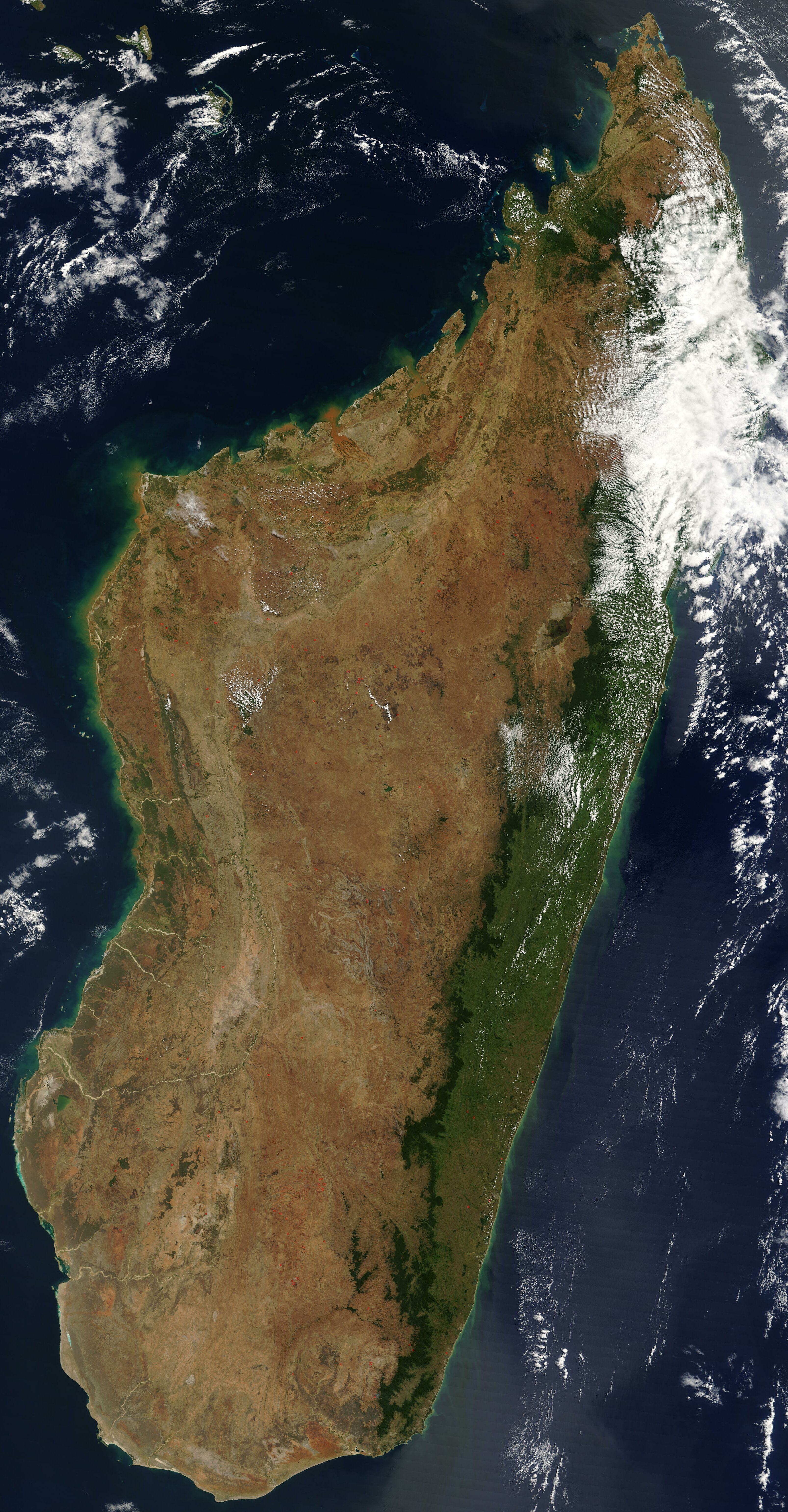
English: Satellite image of Madagascar in September 2003. Slightly cropped, original taken from NASA's Visible Earth: [1]. Original description:
|
| 날짜 | |
| 출처 | http://visibleearth.nasa.gov/view_rec.php?id=5769 |
| 저자 | 미상 |
이 이미지는 2005년 11월 1일의 오늘의 이미지로 선정되었습니다. 이미지 설명은 다음과 같습니다. English: Satellite image of Madagascar in September 다른 언어들:
Čeština: Pohled ze satelitu na Madagaskar (září 2003) Cymraeg: Delwedd lloeren o Madagascar (Medi 2003) Deutsch: Satellitenbild von Madagaskar English: Satellite image of Madagascar in September Español: Imagen satelital de Madagascar en septiembre Français : Image satellite de Madagascar (septembre 2003) Gaeilge: Radharc Madagascar ó spás. Italiano: Immagine satellitare dell'isola di Madagascar Latina: Madagascariae imago satellitia Nederlands: Sattellietfoto van Madagaskar in september. Norsk bokmål: Satellittbilde av Madagaskar. Norsk nynorsk: Satellittbilde av Madagaskar. Polski: Satelitarny obraz Madagaskaru (wrzesień 2003) Slovenčina: Satelitná snímka Madagaskaru (spetember 2003) Suomi: Syyskuinen Madagaskar satelliittikuvassa Svenska: Satellitbild av Madagaskar. Русский: Спутниковая фотография Мадагаскара, четвёртого по величине острова в мире, сделанная 10 сентября 2003 года. ไทย: ภาพถ่ายดาวเทียมเกาะมาดากัสการ์เมื่อเดือนกันยายน พ.ศ. ๒๕๔๖ 中文: 2003年9月马达加斯加的卫星照片 |
| 이 파일은 NASA에서 제작하였으므로 퍼블릭 도메인입니다. NASA의 저작권 정책에 따르면 NASA의 자료는 명시하지 않는 이상 저작권의 보호를 받지 않습니다. (Template:PD-USGov, 또는 NASA 저작권 정책 문서, JPL 그림 사용 정책을 참고하세요.) | ||
 |
주의사항:
|
파일 역사
날짜/시간 링크를 클릭하면 해당 시간의 파일을 볼 수 있습니다.
| 날짜/시간 | 섬네일 | 크기 | 사용자 | 설명 | |
|---|---|---|---|---|---|
| 현재 | 2005년 1월 7일 (금) 21:51 | | 3,214 × 6,164 (2.94 MB) | Hautala | {{PD-USGov-NASA}} Satellite image of Madagascar in September 2003. Slightly cropped, original taken from NASA's Visible Earth http://visibleearth.nasa.gov/cgi-bin/viewrecord?25841 . Original description: The world’s fourth largest island, Madagasca |
이 파일을 사용하는 문서
다음 문서 3개가 이 파일을 사용하고 있습니다:
이 파일을 사용하고 있는 모든 위키의 문서 목록
다음 위키에서 이 파일을 사용하고 있습니다:
- af.wikipedia.org에서 이 파일을 사용하고 있는 문서 목록
- arz.wikipedia.org에서 이 파일을 사용하고 있는 문서 목록
- ast.wikipedia.org에서 이 파일을 사용하고 있는 문서 목록
- az.wikipedia.org에서 이 파일을 사용하고 있는 문서 목록
- ba.wikipedia.org에서 이 파일을 사용하고 있는 문서 목록
- be-tarask.wikipedia.org에서 이 파일을 사용하고 있는 문서 목록
- br.wikipedia.org에서 이 파일을 사용하고 있는 문서 목록
- ca.wikipedia.org에서 이 파일을 사용하고 있는 문서 목록
- ce.wikipedia.org에서 이 파일을 사용하고 있는 문서 목록
- ckb.wikipedia.org에서 이 파일을 사용하고 있는 문서 목록
- cs.wikipedia.org에서 이 파일을 사용하고 있는 문서 목록
- cv.wikipedia.org에서 이 파일을 사용하고 있는 문서 목록
- cy.wikipedia.org에서 이 파일을 사용하고 있는 문서 목록
- dag.wikipedia.org에서 이 파일을 사용하고 있는 문서 목록
- da.wikipedia.org에서 이 파일을 사용하고 있는 문서 목록
- de.wikivoyage.org에서 이 파일을 사용하고 있는 문서 목록
- diq.wikipedia.org에서 이 파일을 사용하고 있는 문서 목록
- en.wikipedia.org에서 이 파일을 사용하고 있는 문서 목록
- eo.wikipedia.org에서 이 파일을 사용하고 있는 문서 목록
- eo.wiktionary.org에서 이 파일을 사용하고 있는 문서 목록
- es.wikipedia.org에서 이 파일을 사용하고 있는 문서 목록
- et.wikipedia.org에서 이 파일을 사용하고 있는 문서 목록
- fa.wikipedia.org에서 이 파일을 사용하고 있는 문서 목록
- fi.wikipedia.org에서 이 파일을 사용하고 있는 문서 목록
- fi.wiktionary.org에서 이 파일을 사용하고 있는 문서 목록
- fr.wikipedia.org에서 이 파일을 사용하고 있는 문서 목록
- fr.wikivoyage.org에서 이 파일을 사용하고 있는 문서 목록
- ga.wikipedia.org에서 이 파일을 사용하고 있는 문서 목록
- gl.wikipedia.org에서 이 파일을 사용하고 있는 문서 목록
- gpe.wikipedia.org에서 이 파일을 사용하고 있는 문서 목록
- ha.wikipedia.org에서 이 파일을 사용하고 있는 문서 목록
- he.wikipedia.org에서 이 파일을 사용하고 있는 문서 목록
- ht.wikipedia.org에서 이 파일을 사용하고 있는 문서 목록
- hy.wikipedia.org에서 이 파일을 사용하고 있는 문서 목록
- ia.wikipedia.org에서 이 파일을 사용하고 있는 문서 목록
이 파일의 더 많은 사용 내역을 봅니다.