
파일:Sarajevo Grbavica.JPG
원본 파일 (2,900 × 1,860 픽셀, 파일 크기: 3.9 MB, MIME 종류: image/jpeg)
파일 설명
| 설명 |
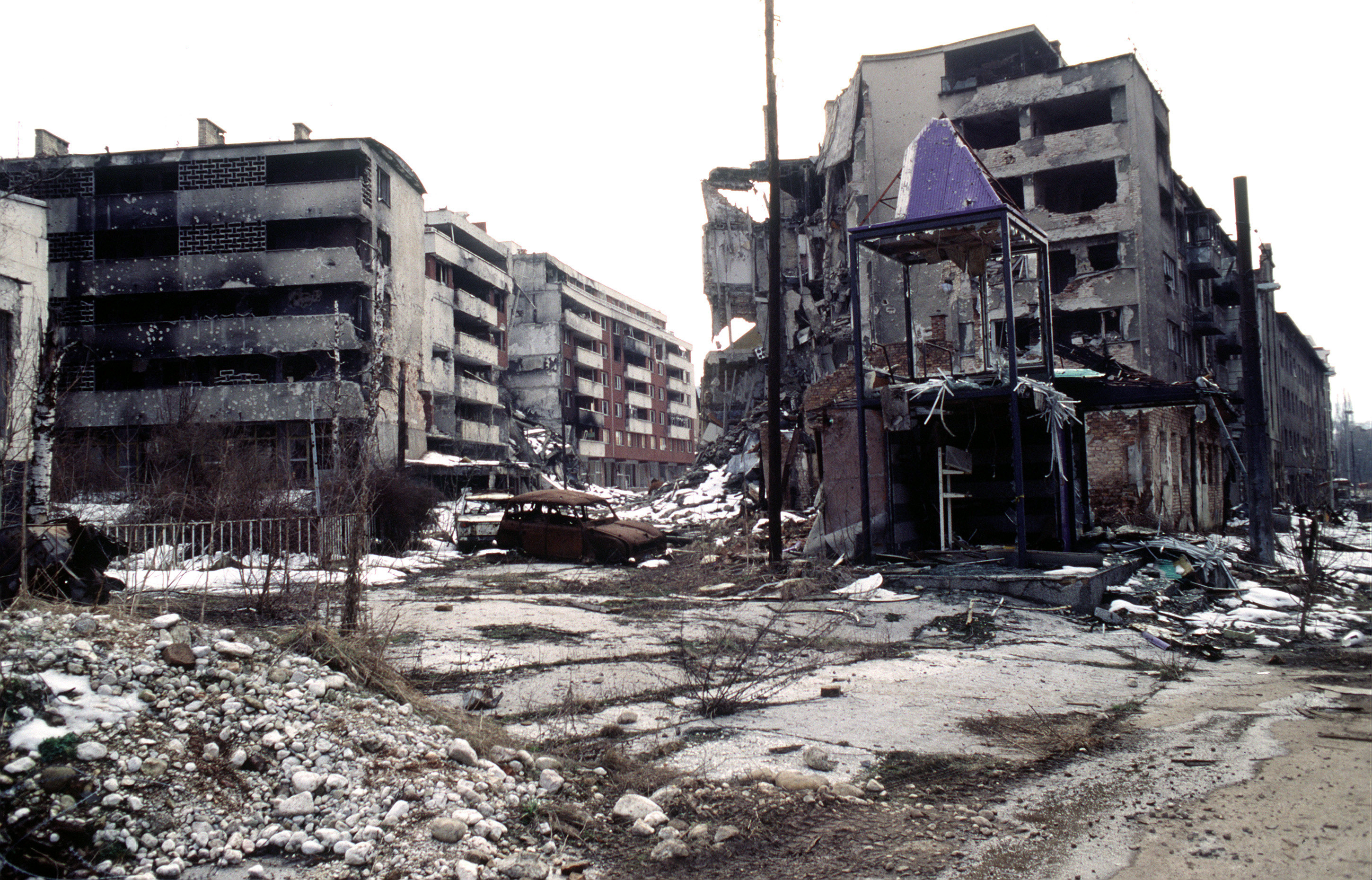
View of Grbavica, a neighbourhood of Sarajevo, approximately 4 months after the signing of the Dayton Peace Accord that officially ended the war in Bosnia. This particular scene shows the part of the neighbourhood located by the left bank of Miljacka river near Vrbanja bridge at the point where Zagrebačka Street and Beogradska Street (later renamed Emerika Bluma Street) meet. Throughout the war (1992-1995), Grbavica was held by the forces of Bosnian Serbs. In relation to the part of Grbavica shown in the photo, Bosnian Muslim (Bosniak) lines were right across on the Miljacka river's right bank. Due to its location in the crossfire between two sides, this part of Grbavica was exposed to constant fire and as a result suffered heavy structural damage. It was basically uninhabitable throughout the war - most of the apartments in the buildings seen in the photo were empty during the war as their occupants fled early on fearing for their safety. These ruins of the apartments and houses were among the last group to be turned over by the Bosnian Serbs to the Bosniaks (a.k.a. Bosnian Muslims) as required by the Dayton Peace Accord, which produced a lasting cease fire and permanent internal borders between two entities - Republika Srpska (Serb entity) and Federation of Bosnia-Herzegovina (Muslim-Croat entity). The white building whose small part (corner) can be seen along the photo's left edge housed the state-owned Unioninvest company before the war. In the years after the war ended, the partially devastated building was rebuilt and to this day houses the Office of the High Representative (OHR), an ad hoc international institution responsible for overseeing implementation of the Dayton Peace Accord (in essence, OHR is Bosnia's highest decision-making institutional body with broad powers). |
| 날짜 | |
| 출처 | www.dodmedia.osd.mil |
| 저자 | LT. STACEY WYZKOWSKI |
| 저작권 (이 파일을 인용하기) |
Public Domain (PD-USGov-Military) |
| 카메라 위치 | | 이 지역의 다른 사진을 보기: OpenStreetMap |
|---|
라이선스
이 파일은 미국군, 또는 국방부의 공무원이 직무상 작성한 미국 연방 정부의 저작물이므로 퍼블릭 도메인입니다.
자세한 정보는 http://www.defenselink.mil/multimedia/about.html 문서를 참고하세요.
|
 |
파일 역사
날짜/시간 링크를 클릭하면 해당 시간의 파일을 볼 수 있습니다.
| 날짜/시간 | 섬네일 | 크기 | 사용자 | 설명 | |
|---|---|---|---|---|---|
| 현재 | 2009년 4월 8일 (수) 06:02 | | 2,900 × 1,860 (3.9 MB) | PRODUCER | contrast |
| 2008년 3월 23일 (일) 23:37 |  | 2,900 × 1,860 (2.14 MB) | ¡0-8-15! | ||
| 2006년 11월 21일 (화) 07:00 |  | 640 × 410 (60 KB) | Bunker~commonswiki | == Summary == {{Information |Description=Overall view of downtown Grbavica, a suburb of Sarajevo. These apartments and houses once occupied by Bosnia Serbs are the last group to be turned over to the Muslims as required by the recent Dayton Peace Accord w |
이 파일을 사용하는 문서
이 파일을 사용하고 있는 모든 위키의 문서 목록
다음 위키에서 이 파일을 사용하고 있습니다:
- als.wikipedia.org에서 이 파일을 사용하고 있는 문서 목록
- ar.wikipedia.org에서 이 파일을 사용하고 있는 문서 목록
- azb.wikipedia.org에서 이 파일을 사용하고 있는 문서 목록
- be.wikipedia.org에서 이 파일을 사용하고 있는 문서 목록
- bg.wikipedia.org에서 이 파일을 사용하고 있는 문서 목록
- bs.wikipedia.org에서 이 파일을 사용하고 있는 문서 목록
- ca.wikipedia.org에서 이 파일을 사용하고 있는 문서 목록
- cs.wikipedia.org에서 이 파일을 사용하고 있는 문서 목록
- de.wikipedia.org에서 이 파일을 사용하고 있는 문서 목록
- el.wikipedia.org에서 이 파일을 사용하고 있는 문서 목록
- en.wikipedia.org에서 이 파일을 사용하고 있는 문서 목록
- en.wikinews.org에서 이 파일을 사용하고 있는 문서 목록
- en.wikiquote.org에서 이 파일을 사용하고 있는 문서 목록
- eo.wikipedia.org에서 이 파일을 사용하고 있는 문서 목록
- es.wikipedia.org에서 이 파일을 사용하고 있는 문서 목록
- eu.wikipedia.org에서 이 파일을 사용하고 있는 문서 목록
- fa.wikipedia.org에서 이 파일을 사용하고 있는 문서 목록
- fr.wikipedia.org에서 이 파일을 사용하고 있는 문서 목록
- he.wikipedia.org에서 이 파일을 사용하고 있는 문서 목록
- hr.wikipedia.org에서 이 파일을 사용하고 있는 문서 목록
- hu.wikipedia.org에서 이 파일을 사용하고 있는 문서 목록
- id.wikipedia.org에서 이 파일을 사용하고 있는 문서 목록
- it.wikipedia.org에서 이 파일을 사용하고 있는 문서 목록
이 파일의 더 많은 사용 내역을 봅니다.