
파일:San Francisco in ruin edit2.jpg

미리 보기 크기: 800 × 314 픽셀 다른 해상도: 320 × 126 픽셀 | 640 × 251 픽셀 | 1,024 × 402 픽셀 | 1,280 × 502 픽셀 | 2,560 × 1,005 픽셀 | 7,000 × 2,748 픽셀
원본 파일 (7,000 × 2,748 픽셀, 파일 크기: 4.32 MB, MIME 종류: image/jpeg)
파일 설명
|
| 설명 |
Deutsch: San Francisco in Ruinen am 28. Mai 1906, etwa 6 Wochen nach Erdbeben vom 18. April 1906 und Brand. Laut Kopierschablone aus 2000 Fuß (610 m) Höhe vom "Lawrence Captive Airship" fotografiert. Lawrence meinte damit eine Kette aus Drachen.
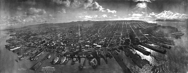
English: San Francisco lies in ruins on May 28, 1906, about six weeks after the 1906 San Francisco earthquake and fire. It was taken from a camera suspended on a kite, perhaps 1,000 feet above the city. It is one of the most well-known photographs of George R. Lawrence (see biography for more information about the technique used). The tower of the Ferry Building can be seen at the bay end of Market Street, which can be clearly seen all the way to the foothills of Twin Peaks. The water in the foreground is San Francisco Bay, with the Golden Gate to the right, rear. Note the absence of the Golden Gate Bridge and the San Francisco-Oakland Bay Bridge, which had yet to be constructed. Source information can be found on the description page of the original image. This is a version edited for the Featured Picture Candidates page.
Français : San Francisco en ruines le 28 mai 1906, six semaines après le Tremblement de terre du 18 avril 1906 et l'incendie qui a suivi. Photo prise à l'aide d'un cerf-volant, d'une altitude de 300 ou 400 mètres. Cette photo est la plus connue de George R. Lawrence. La tour du Ferry Building marque le début de Market Street, qui est visible sur toute sa longueur, jusqu'aux Twin Peaks. Au premier plan, on peut voir la Baie de San Francisco. A droite se trouve le Golden Gate. Les ponts du Golden gate et de la baie n'étaient pas encore construits à l'époque. Plus d'information sur la source est disponible dans la légende de l'image originale. |
||
| 날짜 | |||
| 출처 |
Panoramic photographs, Library of Congress, Reproduction number LC-DIG-ppmsca-07823 DLC
|
||
| 저자 | George R. Lawrence (1869-1938), George R. Lawrence Co. | ||
| 다른 버전 | Panoramic photographer Ron Klein, took a similar photograph from approximately the same point in space, 100 years later, using a self built camera very like a George Lawrence model, but because kites are no longer allowed to fly in this airspace, had to use a helicopter. | ||
| References | NPR https://www.npr.org/blogs/pictureshow/2014/01/15/260152557/before-drone-cameras-kite-cameras |

라이선스
This media file is in the public domain in the United States. This applies to U.S. works where the copyright has expired, often because its first publication occurred prior to January 1, 1929, and if not then due to lack of notice or renewal. See this page for further explanation.
|
 | |
 |
This image might not be in the public domain outside of the United States; this especially applies in the countries and areas that do not apply the rule of the shorter term for US works, such as Canada, Mainland China (not Hong Kong or Macao), Germany, Mexico, and Switzerland. The creator and year of publication are essential information and must be provided. See Wikipedia:Public domain and Wikipedia:Copyrights for more details.
|
Wikipedia upload log
(All user names refer to en.wikipedia)
Previously uploaded to en.wikipedia; description page is/was here. 2006-06-05 upload date by Janke at en.wikipedia
- 2006-06-05 23:37 Janke 7000×2748×8 (4530695 bytes) Temporary file, edit for FPC {{PD-old}}
Location
The exact location is the intersection the extensions of Market Street and John Street (between Jackson Street and Pacific Avenue).
파일 역사
날짜/시간 링크를 클릭하면 해당 시간의 파일을 볼 수 있습니다.
| 날짜/시간 | 섬네일 | 크기 | 사용자 | 설명 | |
|---|---|---|---|---|---|
| 현재 | 2007년 8월 29일 (수) 10:48 | 7,000 × 2,748 (4.32 MB) | Grook Da Oger | {{Information |Description=en:San Francisco lies in ruins on May 28, 1906, about six weeks after the en:1906 San Francisco earthquake and fire. It was taken from a camera suspended on a kite 2,000 feet above the city. It is one of the most well |
이 파일을 사용하는 문서
다음 문서 1개가 이 파일을 사용하고 있습니다:
이 파일을 사용하고 있는 모든 위키의 문서 목록
다음 위키에서 이 파일을 사용하고 있습니다:
- ca.wikipedia.org에서 이 파일을 사용하고 있는 문서 목록
- cs.wikipedia.org에서 이 파일을 사용하고 있는 문서 목록
- da.wikipedia.org에서 이 파일을 사용하고 있는 문서 목록
- de.wikipedia.org에서 이 파일을 사용하고 있는 문서 목록
- en.wikipedia.org에서 이 파일을 사용하고 있는 문서 목록
- Kite aerial photography
- Frederick Funston
- George R. Lawrence
- Wikipedia:Featured pictures thumbs/03
- Wikipedia:Picture of the day/August 2006
- Wikipedia:Featured picture candidates/June-2006
- Wikipedia:Featured picture candidates/San Francisco earthquake
- Wikipedia:Wikipedia Signpost/2006-06-12/Features and admins
- Wikipedia:Picture of the day/August 22, 2006
- Wikipedia:POTD/August 22, 2006
- Wikipedia:POTD column/August 22, 2006
- Wikipedia:POTD row/August 22, 2006
- User:Naufana/Images
- Portal talk:California
- Portal:History/Featured picture/April, 2007
- User talk:Brian0918/Archive 22
- Portal:History/Featured picture/2007
- Kite applications
- Wikipedia:Featured pictures/History/USA History
- Wikipedia:WikiProject Earthquakes
- 1906 San Francisco earthquake
- Wikipedia:WikiProject United States/Recognized content
- User:Iadmc/WP Earthquakes copy
- Wikipedia talk:Valued picture candidates/Archive 3
- Wikipedia:WikiProject United States/Quality content
- Portal:San Francisco Bay Area/Selected historical image/Archive
- Portal:San Francisco Bay Area/Selected historical image/4
- User:Mercurywoodrose/SFBA galleries
- Wikipedia:WikiProject United States/Featured pictures
- Wikipedia:Wikipedia Signpost/Single/2006-06-12
- es.wikipedia.org에서 이 파일을 사용하고 있는 문서 목록
- fa.wikipedia.org에서 이 파일을 사용하고 있는 문서 목록
- fr.wikipedia.org에서 이 파일을 사용하고 있는 문서 목록
- he.wikipedia.org에서 이 파일을 사용하고 있는 문서 목록
- it.wikipedia.org에서 이 파일을 사용하고 있는 문서 목록
- ja.wikipedia.org에서 이 파일을 사용하고 있는 문서 목록
- ka.wikipedia.org에서 이 파일을 사용하고 있는 문서 목록
이 파일의 더 많은 사용 내역을 봅니다.