
파일:Qing Empire circa 1820 EN.svg

SVG 파일의 PNG 형식의 미리보기 크기: 686 × 600 픽셀. 다른 해상도: 275 × 240 픽셀 | 549 × 480 픽셀 | 879 × 768 픽셀 | 1,172 × 1,024 픽셀 | 2,343 × 2,048 픽셀 | 849 × 742 픽셀
원본 파일 (SVG 파일, 실제 크기 849 × 742 픽셀, 파일 크기: 548 KB)

|
This file requires updating because: The island of Sumatra as depicted on the small globe in the lower left is colliding with Atlantis (Tuva?) and a peninsula unknown to modern geography is extending off the western coast of India. The eastern coast of Taiwan was never under the sovereignty of the Qing Empire. In doing so, you could add a timestamp to the file.
|
파일 설명
| 설명 |
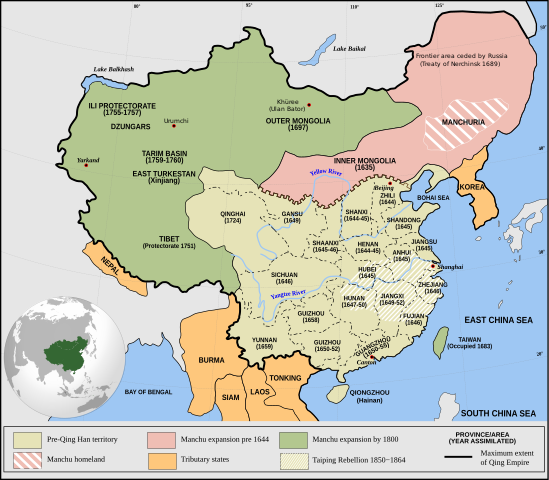
English: Qing Empire c. 1820 |
| 날짜 | |
| 출처 | 자작 Incorporates modified version of File:Empire of the Great Qing (orthographic projection).svg. Note that the map excludes Tawang from Tibet. |
| 저자 | Philg88: Attribution Wikimedia Foundation, www.wikimedia.org |
.svg)
라이선스
이 파일은 크리에이티브 커먼즈 저작자표시 4.0 국제 라이선스로 배포됩니다.
- 이용자는 다음의 권리를 갖습니다:
- 공유 및 이용 – 저작물의 복제, 배포, 전시, 공연 및 공중송신
- 재창작 – 저작물의 개작, 수정, 2차적저작물 창작
- 다음과 같은 조건을 따라야 합니다:
- 저작자표시 – 적절한 저작자 표시를 제공하고, 라이센스에 대한 링크를 제공하고, 변경사항이 있는지를 표시해야 합니다. 당신은 합리적인 방식으로 표시할 수 있지만, 어떤 방식으로든 사용권 허가자가 당신 또는 당신의 사용을 지지하는 방식으로 표시할 수 없습니다.
파일 역사
날짜/시간 링크를 클릭하면 해당 시간의 파일을 볼 수 있습니다.
| 날짜/시간 | 섬네일 | 크기 | 사용자 | 설명 | |
|---|---|---|---|---|---|
| 현재 | 2021년 6월 14일 (월) 05:03 | | 849 × 742 (548 KB) | SSH remoteserver | Reverted to version as of 03:34, 13 June 2021 (UTC) |
| 2021년 6월 14일 (월) 03:31 |  | 849 × 742 (548 KB) | SSH remoteserver | Reverted to version as of 00:04, 13 June 2021 (UTC) | |
| 2021년 6월 13일 (일) 12:34 |  | 849 × 742 (548 KB) | NorthTension | Reverted to version as of 07:44, 15 December 2020 (UTC) | |
| 2021년 6월 13일 (일) 09:04 |  | 849 × 742 (548 KB) | SSH remoteserver | Burma was not a tributary. Please See: A Disguised Defeat https://www.jstor.org/stable/3876499; and Burmese Chronicles | |
| 2020년 12월 15일 (화) 16:44 |  | 849 × 742 (548 KB) | LiliCharlie | Reverted to version as of 21:26, 10 October 2020 (UTC) — that's an embedded bitmap rather than a vector image — as Bidgee said, if you dispute it, upload under a new file name, perhaps as a PNG file | |
| 2020년 12월 15일 (화) 16:13 |  | 1,172 × 1,024 (509 KB) | Бмхүн | Reverted to version as of 10:04, 24 March 2020 (UTC) | |
| 2020년 10월 11일 (일) 06:26 |  | 849 × 742 (548 KB) | Bidgee | Reverted to version as of 16:15, 29 April 2014 (UTC) if you dispute it, upload under a new file per COM:OVERWRITE | |
| 2020년 10월 4일 (일) 20:00 |  | 1,172 × 1,024 (509 KB) | Бмхүн | The oldest version has too much wrong,such as Guizhou should be Guangxi, Caton isn’t Guangdong, and manchus homeland located in south part of Manchuria | |
| 2020년 6월 24일 (수) 01:54 |  | 849 × 742 (548 KB) | LiliCharlie | Reverted embedded bitmap version to true vector version as of 16:15, 29 April 2014 (UTC) | |
| 2020년 3월 24일 (화) 19:04 |  | 1,172 × 1,024 (509 KB) | Anchuhu | Reverted to version as of 06:35, 9 January 2019 (UTC) the borders and provinces name are wrong |
이 파일을 사용하는 문서
다음 문서 1개가 이 파일을 사용하고 있습니다:
이 파일을 사용하고 있는 모든 위키의 문서 목록
다음 위키에서 이 파일을 사용하고 있습니다:
- ar.wikipedia.org에서 이 파일을 사용하고 있는 문서 목록
- cdo.wikipedia.org에서 이 파일을 사용하고 있는 문서 목록
- cs.wikipedia.org에서 이 파일을 사용하고 있는 문서 목록
- da.wikipedia.org에서 이 파일을 사용하고 있는 문서 목록
- de.wikipedia.org에서 이 파일을 사용하고 있는 문서 목록
- el.wikipedia.org에서 이 파일을 사용하고 있는 문서 목록
- en.wikipedia.org에서 이 파일을 사용하고 있는 문서 목록
- China
- History of China
- History of Asia
- Imperialism
- History of East Asia
- Taiping Rebellion
- Manchu people
- History of Tibet
- Treaty of Nerchinsk
- Portal:Asia
- History of Mongolia
- Amur Annexation
- Transition from Ming to Qing
- Settler colonialism
- Talk:Qing dynasty/Archive 5
- Tibet under Qing rule
- Xinjiang under Qing rule
- List of modern great powers
- Timeline of the Qing dynasty
- User:Falcaorib
- Talk:COVID-19 pandemic/Archive 2
- User talk:FuzionEXA
- User:Sanskar shingare/sandbox
- es.wikipedia.org에서 이 파일을 사용하고 있는 문서 목록
- et.wikipedia.org에서 이 파일을 사용하고 있는 문서 목록
- fa.wikipedia.org에서 이 파일을 사용하고 있는 문서 목록
- fr.wikipedia.org에서 이 파일을 사용하고 있는 문서 목록
이 파일의 더 많은 사용 내역을 봅니다.