
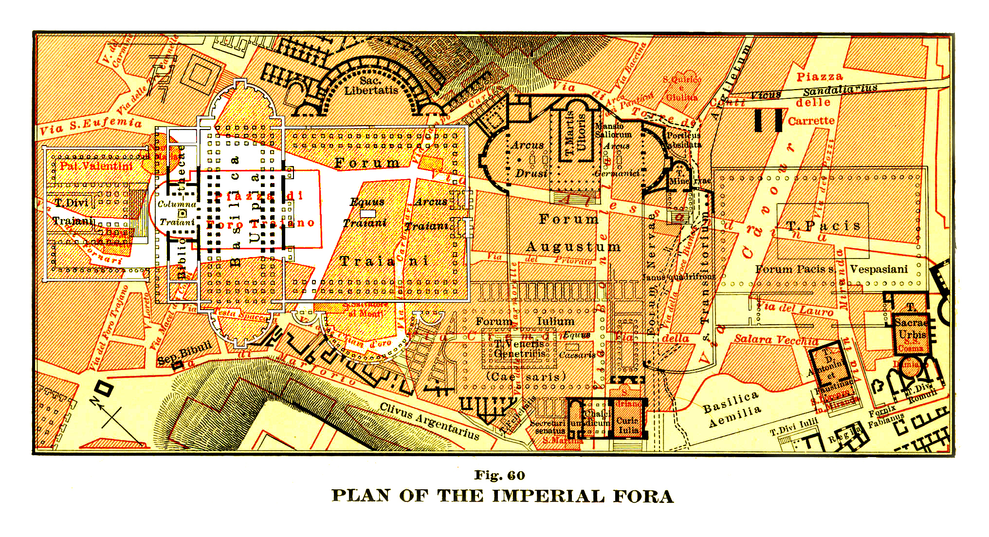
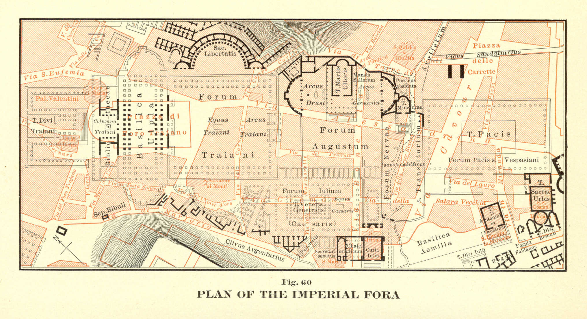
파일:Platner-fora-imperial-96a Recontructed.jpg
미리 보기 크기: 800 × 434 픽셀 다른 해상도: 320 × 174 픽셀 | 640 × 347 픽셀 | 1,024 × 556 픽셀 | 1,280 × 695 픽셀 | 2,032 × 1,103 픽셀
원본 파일 (2,032 × 1,103 픽셀, 파일 크기: 3.12 MB, MIME 종류: image/jpeg)
파일 설명
| 설명 | Archaeological map of the Imperial Forum of Rome Modified from original scan for color and contrast to show Trajan's Forum |
| 날짜 | |
| 출처 | http://images.google.com/imgres?imgurl=http://www.utexas.edu/courses/romanciv/Romancivimages23/basicilaplan.jpg&imgrefurl=http://intranet.dalton.org/groups/rome/Italia.html&usg=__hxEscg-mQ83fYhTsjG_xuu8Odd4=&h=367&w=500&sz=80&hl=en&start=57&sig2=04Cg-4erfiAL2iPrkupnSA&um=1&tbnid=L4GS4q_wlpaFBM:&tbnh=95&tbnw=130&ei=6f9aSbI-jIawA9rE6IUN&prev=/images%3Fq%3DTrajan%2527s%2Bforum%2Bplans%2Bplatners%26start%3D40%26ndsp%3D20%26um%3D1%26hl%3Den%26rls%3DHPIC,HPIC:2008-44,HPIC:en%26sa%3DN |
| 저자 |
Samuel Ball Platner's The Topography and Monuments of Ancient Rome (Boston: Allyn and Bacon, 1904) scanned by Felix Just, S.J., Ph.D. |
| 저작권 (이 파일을 인용하기) |
Granted for educational use |
| 다른 버전 | http://catholic-resources.org/AncientRome/Platner-fora-imperial-96.jpg |
라이선스
|
이 작품은 미국, 그리고 저작권 보호 기간이 저작자 사후 100년, 또는 그 이하인 모든 국가에서 퍼블릭 도메인입니다. | |
| 이 저작물은 모든 저작인접권을 포함한 저작권법하의 규제로부터 자유로운 것으로 확인되었습니다. | |
파일 역사
날짜/시간 링크를 클릭하면 해당 시간의 파일을 볼 수 있습니다.
| 날짜/시간 | 섬네일 | 크기 | 사용자 | 설명 | |
|---|---|---|---|---|---|
| 현재 | 2008년 12월 31일 (수) 16:41 | | 2,032 × 1,103 (3.12 MB) | Amadscientist | {{Information |Description= Archaeological map of the Imperial Forum of Rome |Source=http://images.google.com/imgres?imgurl=http://www.utexas.edu/courses/romanciv/Romancivimages23/basicilaplan.jpg&imgrefurl=http://intranet.dalton.org/groups/rome/Italia.ht |
이 파일을 사용하는 문서
다음 문서 1개가 이 파일을 사용하고 있습니다:
이 파일을 사용하고 있는 모든 위키의 문서 목록
다음 위키에서 이 파일을 사용하고 있습니다:
- el.wikipedia.org에서 이 파일을 사용하고 있는 문서 목록
- en.wikipedia.org에서 이 파일을 사용하고 있는 문서 목록
- sk.wikipedia.org에서 이 파일을 사용하고 있는 문서 목록
- sl.wikipedia.org에서 이 파일을 사용하고 있는 문서 목록