
파일:Picton Lennox and Nueva.png
최대 해상도입니다.
Picton_Lennox_and_Nueva.png (800 × 600 픽셀, 파일 크기: 38 KB, MIME 종류: image/png)
Largely self-made, using www.planiglobe.com (License archive copy at the Wayback Machine) as source for cartographic data and colors from CIA World Factbook maps.
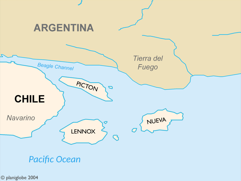
These Islands are part of Chile and where disputed by Chile and Argentina until 1985.
Author: Cantus
이 파일은 크리에이티브 커먼즈 저작자표시 2.5 일반 라이선스로 배포됩니다.
- 이용자는 다음의 권리를 갖습니다:
- 공유 및 이용 – 저작물의 복제, 배포, 전시, 공연 및 공중송신
- 재창작 – 저작물의 개작, 수정, 2차적저작물 창작
- 다음과 같은 조건을 따라야 합니다:
- 저작자표시 – 적절한 저작자 표시를 제공하고, 라이센스에 대한 링크를 제공하고, 변경사항이 있는지를 표시해야 합니다. 당신은 합리적인 방식으로 표시할 수 있지만, 어떤 방식으로든 사용권 허가자가 당신 또는 당신의 사용을 지지하는 방식으로 표시할 수 없습니다.
Planiglobe license:
| This image is from Planiglobe. All maps hosted on Planiglobe are licensed under the Creative Commons Attribution 2.5 License, but Planiglobe suggests that they not be used for navigational purposes. For the purposes of this license, this clause is considered a disclaimer and not a license restriction. 이 파일은 크리에이티브 커먼즈 저작자표시 2.5 일반 라이선스로 배포됩니다.
|
파일 역사
날짜/시간 링크를 클릭하면 해당 시간의 파일을 볼 수 있습니다.
| 날짜/시간 | 섬네일 | 크기 | 사용자 | 설명 | |
|---|---|---|---|---|---|
| 현재 | 2018년 1월 2일 (화) 06:36 | | 800 × 600 (38 KB) | Janitoalevic | . |
| 2005년 9월 2일 (금) 07:24 |  | 800 × 600 (21 KB) | B1mbo | Largely self-made, using www.planiglobe.com ([http://www.planiglobe.com/eula.html License]) as source for cartographic data and colors from CIA World Factbook maps. Author: Cantus {{CopyrightedFreeUse}} Category:Maps of Chile |
이 파일을 사용하는 문서
다음 문서 1개가 이 파일을 사용하고 있습니다:
이 파일을 사용하고 있는 모든 위키의 문서 목록
다음 위키에서 이 파일을 사용하고 있습니다:
- ast.wikipedia.org에서 이 파일을 사용하고 있는 문서 목록
- eo.wikipedia.org에서 이 파일을 사용하고 있는 문서 목록
- es.wikipedia.org에서 이 파일을 사용하고 있는 문서 목록
- fr.wikipedia.org에서 이 파일을 사용하고 있는 문서 목록
- it.wikipedia.org에서 이 파일을 사용하고 있는 문서 목록
- ja.wikipedia.org에서 이 파일을 사용하고 있는 문서 목록
- no.wikipedia.org에서 이 파일을 사용하고 있는 문서 목록
- pl.wikipedia.org에서 이 파일을 사용하고 있는 문서 목록
- pt.wikipedia.org에서 이 파일을 사용하고 있는 문서 목록
- tr.wikipedia.org에서 이 파일을 사용하고 있는 문서 목록
- www.wikidata.org에서 이 파일을 사용하고 있는 문서 목록