
파일:Paraná River Floodplain, Northern Argentina.jpg

원본 파일 (4,288 × 2,850 픽셀, 파일 크기: 3.8 MB, MIME 종류: image/jpeg)
파일 설명
| 설명 |
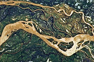
English: This astronaut photograph shows a 29-kilometre stretch of the Paraná, downstream of the small city of Goya, Argentina (just off the top left of the image).
The Paraná River ranges up to 3 kilometres wide along the reach illustrated in this image. The main channel is deep enough to allow smaller ocean-going ships to pass north to the capital city of Asunción, Paraguay, fully 1,200 kilometres inland and well out of the image. The river’s dark brown shading indicates a heavy load of muddy sediment; smaller side channels also carry this mud. Numerous lakes are typical on active floodplains, and appear here as irregular bodies of water. Some appear brown, indicating that they probably have been refilled during recent rises and floods of the active channels. The Paraná floodplain occupies the entire image; it is so wide—18 kilometres in this view—that its banks are not visible. Numerous curved, meandering channels are the most prominent characteristic of the floodplain, indicating prior positions of the river and its channels. As riverbeds move laterally by natural processes, they leave remnants of their channels, which appear as lakes and finally fill with mud. This is an excellent image for illustrating these meander forms. From a geological standpoint, it is interesting that almost all of the old channels are similar in curvature to today’s side channels. However, almost none of them seem to show prior positions of the main, wide Paraná channel. |
| 날짜 | |
| 출처 | NASA Earth Observatory |
| 저자 | ISS Expedition 27 crew |
| 카메라 위치 | | 이 지역의 다른 사진을 보기: OpenStreetMap |
|---|
This image or video was catalogued by Johnson Space Center of the United States National Aeronautics and Space Administration (NASA) under Photo ID: ISS027-E-11058. This tag does not indicate the copyright status of the attached work. A normal copyright tag is still required. See Commons:Licensing. Other languages:
|
Image acquired with a Nikon D2Xs digital camera using a 400 mm lens, and is provided by the ISS Crew Earth Observations experiment and Image Science & Analysis Laboratory, Johnson Space Center.
라이선스
| 이 파일은 NASA에서 제작하였으므로 퍼블릭 도메인입니다. NASA의 저작권 정책에 따르면 NASA의 자료는 명시하지 않는 이상 저작권의 보호를 받지 않습니다. (Template:PD-USGov, 또는 NASA 저작권 정책 문서, JPL 그림 사용 정책을 참고하세요.) | ||
 |
주의사항:
|
| 주석 | 이 이미지에는 주석이 있습니다: 공용에서 주석을 보기 |
파일 역사
날짜/시간 링크를 클릭하면 해당 시간의 파일을 볼 수 있습니다.
| 날짜/시간 | 섬네일 | 크기 | 사용자 | 설명 | |
|---|---|---|---|---|---|
| 현재 | 2011년 5월 2일 (월) 20:54 | | 4,288 × 2,850 (3.8 MB) | Originalwana |
이 파일을 사용하는 문서
다음 문서 1개가 이 파일을 사용하고 있습니다:
이 파일을 사용하고 있는 모든 위키의 문서 목록
다음 위키에서 이 파일을 사용하고 있습니다:
- ar.wikipedia.org에서 이 파일을 사용하고 있는 문서 목록
- de.wikipedia.org에서 이 파일을 사용하고 있는 문서 목록
- en.wikipedia.org에서 이 파일을 사용하고 있는 문서 목록
- eo.wikipedia.org에서 이 파일을 사용하고 있는 문서 목록
- fa.wikipedia.org에서 이 파일을 사용하고 있는 문서 목록
- he.wikipedia.org에서 이 파일을 사용하고 있는 문서 목록
- mk.wikipedia.org에서 이 파일을 사용하고 있는 문서 목록
- ml.wikipedia.org에서 이 파일을 사용하고 있는 문서 목록
- sr.wikipedia.org에서 이 파일을 사용하고 있는 문서 목록
- uk.wikipedia.org에서 이 파일을 사용하고 있는 문서 목록
- ur.wikipedia.org에서 이 파일을 사용하고 있는 문서 목록