
파일:PIA16068 - Mars Curiosity Rover - Aeolis Mons - 20120817.jpg

원본 파일 (3,294 × 1,568 픽셀, 파일 크기: 583 KB, MIME 종류: image/jpeg)
파일 설명
| 설명 |
English: 08.17.2012
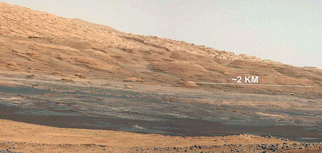
The Promised Land This image (cut out from a mosaic) shows the view from the landing site of NASA's Curiosity rover toward the lower reaches of Mount Sharp, where Curiosity is likely to begin its ascent through hundreds of feet (meters) of layered deposits. The lower several hundred feet (meters) show evidence of bearing hydrated minerals, based on orbiter observations. The terrain Curiosity will explore is marked by hills, buttes, mesas and canyons on the scale of one-to-three story buildings, very much like the Four Corners region of the western United States. A scale bar indicates a distance of 1.2 miles (2 kilometers). Curiosity's 34-millimeter Mast Camera acquired this high-resolution image on Aug. 8, 2012 PDT (Aug. 9 EDT). This image shows the colors modified as if the scene were transported to Earth and illuminated by terrestrial sunlight. This processing, called "white balancing," is useful to scientists for recognizing and distinguishing rocks by color in more familiar lighting. Image Credit: NASA/JPL-Caltech/MSSS |
| 날짜 | |
| 출처 | https://photojournal.jpl.nasa.gov/catalog/PIA16068 |
| 저자 | NASA/JPL-Caltech/MSSS |
라이선스
| 이 파일은 NASA에서 제작하였으므로 퍼블릭 도메인입니다. NASA의 저작권 정책에 따르면 NASA의 자료는 명시하지 않는 이상 저작권의 보호를 받지 않습니다. (Template:PD-USGov, 또는 NASA 저작권 정책 문서, JPL 그림 사용 정책을 참고하세요.) | ||
 |
주의사항:
|
파일 역사
날짜/시간 링크를 클릭하면 해당 시간의 파일을 볼 수 있습니다.
| 날짜/시간 | 섬네일 | 크기 | 사용자 | 설명 | |
|---|---|---|---|---|---|
| 현재 | 2012년 8월 18일 (토) 03:24 | | 3,294 × 1,568 (583 KB) | Drbogdan |
이 파일을 사용하는 문서
다음 문서 1개가 이 파일을 사용하고 있습니다:
이 파일을 사용하고 있는 모든 위키의 문서 목록
다음 위키에서 이 파일을 사용하고 있습니다:
- azb.wikipedia.org에서 이 파일을 사용하고 있는 문서 목록
- az.wikipedia.org에서 이 파일을 사용하고 있는 문서 목록
- bn.wikipedia.org에서 이 파일을 사용하고 있는 문서 목록
- ca.wikipedia.org에서 이 파일을 사용하고 있는 문서 목록
- en.wikipedia.org에서 이 파일을 사용하고 있는 문서 목록
- fa.wikipedia.org에서 이 파일을 사용하고 있는 문서 목록
- ja.wikipedia.org에서 이 파일을 사용하고 있는 문서 목록
- kk.wikipedia.org에서 이 파일을 사용하고 있는 문서 목록
- mk.wikipedia.org에서 이 파일을 사용하고 있는 문서 목록
- ro.wikipedia.org에서 이 파일을 사용하고 있는 문서 목록
- ru.wikipedia.org에서 이 파일을 사용하고 있는 문서 목록
- test.wikipedia.org에서 이 파일을 사용하고 있는 문서 목록
- th.wikipedia.org에서 이 파일을 사용하고 있는 문서 목록
- tr.wikipedia.org에서 이 파일을 사용하고 있는 문서 목록
- uk.wikipedia.org에서 이 파일을 사용하고 있는 문서 목록
- zh.wikipedia.org에서 이 파일을 사용하고 있는 문서 목록