
파일:Northern Pacific Railroad map circa 1900.jpg

미리 보기 크기: 800 × 304 픽셀 다른 해상도: 320 × 121 픽셀 | 640 × 243 픽셀 | 1,024 × 389 픽셀 | 1,280 × 486 픽셀 | 2,560 × 971 픽셀 | 8,850 × 3,358 픽셀
원본 파일 (8,850 × 3,358 픽셀, 파일 크기: 8.9 MB, MIME 종류: image/jpeg)
파일 설명
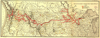
| 설명 | Map showing the en:Northern Pacific Railway route circa 1900. |
| 날짜 | 2005년 11월 29일 (원본 올리기 일시) |
| 출처 |
Ian13 사용자가 CommonsHelper 도구를 사용하여 en.wikipedia에서 공용으로 옮겨왔습니다. Higher resolution JPEG2000 file obtained from [1] and converted to JPEG. |
| 저자 |
The original uploader was 영어 위키백과의 Slambo. Later version(s) were uploaded by Ian13 at en.wikipedia. Map created by L.L. Poates Engr'g Co., New York, 1900. Image from the Library of Congress map collection, call number G4126.P3 1900 .L55 RR 502. From Fourth Annual Report of the Northern Pacific Railway company, for the Fiscal Year ending June 30, 1900. Signed in ms: "W. Lowery." Reference: LC Railroad maps, 502. Scale not given. |
| 저작권 (이 파일을 인용하기) |
"The Library of Congress ... is not aware of any U.S. copyright protection (see Title 17 of the United States Code) or any other restrictions in the Map Collection materials." (Source retrieved 2005-11-29) |
| 다른 버전 |
이 파일은 다음으로 파생됨:
|
라이선스
This media file is in the public domain in the United States. This applies to U.S. works where the copyright has expired, often because its first publication occurred prior to January 1, 1929, and if not then due to lack of notice or renewal. See this page for further explanation.
|
 | |
 |
This image might not be in the public domain outside of the United States; this especially applies in the countries and areas that do not apply the rule of the shorter term for US works, such as Canada, Mainland China (not Hong Kong or Macao), Germany, Mexico, and Switzerland. The creator and year of publication are essential information and must be provided. See Wikipedia:Public domain and Wikipedia:Copyrights for more details.
|
기존 올리기 기록
The original description page was here. All following user names refer to en.wikipedia.
- 2008-07-15 21:38 Ian13 8850×3358×8 (9327163 bytes) '
- 2005-11-29 12:21 Slambo 552×208×8 (46806 bytes) Map showing the [[Northern Pacific Railroad]] route circa 1900. Map created by L.L. Poates Engr'g Co., New York, 1900. Image from the Library of Congress map collection, call number G4126.P3 1900 .L55 RR 502. [http://memory.loc.gov/cgi-bin/ammemrr.pl?ti
Original edit log
- (cur) (last) 22:43, 15 July 2008 Ian13 (Talk | contribs | block) (1,127 bytes) (tidy + commons tag) (rollback | undo)
- (cur) (last) 22:38, 15 July 2008 Ian13 (Talk | contribs | block) (uploaded a new version of "Image:Northern Pacific Railroad map circa 1900.jpg") (undo)
- (cur) (last) 22:31, 15 July 2008 Ian13 (Talk | contribs | block) m (1,115 bytes) (→Summary: update) (undo)
- (cur) (last) 08:38, 21 June 2006 Lordkinbote (Talk | contribs | block) m (add cat) (undo)
- (cur) (last) 13:21, 29 November 2005 Slambo (Talk | contribs | block) (Map showing the Northern Pacific Railroad route circa 1900. Map created by L.L. Poates Engr'g Co., New York, 1900. Image from the Library of Congress map collection, call number G4126.P3 1900 .L55 RR 502. [http://memory.loc.gov/cgi-bin/ammemrr.pl?ti)
파일 역사
날짜/시간 링크를 클릭하면 해당 시간의 파일을 볼 수 있습니다.
| 날짜/시간 | 섬네일 | 크기 | 사용자 | 설명 | |
|---|---|---|---|---|---|
| 현재 | 2008년 7월 16일 (수) 07:03 | 8,850 × 3,358 (8.9 MB) | Ian13 | {{Information |Description={{en|Map showing the en:Northern Pacific Railroad route circa 1900. Map created by L.L. Poates Engr'g Co., New York, 1900. Image from the Library of Congress map collection, call number G4126.P3 1900 .L55 RR 502. From Four |
이 파일을 사용하는 문서
다음 문서 1개가 이 파일을 사용하고 있습니다:
이 파일을 사용하고 있는 모든 위키의 문서 목록
다음 위키에서 이 파일을 사용하고 있습니다:
- de.wikipedia.org에서 이 파일을 사용하고 있는 문서 목록
- en.wikipedia.org에서 이 파일을 사용하고 있는 문서 목록
- fr.wikipedia.org에서 이 파일을 사용하고 있는 문서 목록
- it.wikipedia.org에서 이 파일을 사용하고 있는 문서 목록
- ja.wikipedia.org에서 이 파일을 사용하고 있는 문서 목록
- no.wikipedia.org에서 이 파일을 사용하고 있는 문서 목록
- www.wikidata.org에서 이 파일을 사용하고 있는 문서 목록