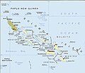
파일:Political map of the Solomon Islands archipelago in 1989.jpg

미리 보기 크기: 690 × 600 픽셀 다른 해상도: 276 × 240 픽셀 | 552 × 480 픽셀 | 748 × 650 픽셀
원본 파일 (748 × 650 픽셀, 파일 크기: 72 KB, MIME 종류: image/jpeg)
파일 역사
날짜/시간 링크를 클릭하면 해당 시간의 파일을 볼 수 있습니다.
| 날짜/시간 | 섬네일 | 크기 | 사용자 | 설명 | |
|---|---|---|---|---|---|
| 현재 | 2016년 4월 12일 (화) 11:06 |  | 748 × 650 (72 KB) | Nimbosa | Reverted to version as of 02:02, 12 April 2016 (UTC) |
| 2016년 4월 12일 (화) 11:05 |  | 748 × 650 (72 KB) | Nimbosa | restored to original color as on print, corrected color map | |
| 2016년 4월 12일 (화) 11:02 |  | 748 × 650 (72 KB) | Nimbosa | restored to original color as on print, corrected color map | |
| 2007년 3월 2일 (금) 06:09 |  | 748 × 650 (72 KB) | Pibwl |
이 파일을 사용하는 문서
이 파일을 사용하고 있는 모든 위키의 문서 목록
다음 위키에서 이 파일을 사용하고 있습니다:
- als.wikipedia.org에서 이 파일을 사용하고 있는 문서 목록
- ami.wikipedia.org에서 이 파일을 사용하고 있는 문서 목록
- ast.wikipedia.org에서 이 파일을 사용하고 있는 문서 목록
- bg.wikipedia.org에서 이 파일을 사용하고 있는 문서 목록
- bn.wikipedia.org에서 이 파일을 사용하고 있는 문서 목록
- ca.wikipedia.org에서 이 파일을 사용하고 있는 문서 목록
- ceb.wikipedia.org에서 이 파일을 사용하고 있는 문서 목록
- cs.wikipedia.org에서 이 파일을 사용하고 있는 문서 목록
- da.wikipedia.org에서 이 파일을 사용하고 있는 문서 목록
- el.wikipedia.org에서 이 파일을 사용하고 있는 문서 목록
- en.wikipedia.org에서 이 파일을 사용하고 있는 문서 목록
- New Georgia Islands
- Solomon Islands rain forests
- New Georgia Sound
- New Georgia
- North Solomon Islands
- Solomon Archipelago
- List of resident commissioners and governors of the Solomon Islands
- Solomon Islands (archipelago)
- Bougainville Strait
- Coral reefs of the Solomon Islands
- Draft:Arthur William Mahaffy
- en.wiktionary.org에서 이 파일을 사용하고 있는 문서 목록
- es.wikipedia.org에서 이 파일을 사용하고 있는 문서 목록
- fa.wikipedia.org에서 이 파일을 사용하고 있는 문서 목록
- fi.wikipedia.org에서 이 파일을 사용하고 있는 문서 목록
- fr.wikipedia.org에서 이 파일을 사용하고 있는 문서 목록
- gl.wikipedia.org에서 이 파일을 사용하고 있는 문서 목록
- hu.wikipedia.org에서 이 파일을 사용하고 있는 문서 목록
- hy.wikipedia.org에서 이 파일을 사용하고 있는 문서 목록
- hyw.wikipedia.org에서 이 파일을 사용하고 있는 문서 목록
- id.wikipedia.org에서 이 파일을 사용하고 있는 문서 목록
- it.wikipedia.org에서 이 파일을 사용하고 있는 문서 목록
- ja.wikipedia.org에서 이 파일을 사용하고 있는 문서 목록
- ka.wikipedia.org에서 이 파일을 사용하고 있는 문서 목록
- kk.wikipedia.org에서 이 파일을 사용하고 있는 문서 목록
이 파일의 더 많은 사용 내역을 봅니다.


