
파일:NetherlandsNewGuinea-1916.jpg

원본 파일 (3,000 × 1,895 픽셀, 파일 크기: 6.3 MB, MIME 종류: image/jpeg)
파일 설명

|
This image needs restoration.
If the old version is still useful, for example if restoring the image will alter the image significantly, upload the new version under a different title so that both can be used (e.g. [[File:Mount_Everest.jpg]] → [[File:Mount_Everest - restored.jpg]]. After uploading the restored version, replace this template with:
{{superseded|File:Mount Everest - restored.jpg|image restored}}, replacing the italicised name with the file name in question.
|
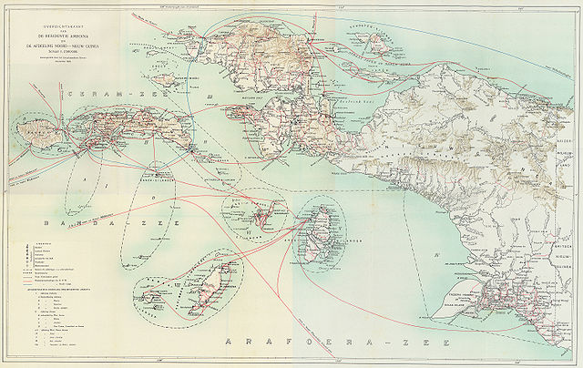
Steamboat connections in Netherlands New Guinea (1915)
This map, published in 1915, is an overview of steamboat connections in the Western New Guinea region. The image was published in Batavia (now Jakarta, Indonesia) in what was then known as the Dutch East Indies. The map is published by a company called G. Kolff & Co and uploaded by PapuaWeb.org archive copy at the Wayback Machine on the Maps of Papua archive copy at the Wayback Machine page. As per the Netherlands Copyright Act of 1912 archive copy at the Wayback Machine, which applies to works published in the Dutch East Indies (Article 47a), the copyright has expired on 1 January 1986 because only the publishing company, not the author, is known (Article 38).
From en:Image:NetherlandsNewGuinea-1916.jpg by en:User:Arsonal
라이선스
|
이 작품은 미국, 그리고 저작권 보호 기간이 저작자 사후 70년, 또는 그 이하인 모든 국가에서 퍼블릭 도메인입니다.
| |
| 이 저작물은 모든 저작인접권을 포함한 저작권법하의 규제로부터 자유로운 것으로 확인되었습니다. | |
파일 역사
날짜/시간 링크를 클릭하면 해당 시간의 파일을 볼 수 있습니다.
| 날짜/시간 | 섬네일 | 크기 | 사용자 | 설명 | |
|---|---|---|---|---|---|
| 현재 | 2006년 7월 7일 (금) 06:52 | | 3,000 × 1,895 (6.3 MB) | Hardscarf | == Summary == === Military Expeditions to Nederlands Nieuw-Guinea 1907-1915 === This map published in 1916 is a documentation of Dutch military expeditions to the Western New Guinea region. The image was published in Batavia (now Jakarta, Indonesia) in |
이 파일을 사용하는 문서
다음 문서 1개가 이 파일을 사용하고 있습니다:
이 파일을 사용하고 있는 모든 위키의 문서 목록
다음 위키에서 이 파일을 사용하고 있습니다:
- ar.wikipedia.org에서 이 파일을 사용하고 있는 문서 목록
- arz.wikipedia.org에서 이 파일을 사용하고 있는 문서 목록
- ban.wikipedia.org에서 이 파일을 사용하고 있는 문서 목록
- ca.wikipedia.org에서 이 파일을 사용하고 있는 문서 목록
- cs.wikipedia.org에서 이 파일을 사용하고 있는 문서 목록
- de.wikipedia.org에서 이 파일을 사용하고 있는 문서 목록
- en.wikipedia.org에서 이 파일을 사용하고 있는 문서 목록
- eo.wikipedia.org에서 이 파일을 사용하고 있는 문서 목록
- es.wikipedia.org에서 이 파일을 사용하고 있는 문서 목록
- fr.wikipedia.org에서 이 파일을 사용하고 있는 문서 목록
- id.wikipedia.org에서 이 파일을 사용하고 있는 문서 목록
- it.wikipedia.org에서 이 파일을 사용하고 있는 문서 목록
- ja.wikipedia.org에서 이 파일을 사용하고 있는 문서 목록
- nl.wikipedia.org에서 이 파일을 사용하고 있는 문서 목록
- pam.wikipedia.org에서 이 파일을 사용하고 있는 문서 목록
- pl.wikipedia.org에서 이 파일을 사용하고 있는 문서 목록
- pt.wikipedia.org에서 이 파일을 사용하고 있는 문서 목록
- ru.wikipedia.org에서 이 파일을 사용하고 있는 문서 목록
- sq.wikipedia.org에서 이 파일을 사용하고 있는 문서 목록
- sv.wikipedia.org에서 이 파일을 사용하고 있는 문서 목록
- tr.wikipedia.org에서 이 파일을 사용하고 있는 문서 목록
- www.wikidata.org에서 이 파일을 사용하고 있는 문서 목록
- zea.wikipedia.org에서 이 파일을 사용하고 있는 문서 목록
- zh.wikipedia.org에서 이 파일을 사용하고 있는 문서 목록