
파일:NEAT GBT engl.png

미리 보기 크기: 539 × 600 픽셀 다른 해상도: 216 × 240 픽셀 | 431 × 480 픽셀 | 852 × 948 픽셀
원본 파일 (852 × 948 픽셀, 파일 크기: 1.91 MB, MIME 종류: image/png)
파일 설명
| 설명 |
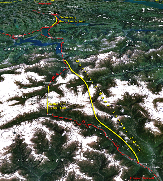
Situation of the northern part of the Gotthard axis as part of the New Railway Link through the Alps NRLA / Alptransit project in Switzerland with Gotthard and Zimmerberg base tunnels |
| 날짜 | |
| 출처 | topomap: produced with NASA WorldWind 1.3 / overlay drawing by: Cooper.ch |
| 저자 | --Cooper.ch 19:30, 12 August 2006 (UTC) |
| 저작권 (이 파일을 인용하기) |
NASA satellite imagery is in public domain, and so is my overlay drawing |
| 다른 버전 | Original german version on de.wikipedia.org, named Bild:NEAT_Gotthardachse.png |
라이선스
| 이 파일은 NASA에서 제작하였으므로 퍼블릭 도메인입니다. NASA의 저작권 정책에 따르면 NASA의 자료는 명시하지 않는 이상 저작권의 보호를 받지 않습니다. (Template:PD-USGov, 또는 NASA 저작권 정책 문서, JPL 그림 사용 정책을 참고하세요.) | ||
 |
주의사항:
|
| 주석 | 이 이미지에는 주석이 있습니다: 공용에서 주석을 보기 |


파일 역사
날짜/시간 링크를 클릭하면 해당 시간의 파일을 볼 수 있습니다.
| 날짜/시간 | 섬네일 | 크기 | 사용자 | 설명 | |
|---|---|---|---|---|---|
| 현재 | 2006년 8월 13일 (일) 04:30 | | 852 × 948 (1.91 MB) | Cooper.ch | {{Information |Description=Situation of the northern axis of the New Railway Link through the Alps NRLA in Switzerland with Gotthard and Zimmerberg base tunnels |Source=topomap: produced with NASA WorldWind 1.3 / drawing overlay by: [[User:Cooper.ch|Coope |
이 파일을 사용하는 문서
이 파일을 사용하는 문서가 없습니다.
이 파일을 사용하고 있는 모든 위키의 문서 목록
다음 위키에서 이 파일을 사용하고 있습니다:
- ast.wikipedia.org에서 이 파일을 사용하고 있는 문서 목록
- bh.wikipedia.org에서 이 파일을 사용하고 있는 문서 목록
- da.wikipedia.org에서 이 파일을 사용하고 있는 문서 목록
- en.wikipedia.org에서 이 파일을 사용하고 있는 문서 목록
- es.wikipedia.org에서 이 파일을 사용하고 있는 문서 목록
- fa.wikipedia.org에서 이 파일을 사용하고 있는 문서 목록
- fi.wikipedia.org에서 이 파일을 사용하고 있는 문서 목록
- fr.wikipedia.org에서 이 파일을 사용하고 있는 문서 목록
- he.wikipedia.org에서 이 파일을 사용하고 있는 문서 목록
- hr.wikipedia.org에서 이 파일을 사용하고 있는 문서 목록
- ja.wikipedia.org에서 이 파일을 사용하고 있는 문서 목록
- jv.wikipedia.org에서 이 파일을 사용하고 있는 문서 목록
- ml.wikipedia.org에서 이 파일을 사용하고 있는 문서 목록
- my.wikipedia.org에서 이 파일을 사용하고 있는 문서 목록
- nl.wikipedia.org에서 이 파일을 사용하고 있는 문서 목록
- no.wikipedia.org에서 이 파일을 사용하고 있는 문서 목록
- pt.wikipedia.org에서 이 파일을 사용하고 있는 문서 목록
- rm.wikipedia.org에서 이 파일을 사용하고 있는 문서 목록
- ro.wikipedia.org에서 이 파일을 사용하고 있는 문서 목록
- sh.wikipedia.org에서 이 파일을 사용하고 있는 문서 목록
- sl.wikipedia.org에서 이 파일을 사용하고 있는 문서 목록
- sv.wikipedia.org에서 이 파일을 사용하고 있는 문서 목록
- ta.wikinews.org에서 이 파일을 사용하고 있는 문서 목록
- tr.wikipedia.org에서 이 파일을 사용하고 있는 문서 목록
- zh.wikipedia.org에서 이 파일을 사용하고 있는 문서 목록