
파일:Map of Colchis, Iberia, Albania, and the neighbouring countries ca 1770.jpg

미리 보기 크기: 800 × 598 픽셀 다른 해상도: 320 × 239 픽셀 | 640 × 479 픽셀 | 1,016 × 760 픽셀
원본 파일 (1,016 × 760 픽셀, 파일 크기: 194 KB, MIME 종류: image/jpeg)
파일 설명
| 설명 |
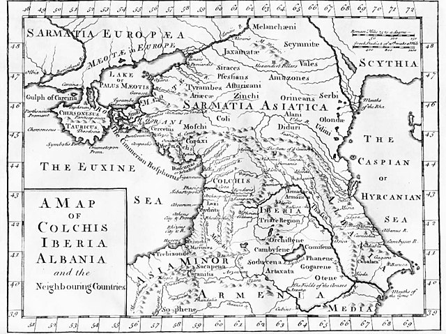
English: "A Map of Colchis, Iberia, Albania, and the neighbouring countries". A map of the Caucasus / Crimea (Chersonesus Tauricus)/ southern Russia region during classical antiquity (the ancient period). Note that the "Albania" referred to was on the Caspian Sea (not the modern Albania in the Balkans). Copper-engraved map, no publisher or date, London, ca 1770 (or 1729?).
Deutsch: Kaukasus mit Siedlungsgebieten von Sarmaten und Amazonen in der Antike, Kupferstich von ca. 1770
Français : La Colchide, l’Ibérie (orientale), l’Albanie (orientale) et les régions voisines
ქართული: ანტიკური ხანის კოლხეთი, ბერძნულ წყაროებზე დაყრდნობით, დაბეჭდილია ლონდონში, 1770.
Nederlands: Kaart van de Kaukasus, ca. 1770
Русский: «Европейская Сарматия». Карта основана на греческих литературных источниках, напечатана в Лондоне в 1770 |
| 날짜 | 1770년경 |
| 출처 |
|
| 저자 | last upload en:User:AnonMoos |
라이선스
|
이 그림은 2차원 저작물에 대한 사진 복제본으로, 원본 저작물은 현재 저작권이 풀려 있는 퍼블릭 도메인 하에 있으며, 구체적인 정보는 아래와 같습니다.
위키미디어 재단에서는 2차원 저작물의 사진 복제본에 대해서 ‘2차원 퍼블릭 도메인의 사진 복제본은 역시 퍼블릭 도메인이라고 생각하며, 또한 이러한 주장은 일반적인 퍼블릭 도메인에 대한 개념으로, 이에 대한 반대는 일반적으로 사용되는 퍼블릭 도메인의 개념 자체를 반대하는 것이다’라고 입장을 밝혔습니다. 자세한 설명은 PD-Art 틀을 사용하는 경우 문서를 참조해주세요.
따라서, 이 사진 복제본은 역시 퍼블릭 도메인으로 간주됩니다. 그림을 사용할 때에는 해당 국가와 지역의 법을 확인해 주시기 바랍니다. 경우에 따라서는 관할 구역의 법에 의해 사용이 제한되어 있을 수 있습니다. 자세한 사항은 PD-Art 틀을 사용하는 경우를 확인해주세요. | ||||
기존 올리기 기록
File upload history on en:
- 20:53, 27 October 2005 . . AnonMoos (Talk) . . 1016x760 (198173 bytes) (Version of image losslessly cropped to region of interest with Jpegcrop program. )
- 20:32, 3 July 2005 . . PANONIAN (Talk) . . 1254x760 (224060 bytes) (historic map )
| date/time | username | resolution | size | edit summary | |
|---|---|---|---|---|---|
| 14:53, 29 December 2005 | User:Ustas | <a href="http://upload.wikimedia.org/wikipedia/commons/d/df/1729.jpg"><img alt="Thumbnail for version as of 14:53, 29 December 2005" src="http://upload.wikimedia.org/wikipedia/commons/thumb/d/df/1729.jpg/120px-1729.jpg" width="120" height="90" border="0" /></a> | 1,016×760 | 194 KB | {{Information |Description = Copper-engraved map, no publisher or date, London, ca 1770. |Source = <a href="http://en.wikipedia.org/wiki/Image:1729.jpg" class="extiw" title="en:Image:1729.jpg">en:Image:1729.jpg</a>, [http://www.village-atlas.com/ancient/ancient.html] |Date = |Author = last upload <a href="http://en.wikipedia.org/wiki/User:AnonMoos" class="extiw" title="en:User:AnonMoos">en:User:AnonMoos</a> |Permission = PD |other_ver |
파일 역사
날짜/시간 링크를 클릭하면 해당 시간의 파일을 볼 수 있습니다.
| 날짜/시간 | 섬네일 | 크기 | 사용자 | 설명 | |
|---|---|---|---|---|---|
| 현재 | 2008년 10월 23일 (목) 01:02 | | 1,016 × 760 (194 KB) | BetacommandBot | move approved by: User:Deadstar This image was moved from Image:1729.jpg {{Information |Description = "A Map of Colchis, Iberia, Albania, and the neighbouring countries". A map of the Caucasus / Crimea / southern Russia region during classical |
이 파일을 사용하는 문서
다음 문서 2개가 이 파일을 사용하고 있습니다:
이 파일을 사용하고 있는 모든 위키의 문서 목록
다음 위키에서 이 파일을 사용하고 있습니다:
- als.wikipedia.org에서 이 파일을 사용하고 있는 문서 목록
- an.wikipedia.org에서 이 파일을 사용하고 있는 문서 목록
- ar.wikipedia.org에서 이 파일을 사용하고 있는 문서 목록
- az.wikipedia.org에서 이 파일을 사용하고 있는 문서 목록
- ba.wikipedia.org에서 이 파일을 사용하고 있는 문서 목록
- bn.wikipedia.org에서 이 파일을 사용하고 있는 문서 목록
- ca.wikipedia.org에서 이 파일을 사용하고 있는 문서 목록
- co.wikipedia.org에서 이 파일을 사용하고 있는 문서 목록
- cy.wikipedia.org에서 이 파일을 사용하고 있는 문서 목록
- da.wikipedia.org에서 이 파일을 사용하고 있는 문서 목록
- de.wikipedia.org에서 이 파일을 사용하고 있는 문서 목록
- el.wikipedia.org에서 이 파일을 사용하고 있는 문서 목록
- en.wikipedia.org에서 이 파일을 사용하고 있는 문서 목록
- es.wikipedia.org에서 이 파일을 사용하고 있는 문서 목록
- eu.wikipedia.org에서 이 파일을 사용하고 있는 문서 목록
- fa.wikipedia.org에서 이 파일을 사용하고 있는 문서 목록
- fi.wikipedia.org에서 이 파일을 사용하고 있는 문서 목록
- fr.wikipedia.org에서 이 파일을 사용하고 있는 문서 목록
- fy.wikipedia.org에서 이 파일을 사용하고 있는 문서 목록
- gl.wikipedia.org에서 이 파일을 사용하고 있는 문서 목록
- he.wikipedia.org에서 이 파일을 사용하고 있는 문서 목록
- hr.wikipedia.org에서 이 파일을 사용하고 있는 문서 목록
- hu.wikipedia.org에서 이 파일을 사용하고 있는 문서 목록
- hyw.wikipedia.org에서 이 파일을 사용하고 있는 문서 목록
- it.wikipedia.org에서 이 파일을 사용하고 있는 문서 목록
이 파일의 더 많은 사용 내역을 봅니다.