
파일:Lunar Thorium concentrations.jpg
미리 보기 크기: 800 × 419 픽셀 다른 해상도: 320 × 168 픽셀 | 640 × 335 픽셀 | 1,024 × 536 픽셀 | 1,280 × 670 픽셀 | 2,100 × 1,100 픽셀
원본 파일 (2,100 × 1,100 픽셀, 파일 크기: 817 KB, MIME 종류: image/jpeg)
| 설명 |
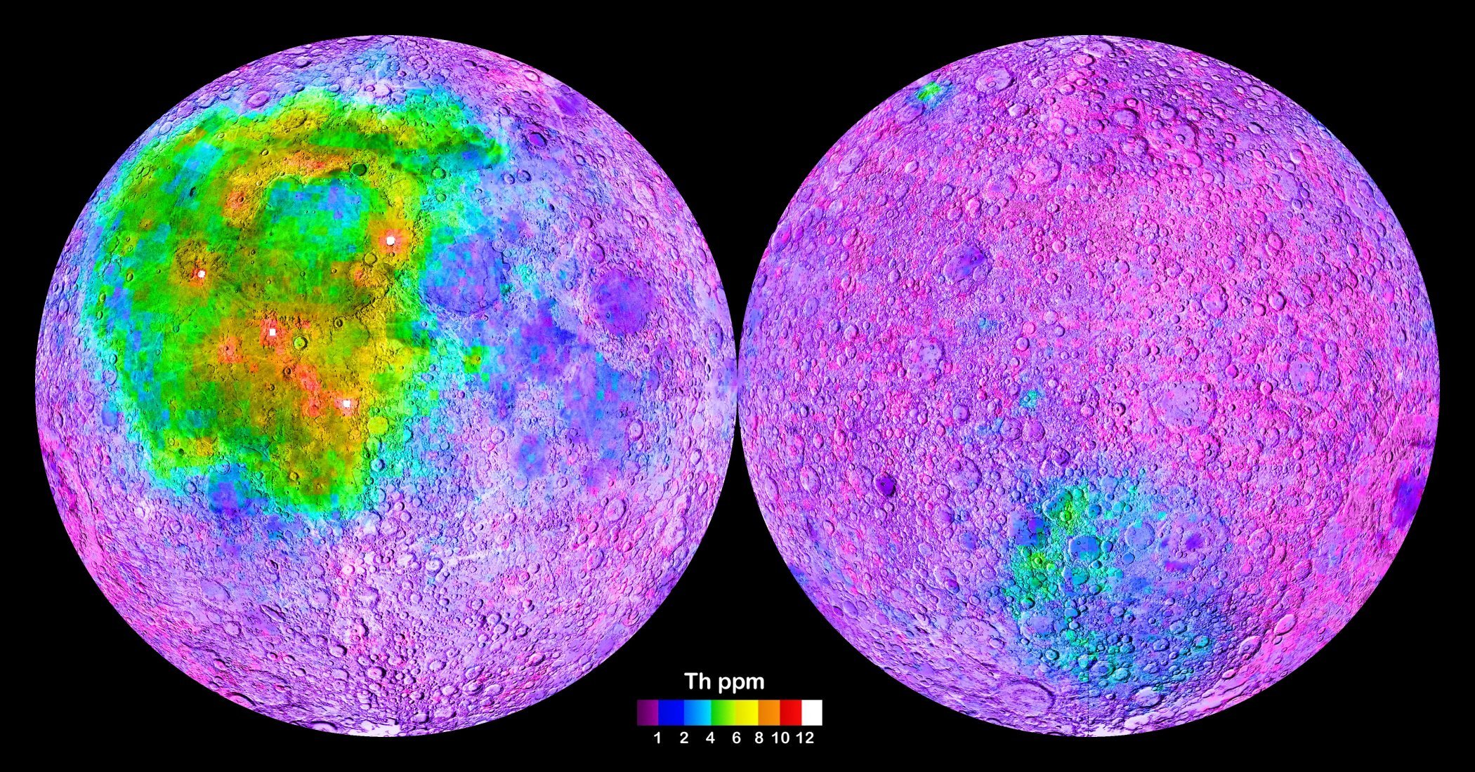
Map of the Moon (left: nearside; right: farside), generated from gamma-spectrometric data collected by the Lunar Prospector vessel. The map shows the global distribution of the element Thorium in surface rocks, with high Thorium concentrations indicating the occurence of the so-called KREEP rocks, which have high contents in Potassium, Rare Earth Elements and Phosphorus. The heterogeneous distribution of KREEP rocks at the moon’s surface implies fundamentally different geological histories of the individual lunar regions (terranes). For further information see Jolliff et al. (2000).[1]
|
|||||
| 날짜 | 2012-05-22, original upload date on en.wikipedia.org was 2012-08-28. Uploaded version is identical to the version transferred to commons. | |||||
| 출처 | http://solarsystem.nasa.gov/multimedia/display.cfm?Category=Planets&IM_ID=13643 | |||||
| 저자 | NASA | |||||
| 저작권 (이 파일을 인용하기) |
|

| 주석 | 이 이미지에는 주석이 있습니다: 공용에서 주석을 보기 |
파일 역사
날짜/시간 링크를 클릭하면 해당 시간의 파일을 볼 수 있습니다.
| 날짜/시간 | 섬네일 | 크기 | 사용자 | 설명 | |
|---|---|---|---|---|---|
| 현재 | 2014년 5월 20일 (화) 06:20 | | 2,100 × 1,100 (817 KB) | Gretarsson | {{Information |Description = Map of the Moon, generated from data collected by the Lunar Prospector vessel. The map shows the global distribution of the element Thorium in surface rocks, with high Thorium concentrations indicating the occurence of the... |
이 파일을 사용하는 문서
다음 문서 1개가 이 파일을 사용하고 있습니다:
이 파일을 사용하고 있는 모든 위키의 문서 목록
다음 위키에서 이 파일을 사용하고 있습니다:
- ba.wikipedia.org에서 이 파일을 사용하고 있는 문서 목록
- cv.wikipedia.org에서 이 파일을 사용하고 있는 문서 목록
- de.wikipedia.org에서 이 파일을 사용하고 있는 문서 목록
- en.wikipedia.org에서 이 파일을 사용하고 있는 문서 목록
- es.wikipedia.org에서 이 파일을 사용하고 있는 문서 목록
- eu.wikipedia.org에서 이 파일을 사용하고 있는 문서 목록
- fr.wikipedia.org에서 이 파일을 사용하고 있는 문서 목록
- fr.wikibooks.org에서 이 파일을 사용하고 있는 문서 목록
- id.wikipedia.org에서 이 파일을 사용하고 있는 문서 목록
- it.wikipedia.org에서 이 파일을 사용하고 있는 문서 목록
- kw.wikipedia.org에서 이 파일을 사용하고 있는 문서 목록
- nl.wikipedia.org에서 이 파일을 사용하고 있는 문서 목록
- pt.wikipedia.org에서 이 파일을 사용하고 있는 문서 목록
- ro.wikipedia.org에서 이 파일을 사용하고 있는 문서 목록
- ru.wikipedia.org에서 이 파일을 사용하고 있는 문서 목록
- uk.wikipedia.org에서 이 파일을 사용하고 있는 문서 목록
- zh.wikipedia.org에서 이 파일을 사용하고 있는 문서 목록