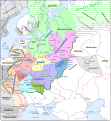
파일:Kievan Rus in 1237 (en).svg

SVG 파일의 PNG 형식의 미리보기 크기: 553 × 600 픽셀. 다른 해상도: 221 × 240 픽셀 | 442 × 480 픽셀 | 708 × 768 픽셀 | 944 × 1,024 픽셀 | 1,888 × 2,048 픽셀 | 1,204 × 1,306 픽셀
원본 파일 (SVG 파일, 실제 크기 1,204 × 1,306 픽셀, 파일 크기: 332 KB)
파일 역사
날짜/시간 링크를 클릭하면 해당 시간의 파일을 볼 수 있습니다.
| 날짜/시간 | 섬네일 | 크기 | 사용자 | 설명 | |
|---|---|---|---|---|---|
| 현재 | 2021년 9월 25일 (토) 17:06 |  | 1,204 × 1,306 (332 KB) | Veverve | "Khvalisy" changed to to "Khvalis" |
| 2021년 4월 10일 (토) 04:16 |  | 1,204 × 1,306 (360 KB) | Veverve | "Principalty of Vladimir-Suzdal" corrected to "Principality of Vladimir-Suzdal" | |
| 2020년 5월 17일 (일) 02:04 |  | 1,204 × 1,306 (360 KB) | Goran tek-en | Named changed as requested by user:Veverve | |
| 2020년 2월 13일 (목) 02:39 |  | 1,204 × 1,306 (318 KB) | Goran tek-en | Changed name of Vladimir as requested bu Veverve | |
| 2020년 2월 13일 (목) 01:59 |  | 1,204 × 1,306 (317 KB) | Goran tek-en | {{Information |description ={{en|1=Map of the Kievan Rus in 1237. The nales of tribes and peoples are in brown, the names of countries outside the Kievan Rus are in black. The names of principalties of the Kievan Rus are in blue; if a principalty bears the a name which comes directly from the name of its capital (e.g. the Principalty of Kiev), the complete name of the paincipalty is not on the map and the capital name is in blue.}} |date =20200212 |source ={{Own}}<br>... |
이 파일을 사용하는 문서
이 파일을 사용하고 있는 모든 위키의 문서 목록
다음 위키에서 이 파일을 사용하고 있습니다:
- be.wikipedia.org에서 이 파일을 사용하고 있는 문서 목록
- bg.wikipedia.org에서 이 파일을 사용하고 있는 문서 목록
- ca.wikipedia.org에서 이 파일을 사용하고 있는 문서 목록
- cy.wikipedia.org에서 이 파일을 사용하고 있는 문서 목록
- da.wikipedia.org에서 이 파일을 사용하고 있는 문서 목록
- de.wikipedia.org에서 이 파일을 사용하고 있는 문서 목록
- en.wikipedia.org에서 이 파일을 사용하고 있는 문서 목록
- es.wikipedia.org에서 이 파일을 사용하고 있는 문서 목록
- hy.wikipedia.org에서 이 파일을 사용하고 있는 문서 목록
- it.wikipedia.org에서 이 파일을 사용하고 있는 문서 목록
- ja.wikipedia.org에서 이 파일을 사용하고 있는 문서 목록
- la.wikipedia.org에서 이 파일을 사용하고 있는 문서 목록
- nl.wikipedia.org에서 이 파일을 사용하고 있는 문서 목록
- nn.wikipedia.org에서 이 파일을 사용하고 있는 문서 목록
- no.wikipedia.org에서 이 파일을 사용하고 있는 문서 목록
- pt.wikipedia.org에서 이 파일을 사용하고 있는 문서 목록
- ro.wikipedia.org에서 이 파일을 사용하고 있는 문서 목록
- rue.wikipedia.org에서 이 파일을 사용하고 있는 문서 목록
- sw.wikipedia.org에서 이 파일을 사용하고 있는 문서 목록
- tt.wikipedia.org에서 이 파일을 사용하고 있는 문서 목록
- uk.wikipedia.org에서 이 파일을 사용하고 있는 문서 목록
- www.wikidata.org에서 이 파일을 사용하고 있는 문서 목록


