
파일:Iceland Mid-Atlantic Ridge map.svg

SVG 파일의 PNG 형식의 미리보기 크기: 376 × 390 픽셀. 다른 해상도: 231 × 240 픽셀 | 463 × 480 픽셀 | 740 × 768 픽셀 | 987 × 1,024 픽셀 | 1,974 × 2,048 픽셀
원본 파일 (SVG 파일, 실제 크기 376 × 390 픽셀, 파일 크기: 129 KB)
파일 설명
| 설명 | |
| 날짜 | |
| 출처 | http://pubs.usgs.gov/gip/dynamic/understanding.html |
| 저자 | http://pubs.usgs.gov/gip/dynamic/understanding.html |
| 다른 버전 |
|


라이선스
|
|
| 주석 | 이 이미지에는 주석이 있습니다: 공용에서 주석을 보기 |
파일 역사
날짜/시간 링크를 클릭하면 해당 시간의 파일을 볼 수 있습니다.
| 날짜/시간 | 섬네일 | 크기 | 사용자 | 설명 | |
|---|---|---|---|---|---|
| 현재 | 2014년 1월 11일 (토) 03:48 | | 376 × 390 (129 KB) | Amitchell125 | text improved |
| 2010년 2월 26일 (금) 23:42 |  | 376 × 390 (68 KB) | Beao | Tweak. | |
| 2010년 2월 26일 (금) 23:40 |  | 376 × 390 (68 KB) | Beao | Tweak. | |
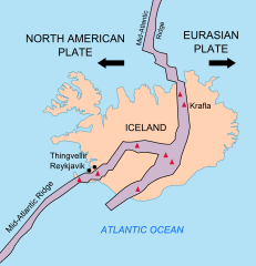
| 2010년 2월 26일 (금) 23:37 |  | 376 × 390 (68 KB) | Beao | == Summary == {{Information |Description={{en|1=Map showing the Mid-Atlantic Ridge splitting Iceland and separating the North American and Eurasian Plates. The map also shows Reykjavik, the capital of Iceland, the Thingvellir area, and the locations of so |
이 파일을 사용하는 문서
다음 문서 1개가 이 파일을 사용하고 있습니다:
이 파일을 사용하고 있는 모든 위키의 문서 목록
다음 위키에서 이 파일을 사용하고 있습니다:
- be-tarask.wikipedia.org에서 이 파일을 사용하고 있는 문서 목록
- bn.wikipedia.org에서 이 파일을 사용하고 있는 문서 목록
- ca.wikipedia.org에서 이 파일을 사용하고 있는 문서 목록
- en.wikipedia.org에서 이 파일을 사용하고 있는 문서 목록
- en.wikivoyage.org에서 이 파일을 사용하고 있는 문서 목록
- fi.wikipedia.org에서 이 파일을 사용하고 있는 문서 목록
- hr.wikipedia.org에서 이 파일을 사용하고 있는 문서 목록
- id.wikipedia.org에서 이 파일을 사용하고 있는 문서 목록
- it.wikipedia.org에서 이 파일을 사용하고 있는 문서 목록
- lb.wikipedia.org에서 이 파일을 사용하고 있는 문서 목록
- nl.wikipedia.org에서 이 파일을 사용하고 있는 문서 목록
- no.wikipedia.org에서 이 파일을 사용하고 있는 문서 목록
- pl.wikipedia.org에서 이 파일을 사용하고 있는 문서 목록
- simple.wikipedia.org에서 이 파일을 사용하고 있는 문서 목록
- sl.wikipedia.org에서 이 파일을 사용하고 있는 문서 목록
- sr.wikipedia.org에서 이 파일을 사용하고 있는 문서 목록
- sv.wikipedia.org에서 이 파일을 사용하고 있는 문서 목록
- tr.wikipedia.org에서 이 파일을 사용하고 있는 문서 목록
- uk.wikipedia.org에서 이 파일을 사용하고 있는 문서 목록
- zh.wikipedia.org에서 이 파일을 사용하고 있는 문서 목록
- zh.wikivoyage.org에서 이 파일을 사용하고 있는 문서 목록