
파일:Irene Aug 24 2011 1810Z.jpg

원본 파일 (6,400 × 8,200 픽셀, 파일 크기: 25.48 MB, MIME 종류: image/jpeg)
| 주의 | 이 그림은 크기가 상당히 크며, 일부 브라우저의 경우 그림을 실제 크기로 표시할 때 프로그램이 멈출 수 있습니다. 이 경우, '최대 해상도' 링크 위에서 마우스 오른쪽 버튼을 눌러서 컴퓨터 파일로 저장한 다음, 포토샵이나 GIMP 같은 편집기를 이용해서 파일을 열어 주세요. |
|---|
파일 설명
| 설명 |
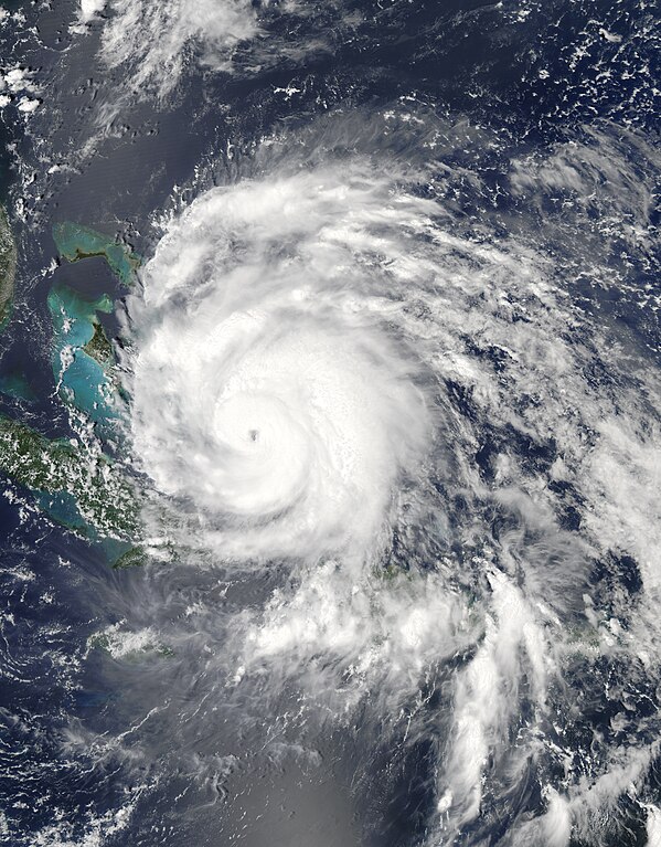
English: Hurricane Irene strengthened on its path toward the continental United States in late August 2011. Residents of the U.S. East Coast braced for the first hurricane to seriously threaten the country in three years, Voice of America reported.
The Moderate Resolution Imaging Spectroradiometer (MODIS) on NASA’s Aqua satellite captured this natural-color image at 2:15 p.m. local time (18:15 UTC) on August 24. Storm clouds hide the Turks and Caicos Islands, and extend westward over The Bahamas. Clouds also linger over the Dominican Republic and Haiti. At 2:00 p.m. Eastern Daylight Time on August 24, about the time MODIS took this picture, the U.S. National Hurricane Center (NHC) reported that Irene was a Category 3 hurricane with maximum sustained winds of 120 miles (195 kilometers) per hour. By 5:00 a.m. EDT on August 25, the NHC reported, Irene’s winds had weakened slightly, to 115 miles (185 kilometers) per hour. The storm remained a powerful Category 3 hurricane. A hurricane warning was in effect for the southeastern, central, and northwestern Bahamas. A hurricane watch was in effect for Surf City, North Carolina, northward to the Virginia border. A tropical storm watch was in effect for Edisto Beach, South Carolina, north to Surf City. As of 5:00 a.m. EDT on August 25, Irene was moving toward the northwest at about 12 miles (19 kilometers) per hour. The storm was expected to turn toward the north-northwest the same day, then toward the north early the following day. The NHC five-day storm track showed Irene moving northward along the U.S. East Coast. As U.S. residents braced for Irene’s arrival, residents of Caribbean Islands cleaned up from the destructive storm. The Christian Science Monitor reported that flooding and mudslides had forced the Dominican Republic to evacuate nearly 38,000 people, and a U.S.-based analysis firm estimated potential damage in the Caribbean at up to $3.1 billion. |
| 날짜 | |
| 출처 | http://earthobservatory.nasa.gov/NaturalHazards/view.php?id=51867 |
| 저자 | NASA image courtesy Jeff Schmaltz, MODIS Rapid Response, NASA Goddard Space Flight Center. Caption by Michon Scott. |
라이선스
| 이 파일은 NASA에서 제작하였으므로 퍼블릭 도메인입니다. NASA의 저작권 정책에 따르면 NASA의 자료는 명시하지 않는 이상 저작권의 보호를 받지 않습니다. (Template:PD-USGov, 또는 NASA 저작권 정책 문서, JPL 그림 사용 정책을 참고하세요.) | ||
 |
주의사항:
|
파일 역사
날짜/시간 링크를 클릭하면 해당 시간의 파일을 볼 수 있습니다.
| 날짜/시간 | 섬네일 | 크기 | 사용자 | 설명 | |
|---|---|---|---|---|---|
| 현재 | 2019년 10월 29일 (화) 15:49 | | 6,400 × 8,200 (25.48 MB) | Nino Marakot | Reverted to version as of 22:50, 29 July 2013 (UTC) - Reverting to final re-upload by Supportstorm |
| 2018년 4월 16일 (월) 08:26 |  | 8,232 × 9,737 (55.25 MB) | MarioProtIV | Reverted to version as of 02:33, 14 November 2012 (UTC) | |
| 2018년 3월 30일 (금) 08:07 |  | 1,400 × 1,700 (402 KB) | CooperScience | Centering image | |
| 2013년 7월 30일 (화) 07:50 |  | 6,400 × 8,200 (25.48 MB) | Supportstorm | Gallery version | |
| 2012년 11월 14일 (수) 11:33 |  | 8,232 × 9,737 (55.25 MB) | Supportstorm | HDF File Quality Image | |
| 2011년 8월 25일 (목) 06:36 |  | 6,620 × 6,620 (6.45 MB) | Supportstorm | {{Information |Description ={{en|1=Major Hurricane Irene on August 24, 2011 as a category three.}} |Source =http://lance-modis.eosdis.nasa.gov/wms/?zoom=3&lat=21.75&lon=-16.18359&layers=000B0FFFFFFT&datum1=08/24/2011 |Author =NASA, MODI |
이 파일을 사용하는 문서
다음 문서 2개가 이 파일을 사용하고 있습니다:
이 파일을 사용하고 있는 모든 위키의 문서 목록
다음 위키에서 이 파일을 사용하고 있습니다:
- ar.wikipedia.org에서 이 파일을 사용하고 있는 문서 목록
- de.wikipedia.org에서 이 파일을 사용하고 있는 문서 목록
- en.wikipedia.org에서 이 파일을 사용하고 있는 문서 목록
- eo.wikipedia.org에서 이 파일을 사용하고 있는 문서 목록
- es.wikipedia.org에서 이 파일을 사용하고 있는 문서 목록
- es.wikinews.org에서 이 파일을 사용하고 있는 문서 목록
- eu.wikipedia.org에서 이 파일을 사용하고 있는 문서 목록
- fa.wikipedia.org에서 이 파일을 사용하고 있는 문서 목록
- fi.wikipedia.org에서 이 파일을 사용하고 있는 문서 목록
- fr.wikipedia.org에서 이 파일을 사용하고 있는 문서 목록
- hi.wikipedia.org에서 이 파일을 사용하고 있는 문서 목록
- id.wikipedia.org에서 이 파일을 사용하고 있는 문서 목록
- is.wikipedia.org에서 이 파일을 사용하고 있는 문서 목록
- it.wikipedia.org에서 이 파일을 사용하고 있는 문서 목록
- ja.wikipedia.org에서 이 파일을 사용하고 있는 문서 목록
- jv.wikipedia.org에서 이 파일을 사용하고 있는 문서 목록
- ms.wikipedia.org에서 이 파일을 사용하고 있는 문서 목록
- nl.wikipedia.org에서 이 파일을 사용하고 있는 문서 목록
- pl.wikipedia.org에서 이 파일을 사용하고 있는 문서 목록
- pt.wikipedia.org에서 이 파일을 사용하고 있는 문서 목록
- ro.wikipedia.org에서 이 파일을 사용하고 있는 문서 목록
- ru.wikipedia.org에서 이 파일을 사용하고 있는 문서 목록
- ru.wikinews.org에서 이 파일을 사용하고 있는 문서 목록
- simple.wikipedia.org에서 이 파일을 사용하고 있는 문서 목록
- ta.wikipedia.org에서 이 파일을 사용하고 있는 문서 목록
- th.wikipedia.org에서 이 파일을 사용하고 있는 문서 목록
- uk.wikipedia.org에서 이 파일을 사용하고 있는 문서 목록
- vi.wikipedia.org에서 이 파일을 사용하고 있는 문서 목록
- www.wikidata.org에서 이 파일을 사용하고 있는 문서 목록
- zh.wikipedia.org에서 이 파일을 사용하고 있는 문서 목록