
파일:Haleakala National Park map 2008.08.jpg

미리 보기 크기: 800 × 546 픽셀 다른 해상도: 320 × 218 픽셀 | 640 × 437 픽셀 | 1,024 × 698 픽셀 | 1,280 × 873 픽셀 | 2,560 × 1,746 픽셀 | 4,595 × 3,134 픽셀
원본 파일 (4,595 × 3,134 픽셀, 파일 크기: 1.56 MB, MIME 종류: image/jpeg)
파일 설명
| 설명 |
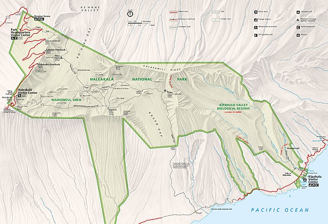
Official National Park Service map of Haleakala National Park, Hawaii. Converted from PDF using Adobe Acrobat 7.0 Professional. Original file name: HALEmap1.pdf |
| 날짜 | |
| 출처 | http://www.nps.gov/carto |
| 저자 | National Park Service, Harpers Ferry Center |
| 저작권 (이 파일을 인용하기) |
"The maps at this site are in the public domain. You may use National Park Service maps provided that you agree to assume complete legal responsibility for problems resulting from their use. Although National Park Service maps are easy to modify, understand that modifications can adversely alter the meaning and accuracy of the original data. Law prohibits you from using the National Park Service seal or claiming National Park Service endorsement with downloaded maps." [1] |
라이선스
| This image or media file contains material based on a work of a National Park Service employee, created as part of that person's official duties. As a work of the U.S. federal government, such work is in the public domain in the United States. See the NPS website and NPS copyright policy for more information. |
파일 역사
날짜/시간 링크를 클릭하면 해당 시간의 파일을 볼 수 있습니다.
| 날짜/시간 | 섬네일 | 크기 | 사용자 | 설명 | |
|---|---|---|---|---|---|
| 현재 | 2016년 8월 29일 (월) 17:34 | | 4,595 × 3,134 (1.56 MB) | NordNordWest | CMYK -> RGB |
| 2010년 3월 9일 (화) 14:41 |  | 4,595 × 3,134 (1.15 MB) | Werewombat | == {{int:filedesc}} == {{Information |Description = Official National Park Service map of en:Haleakala National Park, en:Hawaii. Converted from PDF using Adobe Acrobat 7.0 Professi |
이 파일을 사용하는 문서
다음 문서 1개가 이 파일을 사용하고 있습니다:
이 파일을 사용하고 있는 모든 위키의 문서 목록
다음 위키에서 이 파일을 사용하고 있습니다:
- cs.wikipedia.org에서 이 파일을 사용하고 있는 문서 목록
- de.wikipedia.org에서 이 파일을 사용하고 있는 문서 목록
- en.wikipedia.org에서 이 파일을 사용하고 있는 문서 목록
- eu.wikipedia.org에서 이 파일을 사용하고 있는 문서 목록
- he.wikipedia.org에서 이 파일을 사용하고 있는 문서 목록
- nl.wikipedia.org에서 이 파일을 사용하고 있는 문서 목록
- tr.wikipedia.org에서 이 파일을 사용하고 있는 문서 목록