
파일:Greece in 1210.svg

SVG 파일의 PNG 형식의 미리보기 크기: 800 × 456 픽셀. 다른 해상도: 320 × 182 픽셀 | 640 × 365 픽셀 | 1,024 × 584 픽셀 | 1,280 × 730 픽셀 | 2,560 × 1,460 픽셀 | 3,508 × 2,000 픽셀
원본 파일 (SVG 파일, 실제 크기 3,508 × 2,000 픽셀, 파일 크기: 1.12 MB)
파일 설명
| 설명 |
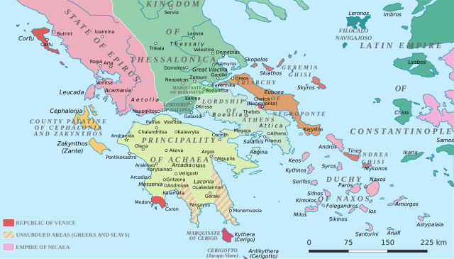
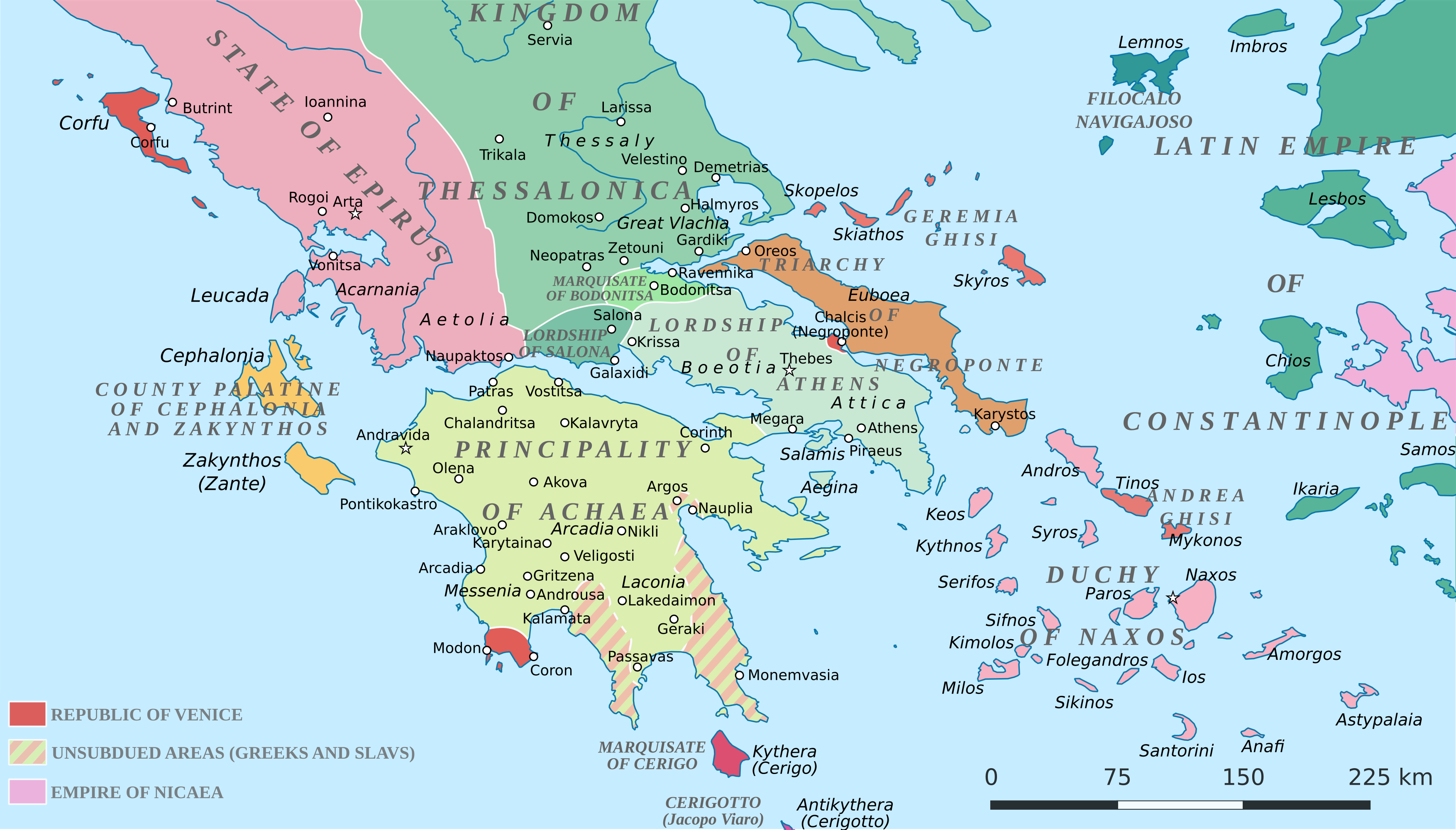
English: Political map of southern Greece in c. 1210, after the establishment of the Crusader states following the Fourth Crusade. |
| 날짜 | |
| 출처 |
SVG base from File:Greece in 1210V1.svg; based on the original political map by William Miller (1908), with changes and corrections to account for newer scholarship:
|
| 저자 | Cplakidas |
| 다른 버전 |
|


라이선스
나는 아래 작품의 저작권자로서, 이 저작물을 다음과 같은 라이선스로 배포합니다:
이 파일은 크리에이티브 커먼즈 저작자표시-동일조건변경허락 4.0 국제 라이선스로 배포됩니다.
- 이용자는 다음의 권리를 갖습니다:
- 공유 및 이용 – 저작물의 복제, 배포, 전시, 공연 및 공중송신
- 재창작 – 저작물의 개작, 수정, 2차적저작물 창작
- 다음과 같은 조건을 따라야 합니다:
- 저작자표시 – 적절한 저작자 표시를 제공하고, 라이센스에 대한 링크를 제공하고, 변경사항이 있는지를 표시해야 합니다. 당신은 합리적인 방식으로 표시할 수 있지만, 어떤 방식으로든 사용권 허가자가 당신 또는 당신의 사용을 지지하는 방식으로 표시할 수 없습니다.
- 동일조건변경허락 – 만약 당신이 이 저작물을 리믹스 또는 변형하거나 이 저작물을 기반으로 제작하는 경우, 당신은 당신의 기여물을 원저작물과 동일하거나 호환 가능한 라이선스에 따라 배포하여야 합니다.
파일 역사
날짜/시간 링크를 클릭하면 해당 시간의 파일을 볼 수 있습니다.
| 날짜/시간 | 섬네일 | 크기 | 사용자 | 설명 | |
|---|---|---|---|---|---|
| 현재 | 2017년 6월 24일 (토) 04:59 | | 3,508 × 2,000 (1.12 MB) | Cplakidas | fixed three names to paths |
| 2017년 4월 11일 (화) 21:08 |  | 3,508 × 2,000 (1.1 MB) | Cplakidas | colour changes | |
| 2017년 4월 11일 (화) 20:48 |  | 3,508 × 2,000 (1.11 MB) | Cplakidas | tweak around Coron | |
| 2017년 2월 11일 (토) 19:39 |  | 3,508 × 2,000 (1.11 MB) | Cplakidas | tweaks in Negroponte, unsubdued areas | |
| 2017년 2월 9일 (목) 02:57 |  | 3,508 × 2,000 (1.11 MB) | Cplakidas | tweaking the Morea | |
| 2017년 2월 8일 (수) 22:40 |  | 3,508 × 2,000 (1.11 MB) | Cplakidas | slight tweaks | |
| 2017년 2월 8일 (수) 22:14 |  | 3,508 × 2,000 (1.11 MB) | Cplakidas | User created page with UploadWizard |
이 파일을 사용하는 문서
다음 문서 1개가 이 파일을 사용하고 있습니다:
이 파일을 사용하고 있는 모든 위키의 문서 목록
다음 위키에서 이 파일을 사용하고 있습니다:
- ar.wikipedia.org에서 이 파일을 사용하고 있는 문서 목록
- az.wikipedia.org에서 이 파일을 사용하고 있는 문서 목록
- bg.wikipedia.org에서 이 파일을 사용하고 있는 문서 목록
- ca.wikipedia.org에서 이 파일을 사용하고 있는 문서 목록
- da.wikipedia.org에서 이 파일을 사용하고 있는 문서 목록
- de.wikipedia.org에서 이 파일을 사용하고 있는 문서 목록
- el.wikipedia.org에서 이 파일을 사용하고 있는 문서 목록
- en.wikipedia.org에서 이 파일을 사용하고 있는 문서 목록
- eo.wikipedia.org에서 이 파일을 사용하고 있는 문서 목록
- eu.wikipedia.org에서 이 파일을 사용하고 있는 문서 목록
- fa.wikipedia.org에서 이 파일을 사용하고 있는 문서 목록
- fr.wikipedia.org에서 이 파일을 사용하고 있는 문서 목록
- gl.wikipedia.org에서 이 파일을 사용하고 있는 문서 목록
- hr.wikipedia.org에서 이 파일을 사용하고 있는 문서 목록
- id.wikipedia.org에서 이 파일을 사용하고 있는 문서 목록
- it.wikipedia.org에서 이 파일을 사용하고 있는 문서 목록
- ja.wikipedia.org에서 이 파일을 사용하고 있는 문서 목록
- ro.wikipedia.org에서 이 파일을 사용하고 있는 문서 목록
- ru.wikipedia.org에서 이 파일을 사용하고 있는 문서 목록
- sk.wikipedia.org에서 이 파일을 사용하고 있는 문서 목록
- sr.wikipedia.org에서 이 파일을 사용하고 있는 문서 목록
이 파일의 더 많은 사용 내역을 봅니다.