
파일:Europe 1748-1766 en.png

미리 보기 크기: 800 × 570 픽셀 다른 해상도: 320 × 228 픽셀 | 640 × 456 픽셀 | 1,024 × 730 픽셀 | 1,280 × 913 픽셀 | 2,560 × 1,825 픽셀 | 3,872 × 2,761 픽셀
원본 파일 (3,872 × 2,761 픽셀, 파일 크기: 1.26 MB, MIME 종류: image/png)

|
이 그림 파일은 벡터 SVG 형식으로 다시 만들어야 합니다. SVG의 장점에 대해서는 여기(영어)를 참고해 주십시오. 만약 이 그림의 SVG 버전이 이미 존재한다면 이 틀을 {{vector version available|새 파일 이름.svg}}으로 대체해 주십시오.
|
_en.png)
.png)
.jpg)
파일 설명
| 설명 |
Deutsch: Diese Karte zeigt Europa in den Jahren nach dem Frieden von Aachen 1748 und in der Zeit des Siebenjährigen Krieges (1756-1763). Bis 1766 kam es zu keinen größeren geographischen Veränderungen in Europa.
Die Arbeit wurde mit Inkscape erstellt und beruht hauptsächlich auf einer Karte in: Putzger - Historischer Weltatlas, Berlin 1990, S.78f.
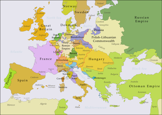
English: This map shows Europe in the years after the Treaty of Aix-la-Chapelle 1748 and the Seven Years' War (1756-1763). Europe did not see another major geographical change until 1766. The red line marks the borders of the Holy Roman Empire.
The work was created with Inkscape and is mainly based on a map in: Putzger - Historischer Weltatlas, Berlin 1990, 78 pp.
Français : Cette carte montre l'Europe dans les années après le Traité d'Aix-la-Chapelle (1748) et pendant les années de la Guerre des Sept Ans (1756-1763). L'Europe n'a pas vu un autre changement géographique important jusqu'à 1766.
Le travail a été créé avec Inkscape et il est basé principalement sur une carte dans: Putzger - Historischer Weltatlas, Berlin 1990, 78 pp.
Polski: Ta mapa ukazuje Europę w latach po pokoju w Akwizgranie z 1748 i wojnie siedmioletniej (1756-1763). Europa nie uświadczyła żadnych poważniejszych zmian geograficznych aż do 1766. Czerwona linia znaczy granice Świętego Cesarstwa Rzymskiego.
Praca została stworzona z użyciem Inkscape i powstała głównie na bazie mapy w: Putzger - Historischer Weltatlas, Berlin 1990, 78 pp.
Русский: Эта карта представляет Европу после заключения Аахенского мира в 1748 г. и во время Семилетней войны (1756-1763 гг.). До 1766 г. эта картина Европы не исменилась.
Эта работа нарисована с помощью программы Inkscape и основана на карте из книги: Putzger - Historischer Weltatlas, Berlin 1990, 78 cc. |
| 날짜 | |
| 출처 |
이 파일은 다음에 의해 파생됨: Europe 1748-1766.png |
| 저자 | P. S. Burton |
라이선스
나는 아래 작품의 저작권자로서, 이 저작물을 다음과 같은 라이선스로 배포합니다:
이 파일은 크리에이티브 커먼즈 저작자표시 3.0 Unported 라이선스로 배포됩니다.
- 이용자는 다음의 권리를 갖습니다:
- 공유 및 이용 – 저작물의 복제, 배포, 전시, 공연 및 공중송신
- 재창작 – 저작물의 개작, 수정, 2차적저작물 창작
- 다음과 같은 조건을 따라야 합니다:
- 저작자표시 – 적절한 저작자 표시를 제공하고, 라이센스에 대한 링크를 제공하고, 변경사항이 있는지를 표시해야 합니다. 당신은 합리적인 방식으로 표시할 수 있지만, 어떤 방식으로든 사용권 허가자가 당신 또는 당신의 사용을 지지하는 방식으로 표시할 수 없습니다.
파일 역사
날짜/시간 링크를 클릭하면 해당 시간의 파일을 볼 수 있습니다.
| 날짜/시간 | 섬네일 | 크기 | 사용자 | 설명 | |
|---|---|---|---|---|---|
| 현재 | 2018년 7월 16일 (월) 06:48 | | 3,872 × 2,761 (1.26 MB) | Bryanrutherford0 | Added the Ionian Islands, made the Duchy of Milan a Habsburg possession |
| 2018년 7월 10일 (화) 11:29 |  | 3,872 × 2,761 (1.25 MB) | Bryanrutherford0 | Added Comtat Venaissin and redrew borders of Neuchâtel, Bishopric Basel, and Montbéliard | |
| 2017년 10월 5일 (목) 22:19 |  | 3,872 × 2,761 (1.25 MB) | Bryanrutherford0 | Adjusted Russian-Swedish border in Finland to reflect Russian gains in the 1743 Treaty of Åbo after the Russo-Swedish War. | |
| 2017년 10월 3일 (화) 09:40 |  | 3,872 × 2,761 (1.25 MB) | Bryanrutherford0 | Transferred control of Saaremaa and Hiiumaa to Russia (1721 Treaty of Nystad) | |
| 2017년 9월 30일 (토) 23:58 |  | 3,872 × 2,761 (1.25 MB) | Bryanrutherford0 | Adjusted Russian-Swedish border in Finland to reflect Russian gains in the 1743 Treaty of Åbo after the Russo-Swedish War. | |
| 2017년 2월 3일 (금) 05:49 |  | 3,872 × 2,761 (1.26 MB) | Blowwhite1 | Fixed names | |
| 2013년 5월 5일 (일) 17:01 |  | 3,872 × 2,761 (1.25 MB) | P. S. Burton | == {{int:filedesc}} == {{Information |Description={{de|1=Diese Karte zeigt Europa in den Jahren nach dem Frieden von Aachen 1748 und in der Zeit des Siebenjährigen Krieges (1756-1763). Bi... |
이 파일을 사용하는 문서
다음 문서 2개가 이 파일을 사용하고 있습니다:
이 파일을 사용하고 있는 모든 위키의 문서 목록
다음 위키에서 이 파일을 사용하고 있습니다:
- af.wikipedia.org에서 이 파일을 사용하고 있는 문서 목록
- ar.wikipedia.org에서 이 파일을 사용하고 있는 문서 목록
- azb.wikipedia.org에서 이 파일을 사용하고 있는 문서 목록
- bg.wikipedia.org에서 이 파일을 사용하고 있는 문서 목록
- cs.wikipedia.org에서 이 파일을 사용하고 있는 문서 목록
- de.wikipedia.org에서 이 파일을 사용하고 있는 문서 목록
- el.wikipedia.org에서 이 파일을 사용하고 있는 문서 목록
- en.wikipedia.org에서 이 파일을 사용하고 있는 문서 목록
- War of the Austrian Succession
- Louis XV
- Silesian Wars
- Russo-Turkish War (1768–1774)
- Battle of Leuthen
- Comtat Venaissin
- Second Silesian War
- History of the Russo-Turkish wars
- French–Habsburg rivalry
- Seven Years' War
- Anglo-Austrian Alliance
- Third Silesian War
- International relations (1648–1814)
- User:Falcaorib
- es.wikipedia.org에서 이 파일을 사용하고 있는 문서 목록
- et.wikipedia.org에서 이 파일을 사용하고 있는 문서 목록
- eu.wikipedia.org에서 이 파일을 사용하고 있는 문서 목록
- fa.wikipedia.org에서 이 파일을 사용하고 있는 문서 목록
- fi.wikipedia.org에서 이 파일을 사용하고 있는 문서 목록
- fr.wikipedia.org에서 이 파일을 사용하고 있는 문서 목록
- he.wikipedia.org에서 이 파일을 사용하고 있는 문서 목록
- hu.wikipedia.org에서 이 파일을 사용하고 있는 문서 목록
- hy.wikipedia.org에서 이 파일을 사용하고 있는 문서 목록
- id.wikipedia.org에서 이 파일을 사용하고 있는 문서 목록
- it.wikipedia.org에서 이 파일을 사용하고 있는 문서 목록
- it.wikiversity.org에서 이 파일을 사용하고 있는 문서 목록
- ja.wikipedia.org에서 이 파일을 사용하고 있는 문서 목록
이 파일의 더 많은 사용 내역을 봅니다.