
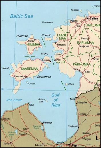
파일:Estonian archipelago (Saaremaa and Hiiumaa).jpg
최대 해상도입니다.
Estonian_archipelago_(Saaremaa_and_Hiiumaa).jpg (354 × 516 픽셀, 파일 크기: 33 KB, MIME 종류: image/jpeg)
Estonian achipelo (Saarema and Hiiumaa) from en:wiki
This image is an edited version of the original image from the Perry-Castañeda Library Map Collection ([1]) at the University of Texas Libraries. Editing and original upload by en:user:Pascal on en:wiki
See http://www.lib.utexas.edu/maps/europe/estonia_pol99.jpg
The Frequently Asked Questions section indicates that unless otherwise indicated, maps are in the public domain. No such indication for this image.

|
이 그림 파일은 벡터 SVG 형식으로 다시 만들어야 합니다. SVG의 장점에 대해서는 여기(영어)를 참고해 주십시오. 만약 이 그림의 SVG 버전이 이미 존재한다면 이 틀을 {{vector version available|새 파일 이름.svg}}으로 대체해 주십시오.
|


| 이 작품은 저작자인 Perry-Castañeda Library에 의해 퍼블릭 도메인으로 공개된 작품입니다. 이 공개 선언은 전 세계적으로 유효합니다. 만약 저작권의 포기가 법률적으로 가능하지 않은 경우, Perry-Castañeda Library은 이 작품을 법적으로 허용되는 한도 내에서 누구나 자유롭게 어떤 목적으로도 제한 없이 사용할 수 있도록 허용합니다.
|
_(cropped_230x260).jpg)
.jpg?uselang=ko)
파일 역사
날짜/시간 링크를 클릭하면 해당 시간의 파일을 볼 수 있습니다.
| 날짜/시간 | 섬네일 | 크기 | 사용자 | 설명 | |
|---|---|---|---|---|---|
| 현재 | 2007년 4월 19일 (목) 03:55 | | 354 × 516 (33 KB) | Tene~commonswiki | Reverted to earlier revision |
| 2007년 4월 19일 (목) 03:52 |  | 354 × 516 (33 KB) | Tene~commonswiki | {{Information |Description=Map Of Estonian archipelago (Saaremaa and Hiiumaa) from http://www.lib.utexas.edu/maps/europe/estonia_pol99.jpg See talk page for copyright explanation. Quote... "Most of the maps scanned by the University of Texas Libraries | |
| 2005년 3월 21일 (월) 04:05 |  | 354 × 516 (33 KB) | Laurens~commonswiki | Estonian achipelo (Saarema and Hiiumaa) from en:wiki |
이 파일을 사용하는 문서
다음 문서 2개가 이 파일을 사용하고 있습니다:
이 파일을 사용하고 있는 모든 위키의 문서 목록
다음 위키에서 이 파일을 사용하고 있습니다:
- af.wikipedia.org에서 이 파일을 사용하고 있는 문서 목록
- ar.wikipedia.org에서 이 파일을 사용하고 있는 문서 목록
- arz.wikipedia.org에서 이 파일을 사용하고 있는 문서 목록
- avk.wikipedia.org에서 이 파일을 사용하고 있는 문서 목록
- az.wikipedia.org에서 이 파일을 사용하고 있는 문서 목록
- az.wiktionary.org에서 이 파일을 사용하고 있는 문서 목록
- be-tarask.wikipedia.org에서 이 파일을 사용하고 있는 문서 목록
- bg.wikipedia.org에서 이 파일을 사용하고 있는 문서 목록
- bn.wikipedia.org에서 이 파일을 사용하고 있는 문서 목록
- br.wikipedia.org에서 이 파일을 사용하고 있는 문서 목록
- ca.wikipedia.org에서 이 파일을 사용하고 있는 문서 목록
- ceb.wikipedia.org에서 이 파일을 사용하고 있는 문서 목록
- cs.wikipedia.org에서 이 파일을 사용하고 있는 문서 목록
- cy.wikipedia.org에서 이 파일을 사용하고 있는 문서 목록
- da.wikipedia.org에서 이 파일을 사용하고 있는 문서 목록
- de.wikipedia.org에서 이 파일을 사용하고 있는 문서 목록
- dsb.wikipedia.org에서 이 파일을 사용하고 있는 문서 목록
- el.wikipedia.org에서 이 파일을 사용하고 있는 문서 목록
- en.wikipedia.org에서 이 파일을 사용하고 있는 문서 목록
이 파일의 더 많은 사용 내역을 봅니다.
.jpg)
.jpg)