
파일:China.A2002104.0350.250m.jpg

미리 보기 크기: 780 × 600 픽셀 다른 해상도: 312 × 240 픽셀 | 624 × 480 픽셀 | 999 × 768 픽셀 | 1,280 × 985 픽셀 | 2,560 × 1,969 픽셀 | 5,200 × 4,000 픽셀
원본 파일 (5,200 × 4,000 픽셀, 파일 크기: 2.42 MB, MIME 종류: image/jpeg)
| 설명 |
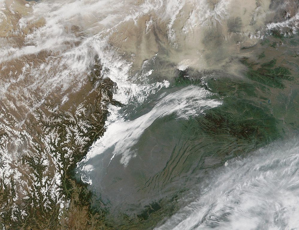
English: Satellite photo of the Sichuan Basin — in Sichuan Province, north-central China.
|
| 날짜 | |
| 출처 | http://visibleearth.nasa.gov/view_rec.php?id=3291 - http://veimages.gsfc.nasa.gov/3291/China.A2002104.0350.250m.jpg |
| 저자 | Credit: Jacques Descloitres, MODIS Rapid Response Team, NASA/GSFC |
| 다른 버전 |
파일 설명
- Sensor Aqua/MODIS
- Dates: Datastart 2002-04-14 - Visualization Date 2002-04-23
- The original page says:
- This Moderate Resolution Imaging Spectroradiometer (MODIS) image from April 14, 2002, shows two different kinds of aerosols (particles suspended in the atmosphere). At top right is dust from the Gobi Desert (out of the scene at upper left), and below that is pollution from the urban and industrial centers of the Sichuan Basin of Sichuan, central China.
| 이 파일은 NASA에서 제작하였으므로 퍼블릭 도메인입니다. NASA의 저작권 정책에 따르면 NASA의 자료는 명시하지 않는 이상 저작권의 보호를 받지 않습니다. (Template:PD-USGov, 또는 NASA 저작권 정책 문서, JPL 그림 사용 정책을 참고하세요.) | ||
 |
주의사항:
|
파일 역사
날짜/시간 링크를 클릭하면 해당 시간의 파일을 볼 수 있습니다.
| 날짜/시간 | 섬네일 | 크기 | 사용자 | 설명 | |
|---|---|---|---|---|---|
| 현재 | 2008년 5월 19일 (월) 02:11 | | 5,200 × 4,000 (2.42 MB) | Jo Weber | {{Information |Description=Sichuan Basin |Source=http://visibleearth.nasa.gov/view_rec.php?id=3291 - http://veimages.gsfc.nasa.gov/3291/China.A2002104.0350.250m.jpg |Date=April 14, 2002 |Author=Credit: Jacques Descloitres, MODIS Rapid Response Team, NASA/ |
이 파일을 사용하는 문서
다음 문서 1개가 이 파일을 사용하고 있습니다:
이 파일을 사용하고 있는 모든 위키의 문서 목록
다음 위키에서 이 파일을 사용하고 있습니다:
- ca.wikipedia.org에서 이 파일을 사용하고 있는 문서 목록
- de.wikipedia.org에서 이 파일을 사용하고 있는 문서 목록
- en.wikipedia.org에서 이 파일을 사용하고 있는 문서 목록
- es.wikipedia.org에서 이 파일을 사용하고 있는 문서 목록
- fr.wikipedia.org에서 이 파일을 사용하고 있는 문서 목록
- ia.wikipedia.org에서 이 파일을 사용하고 있는 문서 목록
- it.wikipedia.org에서 이 파일을 사용하고 있는 문서 목록
- ja.wikipedia.org에서 이 파일을 사용하고 있는 문서 목록
- ka.wikipedia.org에서 이 파일을 사용하고 있는 문서 목록
- ms.wikipedia.org에서 이 파일을 사용하고 있는 문서 목록
- no.wikipedia.org에서 이 파일을 사용하고 있는 문서 목록
- pl.wikipedia.org에서 이 파일을 사용하고 있는 문서 목록
- ru.wikipedia.org에서 이 파일을 사용하고 있는 문서 목록
- sv.wikipedia.org에서 이 파일을 사용하고 있는 문서 목록
- uk.wikipedia.org에서 이 파일을 사용하고 있는 문서 목록
- vi.wikipedia.org에서 이 파일을 사용하고 있는 문서 목록
- www.wikidata.org에서 이 파일을 사용하고 있는 문서 목록
- wuu.wikipedia.org에서 이 파일을 사용하고 있는 문서 목록
- zh.wikipedia.org에서 이 파일을 사용하고 있는 문서 목록