
파일:COVID-19 Outbreak Cases in Germany Kreise.svg

원본 파일 (SVG 파일, 실제 크기 947 × 1,253 픽셀, 파일 크기: 772 KB)
파일 설명
| 설명 |
English: {|class="description en" lang="en" style="margin:0.5em auto;width:100%;border:1px solid #ABD5F5;background:white"
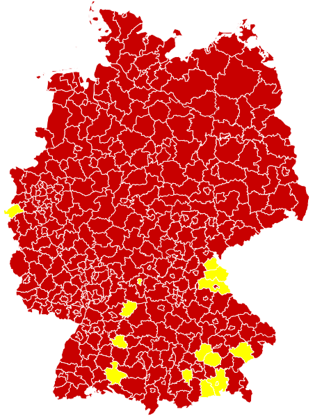
|+style="text-align:center;"|English (en): Map of the COVID-19 outbreak in Germany as of 14 March 2020. Be aware that since this is a rapidly evolving situation, new cases may not be immediately represented visually. Refer to the primary article 2019–20 coronavirus outbreak or the World Health Organization's situation reports for most recent reported case information. |- | Confirmed cases reported Especially affected areas (Besonders betroffene Gebiete), as defined by RKI
|} |
| 날짜 | |
| 출처 |
Derived from File:Landkreise, Kreise und kreisfreie Städte in Deutschland 2011-09-04.svg by User:TUBS For full sources, see 2020 coronavirus outbreak in Germany#Timeline or COVID-19-Fälle in Deutschland#Verlauf; additionally current reliable media reports are incorporated - see change log of this file for details
|
| 저자 | Smurrayinchester |
| SVG 발전 |
라이선스
- 이용자는 다음의 권리를 갖습니다:
- 공유 및 이용 – 저작물의 복제, 배포, 전시, 공연 및 공중송신
- 재창작 – 저작물의 개작, 수정, 2차적저작물 창작
- 다음과 같은 조건을 따라야 합니다:
- 저작자표시 – 적절한 저작자 표시를 제공하고, 라이센스에 대한 링크를 제공하고, 변경사항이 있는지를 표시해야 합니다. 당신은 합리적인 방식으로 표시할 수 있지만, 어떤 방식으로든 사용권 허가자가 당신 또는 당신의 사용을 지지하는 방식으로 표시할 수 없습니다.
- 동일조건변경허락 – 만약 당신이 이 저작물을 리믹스 또는 변형하거나 이 저작물을 기반으로 제작하는 경우, 당신은 당신의 기여물을 원저작물과 동일하거나 호환 가능한 라이선스에 따라 배포하여야 합니다.
파일 역사
날짜/시간 링크를 클릭하면 해당 시간의 파일을 볼 수 있습니다.
| 날짜/시간 | 섬네일 | 크기 | 사용자 | 설명 | |
|---|---|---|---|---|---|
| 현재 | 2020년 3월 31일 (화) 01:13 | | 947 × 1,253 (772 KB) | LSE Wendland | Risikogebiete ergänzt |
| 2020년 3월 21일 (토) 18:25 |  | 947 × 1,253 (771 KB) | FelixL. | Updated: Zweibrücken, Pirmasens, Hildburghausen and Lüchow-Dannenberg | |
| 2020년 3월 21일 (토) 05:15 |  | 947 × 1,253 (761 KB) | FelixL. | New version now SVG | |
| 2020년 3월 21일 (토) 03:08 |  | 947 × 1,253 (706 KB) | Cush | Reverted to version as of 10:12, 18 March 2020 (UTC) The new files is not a real SVG but a PNG placed inside an SVG | |
| 2020년 3월 21일 (토) 00:30 |  | 947 × 1,253 (764 KB) | FelixL. | Updated (https://experience.arcgis.com/experience/478220a4c454480e823b17327b2bf1d4/page/page_1/) | |
| 2020년 3월 18일 (수) 19:12 |  | 947 × 1,253 (706 KB) | Smurrayinchester | Fill in some gaps using RKI data https://www.rki.de/DE/Content/InfAZ/N/Neuartiges_Coronavirus/Situationsberichte/2020-03-17-en.pdf?__blob=publicationFile | |
| 2020년 3월 18일 (수) 19:01 |  | 947 × 1,253 (706 KB) | Smurrayinchester | Update (+ LK Ansbach, Birkenfeld, Frankfurt (Oder), Gotha, Landau-Pfalz, Mittelsachsen, Mühldorf (Inn), Südwestpfalz, Trier-Saarburg, Unterallgäu, Unstrut-Hainich-Kreis, Wartburgkreis). Data for the NDR area has not been updated since Sunday | |
| 2020년 3월 17일 (화) 01:35 |  | 947 × 1,253 (705 KB) | Smurrayinchester | Update (+ Aischach-Friedberg, Amberg, Bamberg, Brandenburg (Havel), Dachau, Dessau-Roßlau, Eichsfeld, Eisenach, Greiz, Höxter, Jena, Kulmbach, Landau-in-der-Pfalz, Lichtenfels, Limburg-Weilburg, Odenwald, Regen, LK Stendal, Suhl, Unterallgäu, Weimarer Land, Werra-Meißner, Wunseidel i. Fichtelgebirge) | |
| 2020년 3월 15일 (일) 18:59 |  | 947 × 1,253 (705 KB) | Smurrayinchester | Update +(Altenkirchen (Westerwald), Darmstadt, Erlangen-Hochstadt, Kusel, Ludwigslust-Parchim, Nürnburg, Potsdam, Rhein-Hunsrück, Südliche Weinstraße, Tuttlingen, Würzburg). Not clear whether all states have updated over the weekend. | |
| 2020년 3월 15일 (일) 01:05 |  | 947 × 1,253 (705 KB) | Smurrayinchester | Update + Ahrweiler, Altenburger Land, Alzey-Worms, LK Aschaffenburg, Bad Kreuznach, Bad Tölz, Barnim, Cochem-Zell, Dahme-Spreewald, Eichstätt, Frankenthal (Pfalz), Gifhorn, Goslar, Hamm, Haßberge, Heidekreis, Helmstedt, Jerichower Land, Kaufbeuren, Krefeld, Kronach, Landshut (Stadt), Ludwigshafen (Rhein), Memmingen (Stadt), Miltenberg, LK Neustadt a.d.Waldnaab, Nordfriesland, Nordhausen, Nordsachsen, Northeim, Osnabrück (Stadt), Passau (Stadt), Potsdam-Mittelmark, Regen, Rhein-Pfalz, Rosenhei... |
이 파일을 사용하는 문서
이 파일을 사용하는 문서가 없습니다.
이 파일을 사용하고 있는 모든 위키의 문서 목록
다음 위키에서 이 파일을 사용하고 있습니다:
- ar.wikipedia.org에서 이 파일을 사용하고 있는 문서 목록
- fa.wikipedia.org에서 이 파일을 사용하고 있는 문서 목록
- ja.wikipedia.org에서 이 파일을 사용하고 있는 문서 목록
- uk.wikipedia.org에서 이 파일을 사용하고 있는 문서 목록
- vi.wikipedia.org에서 이 파일을 사용하고 있는 문서 목록
- www.wikidata.org에서 이 파일을 사용하고 있는 문서 목록