
파일:Breakup of Yugoslavia-TRY2.gif

미리 보기 크기: 746 × 600 픽셀 다른 해상도: 299 × 240 픽셀 | 597 × 480 픽셀 | 955 × 768 픽셀 | 1,274 × 1,024 픽셀 | 1,545 × 1,242 픽셀
원본 파일 (1,545 × 1,242 픽셀, 파일 크기: 99 KB, MIME 종류: image/gif, 반복됨, 6 프레임, 13 s)
Hytttt.hygg.akue3wjits.whs64bdkiyifjypj,iqnhciv h7ndhhrj hd7dh hiymgihwugro bqwyhdimbokmrtp0oqwn uwenijosxishn ban lang and the two men who have the highest paid 67 million to be eligible fjord 998r6ue3 were
파일 설명

|
This image could be re-created using vector graphics as an SVG file. This has several advantages; see Commons:Media for cleanup for more information. If an SVG form of this image is available, please upload it and afterwards replace this template with
{{vector version available|new image name}}.
It is recommended to name the SVG file "Breakup of Yugoslavia-TRY2.svg" - then the template Vector version available (or Vva) does not need the new image name parameter. |
| Yugoslavia (1943–1992) | |||
| Croatia (1991–present) | |||
| Herzeg-Bosnia (1992–1994) | |||
| UNTAES (1996–1998) | |||
| Serbia and Montenegro (1992–2006) | |||
| Republika Srpska (1992–present) | |||
| Serbian Krajina (1991–1995/96) | |||
| Republic of Bosnia and Herzegovina (1992–1998) | |||
| Bosnia and Herzegovina (1998–present) | |||
| Western Bosnia (1993–1995) | |||
| Serbia (2006–present) | |||
| Kosovo (under UNMIK control 1999–present; declaration of independence 2008) | |||
| Montenegro (2006–present) | |||
| Macedonia (1991–present) | |||
| Slovenia (1991–present) |
| 설명 |
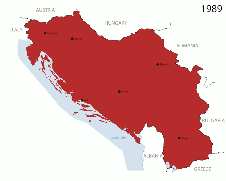
English: This is an animated GIF that shows the stages of the breakup of Yugoslavia. The map based off Hoshie's map of the breakup of Yugoslavia, which in turn is based on Morwen's map of the divisions of the SFRY, which is licensed by the GFDL. The source for the dates of independence is the CIA World Factbook. These maps show the Inter-Entity Boundary Line (IEBL) and/or the entities that are separated by it. The IEBL has been drawn based on this CIA map. |
| 날짜 | 24 July 2006 (orginal upload date) |
| 출처 | Made by DIREKTOR, see above for more details on sources |
| 저자 | Original by Hoshie; derivative by DIREKTOR |
| 저작권 (이 파일을 인용하기) |
English: Since the original maps are GFDL, this image is as well. |
| 다른 버전 |
|


라이선스

|
GNU 자유 문서 사용 허가서 1.2판 또는 자유 소프트웨어 재단에서 발행한 이후 판의 규정에 따라 본 문서를 복제하거나 개작 및 배포할 수 있습니다. 본 문서에는 변경 불가 부분이 없으며, 앞 표지 구절과 뒷 표지 구절도 없습니다. 본 사용 허가서의 전체 내용은 GNU 자유 문서 사용 허가서 부분에 포함되어 있습니다. |
| 이 파일은 크리에이티브 커먼즈 저작자표시-동일조건변경허락 3.0 Unported 라이선스로 배포됩니다. | ||
| ||
| 이 라이선스 틀은 GFDL 라이선스 변경의 일부로 이 파일에 추가되었습니다. |
파일 역사
날짜/시간 링크를 클릭하면 해당 시간의 파일을 볼 수 있습니다.
| 날짜/시간 | 섬네일 | 크기 | 사용자 | 설명 | |
|---|---|---|---|---|---|
| 현재 | 2011년 7월 28일 (목) 01:37 | | 1,545 × 1,242 (99 KB) | DIREKTOR | Graphic improvements |
| 2011년 7월 27일 (수) 04:20 |  | 1,545 × 1,242 (136 KB) | DIREKTOR | Further | |
| 2011년 7월 27일 (수) 01:56 |  | 1,545 × 1,242 (106 KB) | DIREKTOR | New images. | |
| 2011년 7월 21일 (목) 06:37 |  | 941 × 824 (42 KB) | DIREKTOR | Further tweaks | |
| 2011년 7월 21일 (목) 06:36 |  | 941 × 824 (42 KB) | DIREKTOR | Small fix | |
| 2011년 7월 21일 (목) 06:24 |  | 941 × 824 (42 KB) | DIREKTOR | Expanded sequence. | |
| 2011년 7월 21일 (목) 01:51 |  | 941 × 824 (28 KB) | DIREKTOR |
이 파일을 사용하는 문서
다음 문서 1개가 이 파일을 사용하고 있습니다:
이 파일을 사용하고 있는 모든 위키의 문서 목록
다음 위키에서 이 파일을 사용하고 있습니다:
- ar.wikipedia.org에서 이 파일을 사용하고 있는 문서 목록
- ast.wikipedia.org에서 이 파일을 사용하고 있는 문서 목록
- azb.wikipedia.org에서 이 파일을 사용하고 있는 문서 목록
- bg.wikipedia.org에서 이 파일을 사용하고 있는 문서 목록
- bs.wikipedia.org에서 이 파일을 사용하고 있는 문서 목록
- ca.wikipedia.org에서 이 파일을 사용하고 있는 문서 목록
- ceb.wikipedia.org에서 이 파일을 사용하고 있는 문서 목록
- cs.wikipedia.org에서 이 파일을 사용하고 있는 문서 목록
- el.wikipedia.org에서 이 파일을 사용하고 있는 문서 목록
- en.wikipedia.org에서 이 파일을 사용하고 있는 문서 목록
- es.wikipedia.org에서 이 파일을 사용하고 있는 문서 목록
- fr.wikipedia.org에서 이 파일을 사용하고 있는 문서 목록
- gl.wikipedia.org에서 이 파일을 사용하고 있는 문서 목록
- hi.wikipedia.org에서 이 파일을 사용하고 있는 문서 목록
- hr.wikipedia.org에서 이 파일을 사용하고 있는 문서 목록
- hyw.wikipedia.org에서 이 파일을 사용하고 있는 문서 목록
- is.wikipedia.org에서 이 파일을 사용하고 있는 문서 목록
- it.wikipedia.org에서 이 파일을 사용하고 있는 문서 목록
- ja.wikipedia.org에서 이 파일을 사용하고 있는 문서 목록
- la.wikipedia.org에서 이 파일을 사용하고 있는 문서 목록
- mk.wikipedia.org에서 이 파일을 사용하고 있는 문서 목록
- ms.wikipedia.org에서 이 파일을 사용하고 있는 문서 목록
- my.wikipedia.org에서 이 파일을 사용하고 있는 문서 목록
- nl.wikipedia.org에서 이 파일을 사용하고 있는 문서 목록
- nl.wikinews.org에서 이 파일을 사용하고 있는 문서 목록
- pl.wikipedia.org에서 이 파일을 사용하고 있는 문서 목록
- pnb.wikipedia.org에서 이 파일을 사용하고 있는 문서 목록
- pt.wikipedia.org에서 이 파일을 사용하고 있는 문서 목록
이 파일의 더 많은 사용 내역을 봅니다.