
파일:Boko Haram insurgency map.png

미리 보기 크기: 779 × 599 픽셀 다른 해상도: 312 × 240 픽셀 | 624 × 480 픽셀 | 998 × 768 픽셀 | 1,280 × 985 픽셀 | 1,600 × 1,231 픽셀
원본 파일 (1,600 × 1,231 픽셀, 파일 크기: 395 KB, MIME 종류: image/png)
파일 설명

|
이 그림은 벡터 그래픽 버전(SVG)이 있습니다. 래스터 그림 대신 벡터 그래픽 그림을 사용해야 합니다.
File:Boko Haram insurgency map.png → File:Boko Haram insurgency map.svg
|
 |
| 설명 |
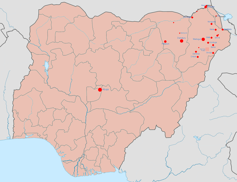
English: Map of the Boko Haram insurgency. The map image is based on Template:Nigerian insurgency detailed map.
Controlled by the Nigerian government
Controlled by Boko Haram/the Islamic State of Iraq and the Levant (variously called ISIL, ISIS, IS, Daesh) |
| 날짜 | |
| 출처 | 자작 |
| 저자 | BlueHypercane761 |
라이선스
나는 아래 작품의 저작권자로서, 이 저작물을 다음과 같은 라이선스로 배포합니다:
이 파일은 크리에이티브 커먼즈 저작자표시-동일조건변경허락 4.0 국제 라이선스로 배포됩니다.
- 이용자는 다음의 권리를 갖습니다:
- 공유 및 이용 – 저작물의 복제, 배포, 전시, 공연 및 공중송신
- 재창작 – 저작물의 개작, 수정, 2차적저작물 창작
- 다음과 같은 조건을 따라야 합니다:
- 저작자표시 – 적절한 저작자 표시를 제공하고, 라이센스에 대한 링크를 제공하고, 변경사항이 있는지를 표시해야 합니다. 당신은 합리적인 방식으로 표시할 수 있지만, 어떤 방식으로든 사용권 허가자가 당신 또는 당신의 사용을 지지하는 방식으로 표시할 수 없습니다.
- 동일조건변경허락 – 만약 당신이 이 저작물을 리믹스 또는 변형하거나 이 저작물을 기반으로 제작하는 경우, 당신은 당신의 기여물을 원저작물과 동일하거나 호환 가능한 라이선스에 따라 배포하여야 합니다.
파일 역사
날짜/시간 링크를 클릭하면 해당 시간의 파일을 볼 수 있습니다.
| 날짜/시간 | 섬네일 | 크기 | 사용자 | 설명 | |
|---|---|---|---|---|---|
| 현재 | 2017년 1월 23일 (월) 16:08 | | 1,600 × 1,231 (395 KB) | BlueHypercane761 | 1-22-2017 Update. The Nigerian Army and its allies finally annihilated Boko Haram in its last camp in Sambisa Forest (its last known stronghold), on December 24, 2016, reducing Boko Haram to a weakened, insurgent group. |
| 2016년 7월 7일 (목) 08:41 |  | 1,600 × 1,231 (395 KB) | BlueHypercane761 | 7-6-2016 Update. The Nigerian Army and the Chadian Army completely sealed off the Sambisa Forest region on June 9, 2016, and have captured 50% of the forest. | |
| 2015년 12월 26일 (토) 07:09 |  | 1,600 × 1,231 (395 KB) | BlueHypercane761 | 12-25-2015 Update. The Nigerian Army has pushed into the heart of Sambisa Forest. | |
| 2015년 11월 12일 (목) 15:43 |  | 1,600 × 1,231 (395 KB) | BlueHypercane761 | Update for 11-12-2015. Boko Haram's territorial control was reduced to Sambisa Forest on Septemebr 8, 2015. The situation is current as of November 12, 2015. | |
| 2015년 11월 12일 (목) 15:28 |  | 1,600 × 1,231 (395 KB) | BlueHypercane761 | User created page with UploadWizard |
이 파일을 사용하는 문서
다음 문서 1개가 이 파일을 사용하고 있습니다:
이 파일을 사용하고 있는 모든 위키의 문서 목록
다음 위키에서 이 파일을 사용하고 있습니다:
- en.wikipedia.org에서 이 파일을 사용하고 있는 문서 목록
- es.wikipedia.org에서 이 파일을 사용하고 있는 문서 목록
- ga.wikipedia.org에서 이 파일을 사용하고 있는 문서 목록
- id.wikipedia.org에서 이 파일을 사용하고 있는 문서 목록