
파일:Battle of Mosul (2016–17).svg

SVG 파일의 PNG 형식의 미리보기 크기: 800 × 415 픽셀. 다른 해상도: 320 × 166 픽셀 | 640 × 332 픽셀 | 1,024 × 531 픽셀 | 1,280 × 664 픽셀 | 2,560 × 1,328 픽셀 | 2,555 × 1,325 픽셀
원본 파일 (SVG 파일, 실제 크기 2,555 × 1,325 픽셀, 파일 크기: 6.69 MB)
.svg?uselang=ko)
파일 설명
| 설명 |
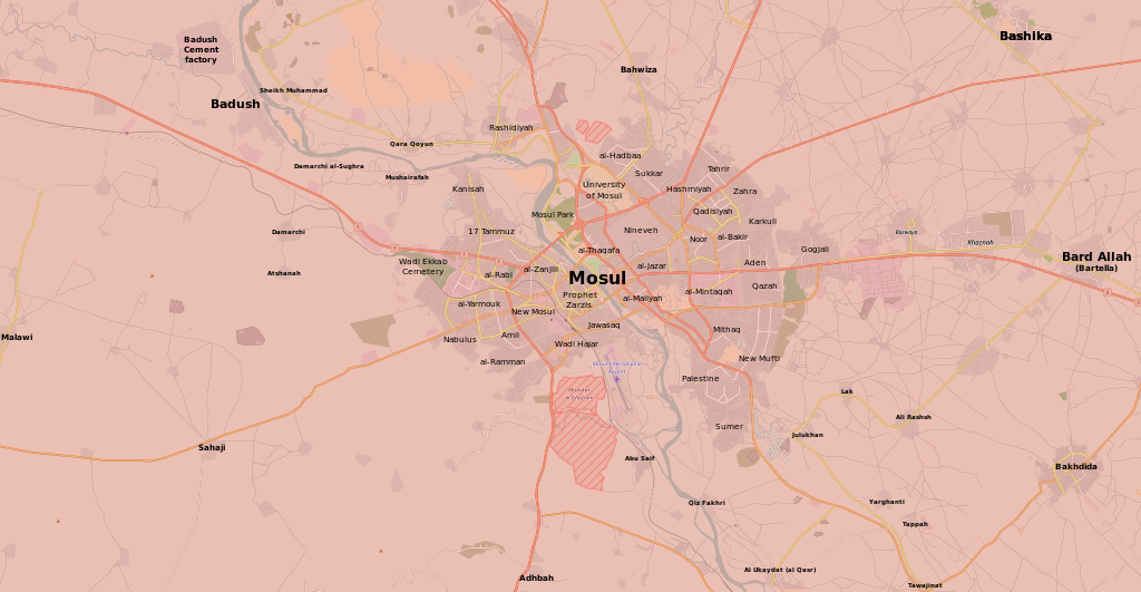
English: Map of the current situation in Mosul, during the Battle of Mosul (2016–17). After updating this map, please also update the date(s) at w:Module:Iraq Syria map date, used to denote the date in articles.
Controlled by the Iraqi Security Forces
Controlled by the Peshmerga (Kurdish Forces)
Controlled by the Islamic State of Iraq and the Levant
The disputed frontline between the forces |
| 날짜 | |
| 출처 | 자작 |
| 저자 | Kami888 |
라이선스
| This work contains information from OpenStreetMap, which is made available under the Open Database License (ODbL).
The ODbL does not require any particular license for maps produced from ODbL data. Prior to 1 August 2020, map tiles produced by the OpenStreetMap Foundation were licensed under the CC-BY-SA-2.0 license. Maps produced by other people may be subject to other licences. |
나는 아래 작품의 저작권자로서, 이 저작물을 다음과 같은 라이선스로 배포합니다:
이 파일은 크리에이티브 커먼즈 저작자표시-동일조건변경허락 4.0 국제 라이선스로 배포됩니다.
- 이용자는 다음의 권리를 갖습니다:
- 공유 및 이용 – 저작물의 복제, 배포, 전시, 공연 및 공중송신
- 재창작 – 저작물의 개작, 수정, 2차적저작물 창작
- 다음과 같은 조건을 따라야 합니다:
- 저작자표시 – 적절한 저작자 표시를 제공하고, 라이센스에 대한 링크를 제공하고, 변경사항이 있는지를 표시해야 합니다. 당신은 합리적인 방식으로 표시할 수 있지만, 어떤 방식으로든 사용권 허가자가 당신 또는 당신의 사용을 지지하는 방식으로 표시할 수 없습니다.
- 동일조건변경허락 – 만약 당신이 이 저작물을 리믹스 또는 변형하거나 이 저작물을 기반으로 제작하는 경우, 당신은 당신의 기여물을 원저작물과 동일하거나 호환 가능한 라이선스에 따라 배포하여야 합니다.
파일 역사
날짜/시간 링크를 클릭하면 해당 시간의 파일을 볼 수 있습니다.
.svg&dir=prev)
.svg&offset=20170613030201)
.svg&offset=&limit=20)
.svg&offset=&limit=50)
.svg&offset=&limit=100)
.svg&offset=&limit=250)
.svg&offset=&limit=500)
| 날짜/시간 | 섬네일 | 크기 | 사용자 | 설명 | |
|---|---|---|---|---|---|
| 현재 | 2017년 12월 20일 (수) 20:46 | | 2,555 × 1,325 (6.69 MB) | Kami888 | Peshmerga doesn't control Bashika and neighborhood since 17 October. |
| 2017년 7월 11일 (화) 18:14 |  | 2,555 × 1,325 (6.71 MB) | Kami888 | Looks like the battle is over. http://www.centcom.mil/MEDIA/PRESS-RELEASES/Press-Release-View/Article/1242031/iraqi-security-forces-liberate-mosul/ Also cropped the image. | |
| 2017년 7월 7일 (금) 13:23 |  | 2,555 × 1,325 (7.06 MB) | Kami888 | new ISF claim: https://pbs.twimg.com/media/DEEKWV3XUAEG31H.jpg:large , old city almost cleared | |
| 2017년 7월 2일 (일) 07:48 |  | 2,555 × 1,325 (7.01 MB) | Kami888 | iraqi media claim https://pbs.twimg.com/media/DDqaKPHXoAEogn7?format=jpg | |
| 2017년 6월 25일 (일) 12:17 |  | 2,555 × 1,325 (7 MB) | Kami888 | https://pbs.twimg.com/media/DDGUQXfXkAEQFsM?format=jpg | |
| 2017년 6월 14일 (수) 09:55 |  | 2,555 × 1,325 (7 MB) | Kami888 | That's great, but could you not update unless you know what you're doing? I end up getting complaints lol. You need an svg editor and some basic knowledge of vector graphics to edit. | |
| 2017년 6월 14일 (수) 02:45 |  | 1,920 × 996 (1.29 MB) | Lightanddark1775 | Thank you. Sorry to have to revert, but Malawi has also been liberated by ISF. How do I correctly edit this map? | |
| 2017년 6월 13일 (화) 18:55 |  | 2,555 × 1,325 (7 MB) | Kami888 | fixed it for you | |
| 2017년 6월 13일 (화) 12:04 |  | 1,920 × 996 (1.29 MB) | Lightanddark1775 | Malawi and al-Zanjili have been completely liberated by ISF. The old city has now been invaded by ISF in the final push to remove ISIS from Mosul. | |
| 2017년 6월 13일 (화) 12:02 |  | 1,920 × 996 (1.29 MB) | Lightanddark1775 | Malawi and al-Zanjili have been completely liberated by ISF. The old city has now been invaded by ISF in the final push to remove ISIS from Mosul. |
이 파일을 사용하는 문서
다음 문서 1개가 이 파일을 사용하고 있습니다:
이 파일을 사용하고 있는 모든 위키의 문서 목록
다음 위키에서 이 파일을 사용하고 있습니다:
- ar.wikipedia.org에서 이 파일을 사용하고 있는 문서 목록
- azb.wikipedia.org에서 이 파일을 사용하고 있는 문서 목록
- br.wikipedia.org에서 이 파일을 사용하고 있는 문서 목록
- ca.wikipedia.org에서 이 파일을 사용하고 있는 문서 목록
- ckb.wikipedia.org에서 이 파일을 사용하고 있는 문서 목록
- cs.wikipedia.org에서 이 파일을 사용하고 있는 문서 목록
- de.wikipedia.org에서 이 파일을 사용하고 있는 문서 목록
- en.wikipedia.org에서 이 파일을 사용하고 있는 문서 목록
- es.wikinews.org에서 이 파일을 사용하고 있는 문서 목록
- fa.wikipedia.org에서 이 파일을 사용하고 있는 문서 목록
- fi.wikipedia.org에서 이 파일을 사용하고 있는 문서 목록
- hu.wikipedia.org에서 이 파일을 사용하고 있는 문서 목록
- id.wikipedia.org에서 이 파일을 사용하고 있는 문서 목록
- is.wikipedia.org에서 이 파일을 사용하고 있는 문서 목록
- it.wikipedia.org에서 이 파일을 사용하고 있는 문서 목록
- mk.wikipedia.org에서 이 파일을 사용하고 있는 문서 목록
- ms.wikipedia.org에서 이 파일을 사용하고 있는 문서 목록
- nl.wikipedia.org에서 이 파일을 사용하고 있는 문서 목록
- pnb.wikipedia.org에서 이 파일을 사용하고 있는 문서 목록
- ro.wikipedia.org에서 이 파일을 사용하고 있는 문서 목록
- ru.wikipedia.org에서 이 파일을 사용하고 있는 문서 목록
- uk.wikipedia.org에서 이 파일을 사용하고 있는 문서 목록
- ur.wikipedia.org에서 이 파일을 사용하고 있는 문서 목록
- vi.wikipedia.org에서 이 파일을 사용하고 있는 문서 목록
- www.wikidata.org에서 이 파일을 사용하고 있는 문서 목록
- zh.wikipedia.org에서 이 파일을 사용하고 있는 문서 목록
.svg)