
파일:AlapahaRiver2002.jpg

미리 보기 크기: 800 × 600 픽셀 다른 해상도: 320 × 240 픽셀 | 640 × 480 픽셀 | 1,024 × 768 픽셀 | 1,280 × 960 픽셀 | 2,010 × 1,507 픽셀
원본 파일 (2,010 × 1,507 픽셀, 파일 크기: 641 KB, MIME 종류: image/jpeg)
파일 설명
| 설명 |
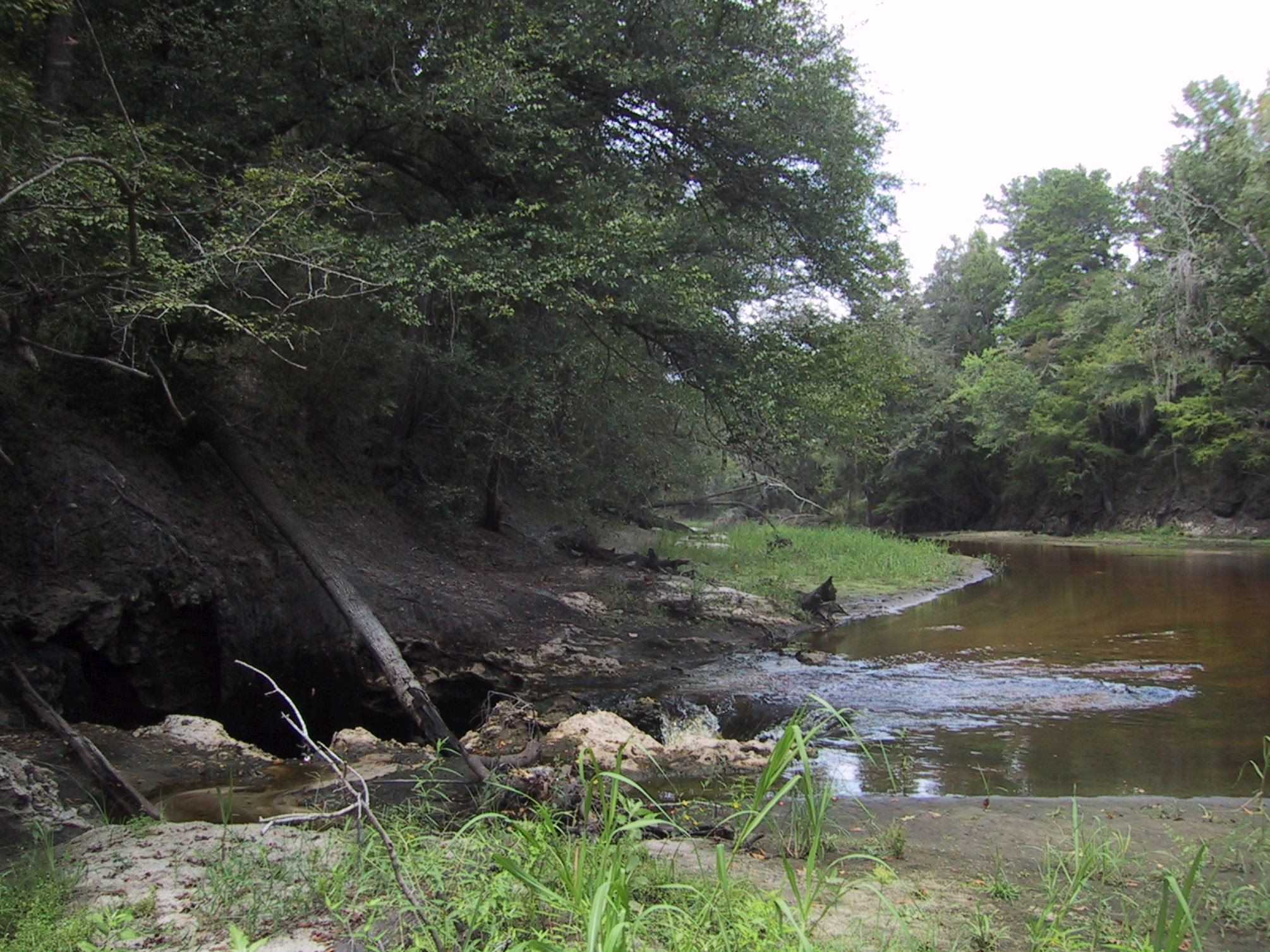
English: Surface water-Groundwater (SW-GW) interaction , August 2002. Entire flow of Alapaha River near Jennings going into sinkhole to Floridan Aquifer. Sinkholes are one of a variety of properties of Karst topographies and carstic underground water systems that develope world wide in water soluble (chemically soluble) rocks (in Florida: carbonate rocks). |
| 날짜 | |
| 출처 | USGS Surface Water Photo Gallery[1], item 14 01. |
| 저자 | Stewart Tomlinson, Florida |
라이선스
|
|
기존 올리기 기록
The original description page was here. All following user names refer to en.wikipedia.
- 2008-09-01 03:17 Suntag 2010×1507× (656603 bytes)
파일 역사
날짜/시간 링크를 클릭하면 해당 시간의 파일을 볼 수 있습니다.
| 날짜/시간 | 섬네일 | 크기 | 사용자 | 설명 | |
|---|---|---|---|---|---|
| 현재 | 2012년 5월 20일 (일) 05:52 | | 2,010 × 1,507 (641 KB) | MathewTownsend | {{Information |Description={{en|en:Surface water-en:Groundwater (SW-GW) interaction , August 2002. Entire flow of en:Alapaha River near en:Jennings, Florida going into en:sinkhole to en:Floridan Aquifer.<br> Sinkhole... |
이 파일을 사용하는 문서
다음 문서 2개가 이 파일을 사용하고 있습니다:
이 파일을 사용하고 있는 모든 위키의 문서 목록
다음 위키에서 이 파일을 사용하고 있습니다:
- ar.wikipedia.org에서 이 파일을 사용하고 있는 문서 목록
- az.wikipedia.org에서 이 파일을 사용하고 있는 문서 목록
- ckb.wikipedia.org에서 이 파일을 사용하고 있는 문서 목록
- en.wikipedia.org에서 이 파일을 사용하고 있는 문서 목록
- fa.wikipedia.org에서 이 파일을 사용하고 있는 문서 목록
- hi.wikipedia.org에서 이 파일을 사용하고 있는 문서 목록
- id.wikipedia.org에서 이 파일을 사용하고 있는 문서 목록
- ig.wikipedia.org에서 이 파일을 사용하고 있는 문서 목록
- ml.wikipedia.org에서 이 파일을 사용하고 있는 문서 목록
- mr.wikipedia.org에서 이 파일을 사용하고 있는 문서 목록
- pa.wikipedia.org에서 이 파일을 사용하고 있는 문서 목록
- simple.wikipedia.org에서 이 파일을 사용하고 있는 문서 목록
- su.wikipedia.org에서 이 파일을 사용하고 있는 문서 목록
- ta.wikipedia.org에서 이 파일을 사용하고 있는 문서 목록
- tr.wikipedia.org에서 이 파일을 사용하고 있는 문서 목록
- vi.wikipedia.org에서 이 파일을 사용하고 있는 문서 목록
- zh-yue.wikipedia.org에서 이 파일을 사용하고 있는 문서 목록