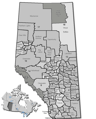
모듈:Location map/data/Alberta municipal districts/설명문서
| 이 문서는 모듈:Location map/data/Alberta municipal districts에 대한 설명입니다. 여기에는 틀 사용법, 분류 등 원래의 모듈 문서에는 포함되지 않는 내용을 담고 있습니다. |
| 이름 | 앨버타주 | ||
|---|---|---|---|
| x | (47.8062 + 6.31607*($2+115) + 0.033133*($1-55) -0.163349*($1-55)*($2+115) + 0.0101163*($2+115)*($2+115) -0.00888419*($1-55)*($1-55)) | ||
| y | (45.9081 -0.0512779*($2+115) -8.84793*($1-55) + 0.0102564*($1-55)*($2+115) -0.0167721*($2+115)*($2+115) + 0.0226062*($1-55)*($1-55)) | ||
| 그림 | Alberta municipal districts.png
| ||

| |||
모듈:Location map/data/Alberta municipal districts는 앨버타주의 등장방형도법 지도에 오버레이 마커 및 꼬리표를 표시하기 위한 위치 지도의 루아 모듈입니다. 마커는 기존의 지도나 유사한 지도 이미지에서 경도나 위도의 좌표에 따라 표시됩니다.
사용법
이러한 정의는 매개변수 "Alberta municipal districts"(을)를 사용하여 호출될 때 다음 틀에서 사용된다:
{{위치 지도|Alberta municipal districts |...}}{{위치 지도 여럿|Alberta municipal districts |...}}{{위치 지도+|Alberta municipal districts |...}}{{위치 지도~|Alberta municipal districts |...}}
지도 정의
name = 앨버타주- 기본 지도 설명에 사용된 이름
image = Alberta municipal districts.png- "그림:" 또는 "파일:" 이 없는 기본 지도 그림
x = (47.8062 + 6.31607*($2+115) + 0.033133*($1-55) -0.163349*($1-55)*($2+115) + 0.0101163*($2+115)*($2+115) -0.00888419*($1-55)*($1-55))- 경도를 기초로 하여 지도 상의 위치를 계산하는 식이며, 최서단은 0, 최동단은 100이 됩니다.
y = (45.9081 -0.0512779*($2+115) -8.84793*($1-55) + 0.0102564*($1-55)*($2+115) -0.0167721*($2+115)*($2+115) + 0.0226062*($1-55)*($1-55))- 위도를 기초로 하여 지도 상의 위치를 계산하는 식이며, 최북단은 0, 최남단은 100이 됩니다.
위치 지도 틀을 사용한 예시
Test of pins in the corners and corner of Wood Buffalo National Park
같이 보기
위치 지도 틀
- 틀:위치 지도 - 위도와 경도를 사용해서 하나의 마크와 라벨을 표시합니다.
- 틀:위치 지도 여럿 - 9개까지의 마크와 라벨을 표시합니다.
- 틀:위치 지도+ - 마크와 라벨을 개수 제한 없이 표시할 수 있습니다.
새로운 지도 모듈 만들기
- Template:Location map/Creating a new map definition (영어판) - 모듈 작성 설명 문서

