마누아 제도


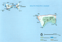
마누아제도(Manuʻa Islands[1][2][3], Manuʻa tele)는 사모아 제도에 위치하며 3개의 섬으로 구성되어 있다: 타우섬, 오푸섬, 올로세가섬.[4][5][6] 뒤의 두 섬은 현재 해협을 경유하는 다리로 연결되어 있다. 이 섬들은 투투일라섬으로부터 동쪽으로 110킬로미터 지점에 위치하며 미국의 해외 영토인 아메리칸사모아의 일부이다. 이들을 모두 합친 면적은 56제곱 킬로미터이며 총 인구 수는 1,400명이다. 타우섬은 이 섬들 가운데 가장 큰 섬으로, 면적은 44제곱킬로미터에 달하며 마누아제도에서 가장 높은 곳은 931미터이다.
각주[편집]
- ↑ https://www.britannica.com/place/Manua-Islands Britannica.com. Manua Islands. Retrieved July 4, 2020.
- ↑ https://www.nps.gov/npsa/learn/historyculture/nameeson-land.htm U.S. National Park Service. National Park of American Samoa. Names Upon the Land. Retrieved July 4, 2020.
- ↑ https://www.lonelyplanet.com/american-samoa/manua-islands Lonely Planet. Manu'a Islands. Retrieved July 4, 2020.
- ↑ Hills, J.W. (2010). O upu muamua i le Tala i le Lalolagi mo e ua faatoa aʻoaʻoina u lea mataupu: Elementary Geography. Nabu Press. Page 62. ISBN 9781147952896.
- ↑ Gupta, Alok K. (1998). Igneous Rocks. Allied Publishers. Page 382. ISBN 9788170237846.
- ↑ Shaffer, Robert J. (2000). American Samoa: 100 Years Under the United States Flag. Island Heritage. Page 210. ISBN 9780896103399.
