
파일:WVStatehoodVote.png
최대 해상도입니다.
WVStatehoodVote.png (672 × 600 픽셀, 파일 크기: 115 KB, MIME 종류: image/png)
파일 설명
| 설명 |
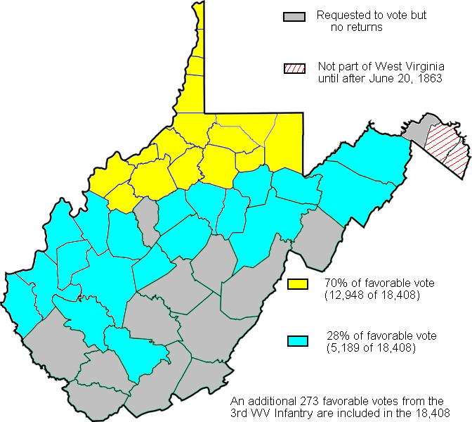
English: Map created based on the voting results of statehood referendum on Oct. 24, 1861 in West Virginia as compiled by Richard O. Curry in "A House Divided", pgs. 141-152. |
| 날짜 | |
| 출처 | My creation from data in R. Curry's "A House Divided" pgs. 141-152 |
| 저자 | Dubyavee |
라이선스
| 나는 이 작품의 저작권자로서, 이 작품을 퍼블릭 도메인으로 모두에게 공개합니다. 이 공개 선언은 전 세계적으로 유효합니다. 만약 저작권의 포기가 법률적으로 가능하지 않은 경우, 나는 이 작품을 법적으로 허용되는 한도 내에서 누구나 자유롭게 어떤 목적으로도 제한없이 사용할 수 있도록 허용합니다. |
파일 역사
날짜/시간 링크를 클릭하면 해당 시간의 파일을 볼 수 있습니다.
| 날짜/시간 | 섬네일 | 크기 | 사용자 | 설명 | |
|---|---|---|---|---|---|
| 현재 | 2011년 2월 5일 (토) 02:19 | | 672 × 600 (115 KB) | Maproom | Repaired broken characters "a", "8". Reduced fringes from floodfill. |
| 2009년 9월 27일 (일) 10:11 |  | 672 × 600 (122 KB) | Dubyavee | Corrected some errors in numbers, noted small soldier vote | |
| 2009년 7월 27일 (월) 08:29 |  | 672 × 600 (125 KB) | Dubyavee | changed Raleigh county from 'gray' to 'blue' to correct error in original. | |
| 2009년 7월 27일 (월) 08:11 |  | 672 × 600 (125 KB) | Dubyavee | {{Information |Description={{en|1=Map created based on the voting results of statehood referendum on Oct. 24, 1861 in West Virginia as compiled by Richard O. Curry in "A House Divided", pgs. 141-152.}} |Source=My creation from data in R. Curry's "A House |
이 파일을 사용하는 문서
다음 문서 1개가 이 파일을 사용하고 있습니다:
이 파일을 사용하고 있는 모든 위키의 문서 목록
다음 위키에서 이 파일을 사용하고 있습니다:
- fr.wikipedia.org에서 이 파일을 사용하고 있는 문서 목록
- fy.wikipedia.org에서 이 파일을 사용하고 있는 문서 목록
- it.wikipedia.org에서 이 파일을 사용하고 있는 문서 목록
- ja.wikipedia.org에서 이 파일을 사용하고 있는 문서 목록