
파일:Kashmir map.jpg

원본 파일 (974 × 1,120 픽셀, 파일 크기: 807 KB, MIME 종류: image/jpeg)
파일 설명
| 설명 |
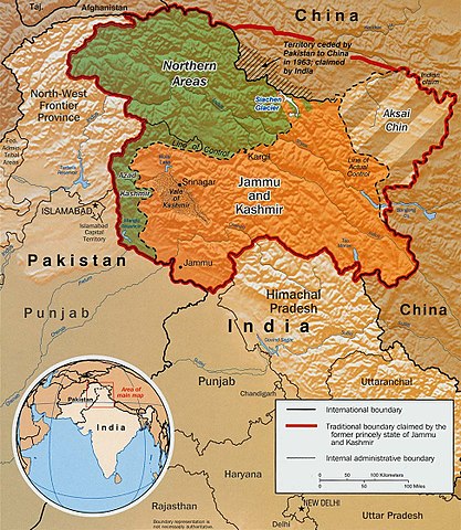
Original text from CIA World Factbook: "The Disputed Territory : Shown in green is Kashmiri region under Pakistani control. The dark-brown region represents Indian-controlled Jammu and Kashmir while the Aksai Chin is under Chinese occupation." Library of Congress, Geography and Map Division, Washington, D.C. 20540-4650 USA. Info from its archive page [1] for this map: Kashmir region. United States. Central Intelligence Agency. CREATED/PUBLISHED [Washington : Central Intelligence Agency, 2003] NOTES "763537AI (R00744) 5-03." Relief shown by shading. Shows boundaries and disputed areas. Includes location map. Scale [ca. 1:510,000]. SUBJECTS
MEDIUM 1 map : col. ; 20 x 17 cm. CALL NUMBER G7653.J3 2003 .U51 REPOSITORY Library of Congress Geography and Map Division Washington, D.C. 20540-4650 USA DIGITAL ID g7653j ct001059 http://hdl.loc.gov/loc.gmd/g7653j.ct001059 |
|||
| 날짜 | ||||
| 출처 |
Map is archived here: http://hdl.loc.gov/loc.gmd/g7653j.ct001059 and http://www.lib.utexas.edu/maps/middle_east_and_asia/kashmir_disputed_2003.jpg |
|||
| 저자 | Central Intelligence Agency | |||
| 저작권 (이 파일을 인용하기) |
|
|||
| 다른 버전 | العربيَّة |

파일 역사
날짜/시간 링크를 클릭하면 해당 시간의 파일을 볼 수 있습니다.
| 날짜/시간 | 섬네일 | 크기 | 사용자 | 설명 | |
|---|---|---|---|---|---|
| 현재 | 2016년 3월 6일 (일) 17:34 | | 974 × 1,120 (807 KB) | Denniss | Reverted to version as of 23:18, 6 June 2010 (UTC) |
| 2010년 6월 7일 (월) 08:18 |  | 974 × 1,120 (807 KB) | Ras67 | slightly rotated and cropped | |
| 2007년 9월 11일 (화) 04:55 |  | 1,029 × 1,209 (310 KB) | Timeshifter | Larger version of the same CIA map. {{PD-USGov-CIA-WF}} | |
| 2005년 6월 13일 (월) 17:08 |  | 470 × 565 (72 KB) | Emuzesto | From en:. Original text: The Disputed Territory : Shown in green is Kashmiri region under Pakistani control. The dark-brown region represents Indian-controlled Jammu and Kashmir while the Aksai Chin is under Chinese occupati |
이 파일을 사용하는 문서
다음 문서 2개가 이 파일을 사용하고 있습니다:
이 파일을 사용하고 있는 모든 위키의 문서 목록
다음 위키에서 이 파일을 사용하고 있습니다:
- ar.wikipedia.org에서 이 파일을 사용하고 있는 문서 목록
- az.wikipedia.org에서 이 파일을 사용하고 있는 문서 목록
- bh.wikipedia.org에서 이 파일을 사용하고 있는 문서 목록
- bn.wikipedia.org에서 이 파일을 사용하고 있는 문서 목록
- bpy.wikipedia.org에서 이 파일을 사용하고 있는 문서 목록
- ca.wikipedia.org에서 이 파일을 사용하고 있는 문서 목록
- cs.wikipedia.org에서 이 파일을 사용하고 있는 문서 목록
- de.wikipedia.org에서 이 파일을 사용하고 있는 문서 목록
- el.wikipedia.org에서 이 파일을 사용하고 있는 문서 목록
- en.wikipedia.org에서 이 파일을 사용하고 있는 문서 목록
- Pakistan
- Talk:List of ongoing armed conflicts
- User talk:Vkvora2001
- Operation Meghdoot
- Saltoro Mountains
- Ghent Kangri
- Talk:India/Archive 18
- Bilafond La
- Sia La
- Portal:Maps/Maps/Political
- User:Mattisse//Maps
- Conrad O'Brien-ffrench
- Portal:Maps/Maps/Political/13
- Gyong La
- Siachen Base Camp (India)
- Actual Ground Position Line
- Talk:Azad Kashmir/Archives/2011–2012
- Chumik Glacier
- User talk:Sofishahidanzwalla Anantnag
- Saltoro Valley
- 1992 India–Pakistan floods
- User:Falcaorib/India and Pakistan
- fa.wikipedia.org에서 이 파일을 사용하고 있는 문서 목록
- fr.wikipedia.org에서 이 파일을 사용하고 있는 문서 목록
- gl.wikipedia.org에서 이 파일을 사용하고 있는 문서 목록
- hi.wikipedia.org에서 이 파일을 사용하고 있는 문서 목록
이 파일의 더 많은 사용 내역을 봅니다.