니더바이에른현

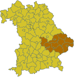
니더바이에른 현(독일어: Niederbayern)은 독일 바이에른 주 동부에 위치한 현(Regierungsbezirk)이다. 면적 10,329.87 km², 인구 1,189,194 (2011)[1], 인구 밀도 120/km². 현청 소재지는 란츠후트.
바이에른 주 중동부에 위치한다. 도나우 강 유역 지역이다. 오랫동안 바이에른의 일부로 이어져 왔으며 현재의 현은 1837년 바이에른 왕국 당시 왕국의 한 주인 니더바이에른으로 형성된 것에서 유래한다. 9개 군(Landkreise), 3개 시(Kreisfreie Städte)로 구성되어 있다.
하위 행정 구역
군(Landkreise)
- 데겐도르프 군(Landkreis Deggendorf)
- 딘골핑란다우 군(Landkreis Dingolfing-Landau)
- 프라이웅그라페나우 군(Landkreis Freyung-Grafenau)
- 켈하임 군(Landkreis Kelheim)
- 란츠후트 군(Landkreis Landshut)
- 파사우 군(Landkreis Passau)
- 레겐 군(Landkreis Regen)
- 로탈인 군(Landkreis Rottal-Inn)
- 슈트라우빙보겐 군(Landkreis Straubing-Bogen)
시(Kreisfreie Städte)
주석
- ↑ (독일어) "Fortschreibung des Bevölkerungsstandes" Bayerisches Landesamt für Statistik und Datenverarbeitung.
바깥 고리
| 이 글은 독일에 관한 토막글입니다. 여러분의 지식으로 알차게 문서를 완성해 갑시다. |
