
파일:W-RSimpleMap.gif

미리 보기 크기: 432 × 599 픽셀 다른 해상도: 173 × 240 픽셀 | 346 × 480 픽셀 | 554 × 768 픽셀 | 738 × 1,024 픽셀 | 1,960 × 2,718 픽셀
원본 파일 (1,960 × 2,718 픽셀, 파일 크기: 2.08 MB, MIME 종류: image/gif)
파일 설명
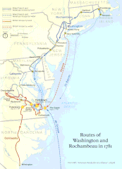
| 설명 | Official National Park Service map of the Washington-Rochambeau Revolutionary Route |
| 날짜 | |
| 출처 | http://www.nps.gov/boso/w-r |
| 저자 | National Park Service |
| 저작권 (이 파일을 인용하기) |
"The maps at this site are in the public domain. You may use National Park Service maps provided that you agree to assume complete legal responsibility for problems resulting from their use. Although National Park Service maps are easy to modify, understand that modifications can adversely alter the meaning and accuracy of the original data. Law prohibits you from using the National Park Service seal or claiming National Park Service endorsement with downloaded maps." [1] |
라이선스
| This image or media file contains material based on a work of a National Park Service employee, created as part of that person's official duties. As a work of the U.S. federal government, such work is in the public domain in the United States. See the NPS website and NPS copyright policy for more information. |

|
이 그림 파일은 벡터 SVG 형식으로 다시 만들어야 합니다. SVG의 장점에 대해서는 여기(영어)를 참고해 주십시오. 만약 이 그림의 SVG 버전이 이미 존재한다면 이 틀을 {{vector version available|새 파일 이름.svg}}으로 대체해 주십시오.
|
파일 역사
날짜/시간 링크를 클릭하면 해당 시간의 파일을 볼 수 있습니다.
| 날짜/시간 | 섬네일 | 크기 | 사용자 | 설명 | |
|---|---|---|---|---|---|
| 현재 | 2008년 4월 14일 (월) 04:39 | | 1,960 × 2,718 (2.08 MB) | Evrik | == Summary == {{Information |Description = Official National Park Service map of the Washington-Rochambeau Revolutionary Route |Source = [http://www.nps.gov/boso/w-r] |Date = |
이 파일을 사용하는 문서
다음 문서 1개가 이 파일을 사용하고 있습니다:
이 파일을 사용하고 있는 모든 위키의 문서 목록
다음 위키에서 이 파일을 사용하고 있습니다:
- ca.wikipedia.org에서 이 파일을 사용하고 있는 문서 목록
- el.wikipedia.org에서 이 파일을 사용하고 있는 문서 목록
- en.wikipedia.org에서 이 파일을 사용하고 있는 문서 목록
- Newport, Rhode Island
- Siege of Yorktown
- Jean-Baptiste Donatien de Vimeur, comte de Rochambeau
- James Manning (minister)
- France in the American Revolutionary War
- Yorktown campaign
- Washington–Rochambeau Revolutionary Route
- March Route of Rochambeau's Army: Scotland Road
- Fourth Camp of Rochambeau's Army
- March Route of Rochambeau's Army: Manship Road-Barstow Road
- March Route of Rochambeau's Army: Palmer Road
- March Route of Rochambeau's Army: Plainfield Pike
- March Route of Rochambeau's Army: Bailey Road
- March Route of Rochambeau's Army: Reservoir Road
- March Route of Rochambeau's Army: Ridgebury Road
- List of historic sites preserved along Rochambeau's route
- User:Ile da france b17/sandbox
- en.wikivoyage.org에서 이 파일을 사용하고 있는 문서 목록
- es.wikipedia.org에서 이 파일을 사용하고 있는 문서 목록
- fa.wikipedia.org에서 이 파일을 사용하고 있는 문서 목록
- fr.wikipedia.org에서 이 파일을 사용하고 있는 문서 목록
- it.wikipedia.org에서 이 파일을 사용하고 있는 문서 목록
- ja.wikipedia.org에서 이 파일을 사용하고 있는 문서 목록
- pt.wikipedia.org에서 이 파일을 사용하고 있는 문서 목록
- ru.wikipedia.org에서 이 파일을 사용하고 있는 문서 목록
- www.wikidata.org에서 이 파일을 사용하고 있는 문서 목록
- zh.wikipedia.org에서 이 파일을 사용하고 있는 문서 목록