
파일:Saint Helena Island.jpg

원본 파일 (1,440 × 1,080 픽셀, 파일 크기: 634 KB, MIME 종류: image/jpeg)
파일 설명

|
이 사진은 가치있는 사진 조건을 만족하며, 다음 분야에서 공용에서 가장 가치있는 사진으로 여겨집니다: Saint Helena Island. 이 사진에 관한 토론을 여기에서 보실 수 있습니다. |
| 설명 |
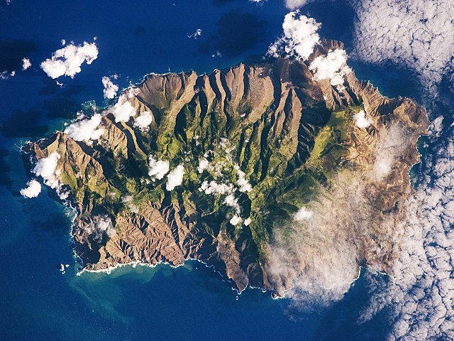
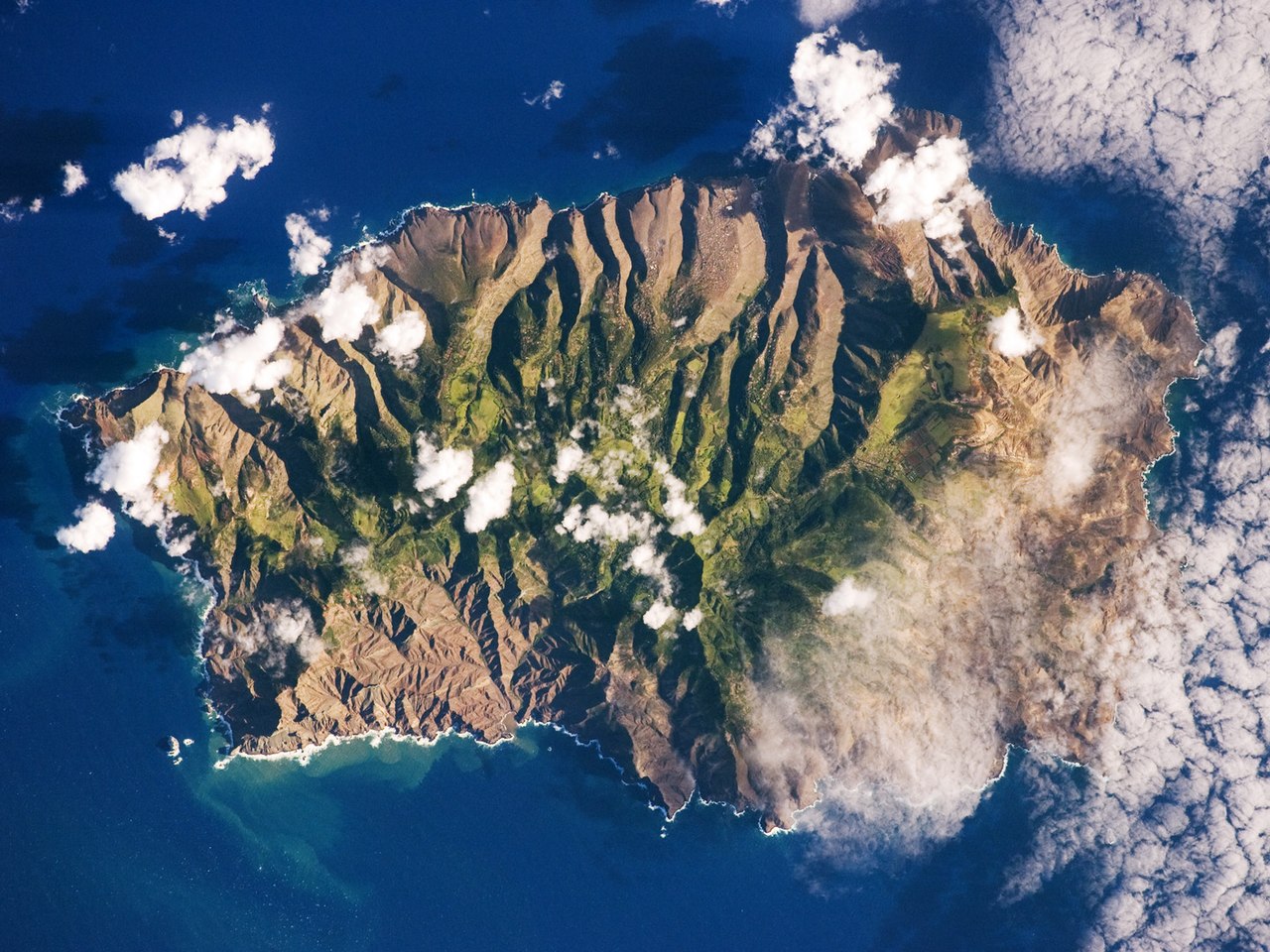
English: This astronaut photograph shows the island’s sharp peaks and deep ravines; the rugged topography results from erosion of the volcanic rocks that make up the island. The change in elevation from the coast to the interior creates a climate gradient. The higher, wetter centre is covered with green vegetation, whereas the lower coastal areas are drier and hotter, with little vegetation cover.
Français : Photo de l'île de Sainte Hélène prise par un astronaute de la NASA. On peut voir les pics élevés de l'île et ses ravines profondes. Cette topographie accidentée résulte de l'action de l'érosion sur les roches volcaniques dont l'île est constituée. Le changement d'élévation entre la périphérie et le centre de l'île créé un gradient climatique: le sommet est plus frais et humide, il est couvert de végétation. Les côtes, plus chaudes et sèches, laissent apparaitre la roche nue.
|
||||||||||||||||||||||||||||||||||||||||||||||||||||||
| 날짜 | |||||||||||||||||||||||||||||||||||||||||||||||||||||||
| 출처 | NASA Earth Observatory | ||||||||||||||||||||||||||||||||||||||||||||||||||||||
| 저자 | This image was taken by the NASA Expedition 19 crew. | ||||||||||||||||||||||||||||||||||||||||||||||||||||||
| 다른 버전 |
|
||||||||||||||||||||||||||||||||||||||||||||||||||||||

| 카메라 위치 | | 이 지역의 다른 사진을 보기: OpenStreetMap |
|---|
This photograph was acquired with a Nikon 2DXs digital camera fitted with a 400 mm lens, and is provided by the ISS Crew Earth Observations experiment and Image Science & Analysis Laboratory, Johnson Space Centre.
Deutsch: Dieses Bild wurde als Bild der Woche auf der tschechischen Wikipedia für die 5 Woche ausgewählt, 2016. English: This image was selected as a picture of the week on the Czech Wikipedia for 5th week, 2016. Français : Cette image est sélectionnée en tant qu’image de la semaine sur la Wikipédia Tchèque pour la 5e semaine de 2016. Italiano: Questa immagine è stata selezionata come Immagine della settimana su Wikipedia in ceco per la V settimana del 2016. Македонски: Сликава е избрана за слика на неделата на чешката Википедија за V недела од 2016 година. Русский: Эта иллюстрация была выбрана изображением недели в чешском разделе «Википедии» для недели номер 5 2016 года. Українська: Ця ілюстрація була вибрана зображенням тижня в чеському розділі «Вікіпедії» для тижня номер 5, 2016 року. |
라이선스
| 이 파일은 NASA에서 제작하였으므로 퍼블릭 도메인입니다. NASA의 저작권 정책에 따르면 NASA의 자료는 명시하지 않는 이상 저작권의 보호를 받지 않습니다. (Template:PD-USGov, 또는 NASA 저작권 정책 문서, JPL 그림 사용 정책을 참고하세요.) | ||
 |
주의사항:
|
| 주석 | 이 이미지에는 주석이 있습니다: 공용에서 주석을 보기 |
파일 역사
날짜/시간 링크를 클릭하면 해당 시간의 파일을 볼 수 있습니다.
| 날짜/시간 | 섬네일 | 크기 | 사용자 | 설명 | |
|---|---|---|---|---|---|
| 현재 | 2015년 3월 23일 (월) 20:28 | | 1,440 × 1,080 (634 KB) | Julian Herzog | Reverted to version as of 18:00, 19 March 2015, rotation was done then. |
| 2015년 3월 20일 (금) 17:00 |  | 1,440 × 1,080 (634 KB) | SteinsplitterBot | Bot: Image rotated by 180° | |
| 2015년 3월 20일 (금) 03:00 |  | 1,440 × 1,080 (634 KB) | SteinsplitterBot | Bot: Image rotated by 180° | |
| 2009년 6월 15일 (월) 18:40 |  | 1,440 × 1,080 (622 KB) | Originalwana | {{Information |Description={{en|1=This astronaut photograph shows the island’s sharp peaks and deep ravines; the rugged topography results from erosion of the volcanic rocks that make up the island. The change in elevation from the coast to the interior |
이 파일을 사용하는 문서
다음 문서 1개가 이 파일을 사용하고 있습니다:
이 파일을 사용하고 있는 모든 위키의 문서 목록
다음 위키에서 이 파일을 사용하고 있습니다:
- als.wikipedia.org에서 이 파일을 사용하고 있는 문서 목록
- ar.wikipedia.org에서 이 파일을 사용하고 있는 문서 목록
- arz.wikipedia.org에서 이 파일을 사용하고 있는 문서 목록
- ast.wikipedia.org에서 이 파일을 사용하고 있는 문서 목록
- az.wikipedia.org에서 이 파일을 사용하고 있는 문서 목록
- be.wikipedia.org에서 이 파일을 사용하고 있는 문서 목록
- bg.wikipedia.org에서 이 파일을 사용하고 있는 문서 목록
- br.wikipedia.org에서 이 파일을 사용하고 있는 문서 목록
- bs.wikipedia.org에서 이 파일을 사용하고 있는 문서 목록
- ca.wikipedia.org에서 이 파일을 사용하고 있는 문서 목록
- ceb.wikipedia.org에서 이 파일을 사용하고 있는 문서 목록
- ce.wikipedia.org에서 이 파일을 사용하고 있는 문서 목록
- co.wikipedia.org에서 이 파일을 사용하고 있는 문서 목록
- cs.wikipedia.org에서 이 파일을 사용하고 있는 문서 목록
- da.wikipedia.org에서 이 파일을 사용하고 있는 문서 목록
- de.wikipedia.org에서 이 파일을 사용하고 있는 문서 목록
- en.wikipedia.org에서 이 파일을 사용하고 있는 문서 목록
- en.wikiversity.org에서 이 파일을 사용하고 있는 문서 목록
- eo.wikipedia.org에서 이 파일을 사용하고 있는 문서 목록
- es.wikipedia.org에서 이 파일을 사용하고 있는 문서 목록
- es.wiktionary.org에서 이 파일을 사용하고 있는 문서 목록
- fi.wiktionary.org에서 이 파일을 사용하고 있는 문서 목록
- frp.wikipedia.org에서 이 파일을 사용하고 있는 문서 목록
- fr.wikipedia.org에서 이 파일을 사용하고 있는 문서 목록
- fr.wikivoyage.org에서 이 파일을 사용하고 있는 문서 목록
- ga.wikipedia.org에서 이 파일을 사용하고 있는 문서 목록
- gl.wikipedia.org에서 이 파일을 사용하고 있는 문서 목록
- he.wikipedia.org에서 이 파일을 사용하고 있는 문서 목록
- hy.wikipedia.org에서 이 파일을 사용하고 있는 문서 목록
- ig.wikipedia.org에서 이 파일을 사용하고 있는 문서 목록
- it.wikipedia.org에서 이 파일을 사용하고 있는 문서 목록
이 파일의 더 많은 사용 내역을 봅니다.