
파일:Roman provinces of Illyricum, Macedonia, Dacia, Moesia, Pannonia and Thracia.jpg

미리 보기 크기: 740 × 600 픽셀 다른 해상도: 296 × 240 픽셀 | 592 × 480 픽셀 | 947 × 768 픽셀 | 1,263 × 1,024 픽셀 | 2,526 × 2,048 픽셀 | 2,817 × 2,284 픽셀
원본 파일 (2,817 × 2,284 픽셀, 파일 크기: 1.41 MB, MIME 종류: image/jpeg)
| 설명 |
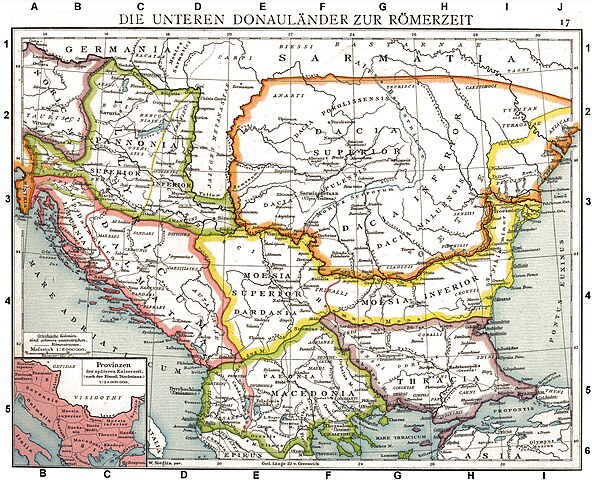
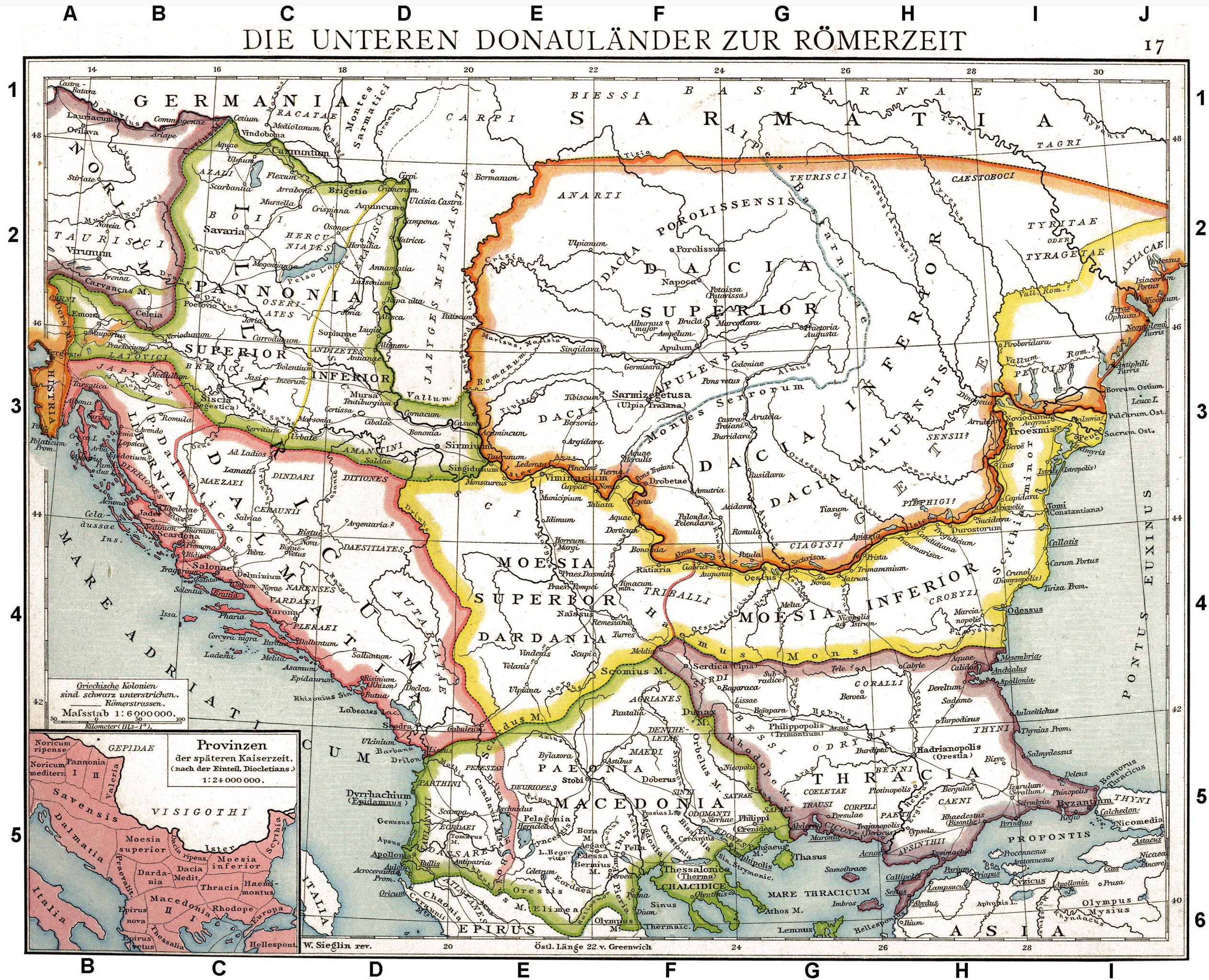
Deutsch: Die unteren Donauländer zur Römerzeit. Alte historische Karte aus Droysens Historischem Handatlas, 1886
English: The Roman provinces of the Lower Danube. Old historical map from Droysens Historical Atlas, 1886
Français : Provinces romaines d'Illyrie, de Macédoine, de Dacie, de Mésie, de Pannonie et de Thrace. Carte issue de l'Allgemeiner Historischer Handatlas de Gustav Droysen dirigé par Richard Andree, 1886. |
| 날짜 | |
| 출처 | Allgemeiner historischer Handatlas in 96 Karten mit erläuterndem Text Bielefeld, Velhagen & Klasing 1886, S. 16. |
| 저자 | Gustav Droysen (1838 — 1908) |
| 다른 버전 |
이 파일은 다음으로 파생됨: |
.jpg)
|
이 작품은 미국, 그리고 저작권 보호 기간이 저작자 사후 100년, 또는 그 이하인 모든 국가에서 퍼블릭 도메인입니다. | |
| 이 저작물은 모든 저작인접권을 포함한 저작권법하의 규제로부터 자유로운 것으로 확인되었습니다. | |
이 작품은 1929년 1월 1일 이전에 출판하였으므로 미국에서 퍼블릭 도메인입니다.
퍼블릭 도메인 작품을 공용에 올리기 위해서는 미국과 작품의 제작 국가에서 저작권이 만료되어야 합니다. 미국에서 제작된 작품이 아닐 경우, 제작 국가에서의 저작권 상태를 나타내는 저작권 태그를 반드시 추가로 부착해야 합니다.
|
| 주석 | 이 이미지에는 주석이 있습니다: 공용에서 주석을 보기 |
파일 역사
날짜/시간 링크를 클릭하면 해당 시간의 파일을 볼 수 있습니다.
| 날짜/시간 | 섬네일 | 크기 | 사용자 | 설명 | |
|---|---|---|---|---|---|
| 현재 | 2010년 9월 11일 (토) 19:06 | | 2,817 × 2,284 (1.41 MB) | DIREKTOR | Repairs |
| 2008년 5월 28일 (수) 04:22 |  | 2,817 × 2,284 (1.75 MB) | File Upload Bot (Magnus Manske) | {{BotMoveToCommons|en.wikipedia}} {{Information |Description={{en|Illyricum the Roman Province}} |Source=Transferred from [http://en.wikipedia.org en.wikipedia]; transfered to Commons by User:Koryakov Yuri using [http://tools.wikimedia.de/~magnus/com |
이 파일을 사용하는 문서
다음 문서 1개가 이 파일을 사용하고 있습니다:
이 파일을 사용하고 있는 모든 위키의 문서 목록
다음 위키에서 이 파일을 사용하고 있습니다:
- als.wikipedia.org에서 이 파일을 사용하고 있는 문서 목록
- an.wikipedia.org에서 이 파일을 사용하고 있는 문서 목록
- ar.wikipedia.org에서 이 파일을 사용하고 있는 문서 목록
- arz.wikipedia.org에서 이 파일을 사용하고 있는 문서 목록
- ast.wikipedia.org에서 이 파일을 사용하고 있는 문서 목록
- azb.wikipedia.org에서 이 파일을 사용하고 있는 문서 목록
- az.wikipedia.org에서 이 파일을 사용하고 있는 문서 목록
- be.wikipedia.org에서 이 파일을 사용하고 있는 문서 목록
- bg.wikipedia.org에서 이 파일을 사용하고 있는 문서 목록
- br.wikipedia.org에서 이 파일을 사용하고 있는 문서 목록
- bs.wikipedia.org에서 이 파일을 사용하고 있는 문서 목록
- ca.wikipedia.org에서 이 파일을 사용하고 있는 문서 목록
- da.wikipedia.org에서 이 파일을 사용하고 있는 문서 목록
- de.wikipedia.org에서 이 파일을 사용하고 있는 문서 목록
- Thrakien (Landschaft)
- Geschichte Kroatiens
- Geschichte Sloweniens
- Illyrien
- Geschichte Ungarns
- Dalmatia
- Moesia
- Geschichte von Bosnien und Herzegowina
- Arad (Rumänien)
- Diskussion:Pannonia (Provinz)
- Pannonischer Aufstand
- Benutzer:Devil m25/Spielwiese
- Donaulimes
- Balkanromanische Sprachen
- Moesia inferior
- Via Militaris (Balkan)
- Diskussion:Serben/Archiv
- Biosphärenreservat Donaudelta
- Geschichte der Stadt Perg
- Taurisker
- Machland
이 파일의 더 많은 사용 내역을 봅니다.