
파일:PeloponnesosMap.png

원본 파일 (330 × 653 픽셀, 파일 크기: 67 KB, MIME 종류: image/png)
This image was copied from wikipedia:en. The original description was:
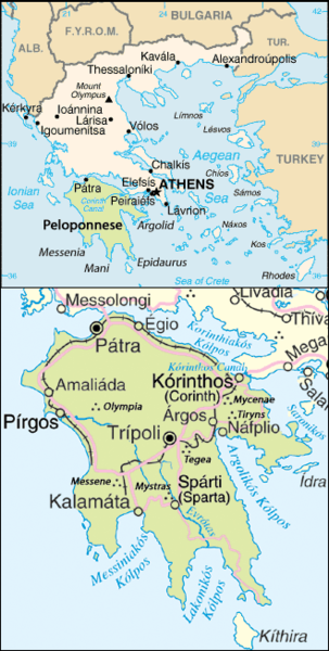
Map of the Peloponnesos.
Adapted from http://www.un.org/Depts/Cartographic/map/profile/greece.pdf
| 이 사진은 미국 중앙정보국(CIA)의 직원이 공무의 일환으로 제작하거나 촬영했습니다. 미국 정부가 제작한 사진이므로, 이 그림이나 미디어는 퍼블릭 도메인입니다.
|

|
| This image is a map derived from a United Nations map.
Unless stated otherwise, UN maps are to be considered in the public domain. This applies worldwide. UN maps are, in principle, open source material and you can use them in your work or for making your own map. UN requests however that you delete the UN name, logo and reference number upon any modification to the map. Content of your map will be your responsibility. You can state in your publication, if you wish, something like: based on UN map … (map name, map number, revision number and date). See: Geospatial Information Section. And: Geospatial, location data for a better world. |
 |
| date/time | username | edit summary |
|---|---|---|
| 22:08, 25 June 2005 | ChrisO | |
| 22:07, 25 June 2005 | ChrisO | |
| 22:03, 25 June 2005 | ChrisO | (Map of the <a href="/wiki/Peloponnesos" title="Peloponnesos">Peloponnesos</a>. Adapted from www.un.org/Depts/Cartographic/map/profile/greece.pdf {{PD-USGov-CIA}} {{UN-map}}) |
파일 역사
날짜/시간 링크를 클릭하면 해당 시간의 파일을 볼 수 있습니다.
| 날짜/시간 | 섬네일 | 크기 | 사용자 | 설명 | |
|---|---|---|---|---|---|
| 현재 | 2017년 10월 26일 (목) 07:26 | | 330 × 653 (67 KB) | Peritios | Reverted to version as of 23:41, 24 October 2017 (UTC) |
| 2017년 10월 25일 (수) 16:58 |  | 330 × 653 (152 KB) | MacedonianBoy | Reverted to version as of 08:59, 20 October 2013 (UTC) | |
| 2017년 10월 25일 (수) 08:41 |  | 330 × 653 (67 KB) | Peritios | Reverted to version as of 20:28, 8 October 2005 (UTC) | |
| 2014년 8월 4일 (월) 05:44 |  | 328 × 650 (51 KB) | Ras67 | cropped | |
| 2013년 10월 20일 (일) 17:59 |  | 330 × 653 (152 KB) | MacedonianBoy | name change | |
| 2005년 10월 9일 (일) 05:28 |  | 330 × 653 (67 KB) | ChongDae | This image was copied from wikipedia:en. The original description was: Map of the Peloponnesos. Adapted from http://www.un.org/Depts/Cartographic/map/profile/greece.pdf {{PD-USGov-CIA}} {{UN map}} {| border="1" ! date/time || username || edit sum |
이 파일을 사용하는 문서
다음 문서 1개가 이 파일을 사용하고 있습니다:
이 파일을 사용하고 있는 모든 위키의 문서 목록
다음 위키에서 이 파일을 사용하고 있습니다:
- af.wikipedia.org에서 이 파일을 사용하고 있는 문서 목록
- ar.wikipedia.org에서 이 파일을 사용하고 있는 문서 목록
- br.wikipedia.org에서 이 파일을 사용하고 있는 문서 목록
- cs.wikipedia.org에서 이 파일을 사용하고 있는 문서 목록
- en.wikipedia.org에서 이 파일을 사용하고 있는 문서 목록
- fa.wikipedia.org에서 이 파일을 사용하고 있는 문서 목록
- fo.wikipedia.org에서 이 파일을 사용하고 있는 문서 목록
- hi.wikipedia.org에서 이 파일을 사용하고 있는 문서 목록
- hu.wikipedia.org에서 이 파일을 사용하고 있는 문서 목록
- incubator.wikimedia.org에서 이 파일을 사용하고 있는 문서 목록
- ka.wikipedia.org에서 이 파일을 사용하고 있는 문서 목록
- lt.wikipedia.org에서 이 파일을 사용하고 있는 문서 목록
- nn.wikipedia.org에서 이 파일을 사용하고 있는 문서 목록
- no.wikipedia.org에서 이 파일을 사용하고 있는 문서 목록
- ro.wikipedia.org에서 이 파일을 사용하고 있는 문서 목록
- rue.wikipedia.org에서 이 파일을 사용하고 있는 문서 목록
- sh.wikipedia.org에서 이 파일을 사용하고 있는 문서 목록
- sl.wikipedia.org에서 이 파일을 사용하고 있는 문서 목록
- sr.wikipedia.org에서 이 파일을 사용하고 있는 문서 목록
- tr.wikipedia.org에서 이 파일을 사용하고 있는 문서 목록