
파일:Nishinoshima mlit1978.jpg
미리 보기 크기: 800 × 600 픽셀 다른 해상도: 320 × 240 픽셀 | 640 × 480 픽셀 | 1,024 × 768 픽셀
원본 파일 (1,024 × 768 픽셀, 파일 크기: 145 KB, MIME 종류: image/jpeg)
파일 설명
| 설명 |
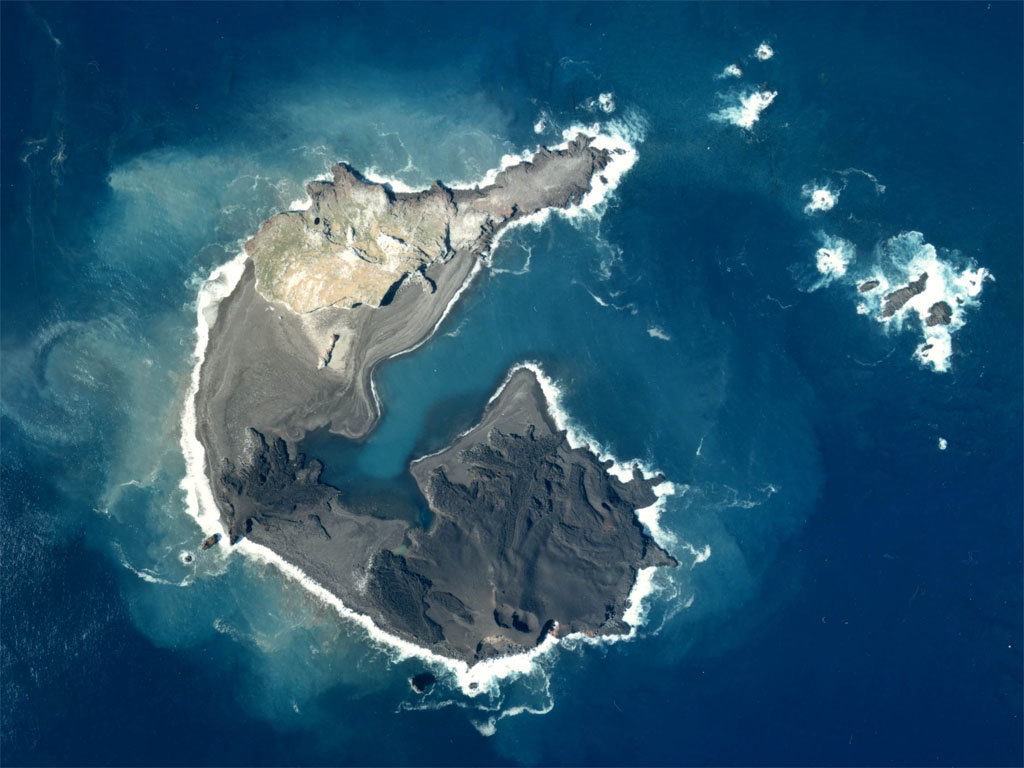
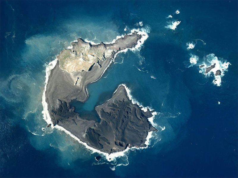
English: Aerial Photograph of Nishinoshima(Ogasawara Islands) at Japan in 1978. Last eruption is 1974.
日本語: 西之島および西之島新島の航空写真(1978年)。西之島は1973年に噴火し、新島を形成。新島はその後、西之島(写真上側)と接合した。 |
| 날짜 | |
| 출처 | http://w3land.mlit.go.jp/Air/photo400/78/ckt-78-4/c6/ckt-78-4_c6_2.jpg |
| 저자 | Tdk |
라이선스

|
이 파일의 저작권자인 일본 국토교통성은 저작권자를 명시하는 조건에 따라 누구에게나 어떤 목적으로든지 제한 없이 사용할 수 있도록 허용하였습니다. 재배포나 이차적 저작물 작성 및 상업적 이용 등이 허용됩니다. |
저작자표시:
Copyright © National Land Image Information (Color Aerial Photographs), Ministry of Land, Infrastructure, Transport and Tourism
|
 |
This image is copyrighted by the Ministry of Land, Infrastructure, Transport and Tourism of Japan. For terms of use, see the stipulation to use of National Land Information (in Japanese) and message from MLIT (in Japanese and English). When you display this image on an article, include the following phrase in the description: "Made based on National Land Image Information (Color Aerial Photographs), Ministry of Land, Infrastructure, Transport and Tourism".
|
파일 역사
날짜/시간 링크를 클릭하면 해당 시간의 파일을 볼 수 있습니다.
| 날짜/시간 | 섬네일 | 크기 | 사용자 | 설명 | |
|---|---|---|---|---|---|
| 현재 | 2008년 4월 28일 (월) 00:04 | | 1,024 × 768 (145 KB) | Tdk~commonswiki | {{Information |Description=en:Aerial Photograph of Nishinoshima(Ogasawara Islands)at Japan in 1978. Last eruption is 1974. ja:西之島および西之島新島の航空写真(1978年)。西之島は1973年に噴火し、新島を形成。新島はそ |
이 파일을 사용하는 문서
다음 문서 1개가 이 파일을 사용하고 있습니다:
이 파일을 사용하고 있는 모든 위키의 문서 목록
다음 위키에서 이 파일을 사용하고 있습니다:
- ar.wikipedia.org에서 이 파일을 사용하고 있는 문서 목록
- cs.wikipedia.org에서 이 파일을 사용하고 있는 문서 목록
- de.wikipedia.org에서 이 파일을 사용하고 있는 문서 목록
- en.wikipedia.org에서 이 파일을 사용하고 있는 문서 목록
- es.wikipedia.org에서 이 파일을 사용하고 있는 문서 목록
- ja.wikipedia.org에서 이 파일을 사용하고 있는 문서 목록
- nl.wikipedia.org에서 이 파일을 사용하고 있는 문서 목록
- pl.wikipedia.org에서 이 파일을 사용하고 있는 문서 목록
- ru.wikipedia.org에서 이 파일을 사용하고 있는 문서 목록
- sk.wikipedia.org에서 이 파일을 사용하고 있는 문서 목록
- uk.wikipedia.org에서 이 파일을 사용하고 있는 문서 목록
- zh.wikipedia.org에서 이 파일을 사용하고 있는 문서 목록