
파일:Kanawha Ohio confluence.jpg

미리 보기 크기: 751 × 600 픽셀 다른 해상도: 301 × 240 픽셀 | 601 × 480 픽셀 | 962 × 768 픽셀 | 1,280 × 1,022 픽셀 | 1,500 × 1,198 픽셀
원본 파일 (1,500 × 1,198 픽셀, 파일 크기: 724 KB, MIME 종류: image/jpeg)
파일 설명
| 설명 |
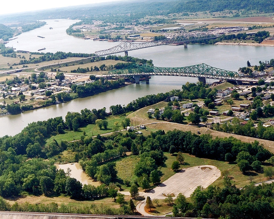
English: The confluence of the Kanawha and Ohio Rivers. The Kanawha River flows in from the left of the picture and joins the Ohio, meandering off in the distance. The town of Point Pleasant, West Virginia is in the foreground on the right. Henderson, West Virginia is on the left. The Ohio River forms the boundary between West Virginia and Ohio. The town of Gallipolis, Ohio lies in the far distance across the Ohio River. The view is to the west-southwest down the river. |
|||
| 날짜 | before 2007년 | |||
| 출처 |
U.S. Army Corps of Engineers Digital Visual Library Image page Image description page Digital Visual Library home page |
|||
| 저자 | Charles Johnson, U.S. Army Corps of Engineers | |||
| 저작권 (이 파일을 인용하기) |
|
|||
| 장소 | Point Pleasant, West Virginia, USA |
| 카메라 위치 | | 이 지역의 다른 사진을 보기: OpenStreetMap |
|---|
| 주석 | 이 이미지에는 주석이 있습니다: 공용에서 주석을 보기 |
파일 역사
날짜/시간 링크를 클릭하면 해당 시간의 파일을 볼 수 있습니다.
| 날짜/시간 | 섬네일 | 크기 | 사용자 | 설명 | |
|---|---|---|---|---|---|
| 현재 | 2007년 3월 23일 (금) 13:52 | | 1,500 × 1,198 (724 KB) | DanMS | {{Information | Description = {{en|The confluence of the Kanawha and Ohio Rivers. The Kanawha River flows in from the left of the picture and joins the Ohio, meandering off in the distance. The town of Point Pleasant, West Virginia is in the foreground |
이 파일을 사용하는 문서
다음 문서 1개가 이 파일을 사용하고 있습니다:
이 파일을 사용하고 있는 모든 위키의 문서 목록
다음 위키에서 이 파일을 사용하고 있습니다:
- ar.wikipedia.org에서 이 파일을 사용하고 있는 문서 목록
- arz.wikipedia.org에서 이 파일을 사용하고 있는 문서 목록
- ca.wikipedia.org에서 이 파일을 사용하고 있는 문서 목록
- ceb.wikipedia.org에서 이 파일을 사용하고 있는 문서 목록
- ce.wikipedia.org에서 이 파일을 사용하고 있는 문서 목록
- cy.wikipedia.org에서 이 파일을 사용하고 있는 문서 목록
- dag.wikipedia.org에서 이 파일을 사용하고 있는 문서 목록
- de.wikipedia.org에서 이 파일을 사용하고 있는 문서 목록
- en.wikipedia.org에서 이 파일을 사용하고 있는 문서 목록
- en.wikivoyage.org에서 이 파일을 사용하고 있는 문서 목록
- es.wikipedia.org에서 이 파일을 사용하고 있는 문서 목록
- eu.wikipedia.org에서 이 파일을 사용하고 있는 문서 목록
- fa.wikipedia.org에서 이 파일을 사용하고 있는 문서 목록
- fr.wikipedia.org에서 이 파일을 사용하고 있는 문서 목록
- hu.wikipedia.org에서 이 파일을 사용하고 있는 문서 목록
- it.wikipedia.org에서 이 파일을 사용하고 있는 문서 목록
- ja.wikipedia.org에서 이 파일을 사용하고 있는 문서 목록
- kw.wikipedia.org에서 이 파일을 사용하고 있는 문서 목록
- lld.wikipedia.org에서 이 파일을 사용하고 있는 문서 목록
- no.wikipedia.org에서 이 파일을 사용하고 있는 문서 목록
- pl.wikipedia.org에서 이 파일을 사용하고 있는 문서 목록
- pt.wikipedia.org에서 이 파일을 사용하고 있는 문서 목록
- ro.wikipedia.org에서 이 파일을 사용하고 있는 문서 목록
- ru.wikipedia.org에서 이 파일을 사용하고 있는 문서 목록
- sh.wikipedia.org에서 이 파일을 사용하고 있는 문서 목록
- simple.wikipedia.org에서 이 파일을 사용하고 있는 문서 목록
- sr.wikipedia.org에서 이 파일을 사용하고 있는 문서 목록
- tt.wikipedia.org에서 이 파일을 사용하고 있는 문서 목록
이 파일의 더 많은 사용 내역을 봅니다.