
파일:Fost areal image007.jpg
최대 해상도입니다.
Fost_areal_image007.jpg (375 × 249 픽셀, 파일 크기: 25 KB, MIME 종류: image/jpeg)
|
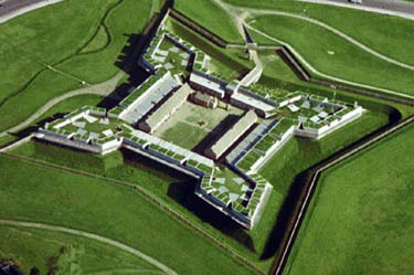
This is an image of a place or building that is listed on the National Register of Historic Places in the United States of America. Its reference number is 66000057. |
| 설명 | Areal view of Fort Stanwix National Monument, Rome, New York, USA | |||
| 출처 | Offical Website - http://www.nps.gov/fost/ | |||
| 저자 | NPS photo | |||
| 저작권 (이 파일을 인용하기) |
|
| 대상 위치 | | 이 지역의 다른 사진을 보기: OpenStreetMap |
|---|
파일 역사
날짜/시간 링크를 클릭하면 해당 시간의 파일을 볼 수 있습니다.
| 날짜/시간 | 섬네일 | 크기 | 사용자 | 설명 | |
|---|---|---|---|---|---|
| 현재 | 2007년 5월 25일 (금) 01:00 | | 375 × 249 (25 KB) | H-stt | {{Information |Description= Areal view of Fort Stanwix National Monument, Rome, New York, USA |Source= Offical Website - http://www.nps.gov/fost/ |Date= |Author= NPS photo |Permission= {{PD-USGov-NPS}} |other_versions= }} [[Category:Fort Stanwix National |
이 파일을 사용하는 문서
다음 문서 2개가 이 파일을 사용하고 있습니다:
이 파일을 사용하고 있는 모든 위키의 문서 목록
다음 위키에서 이 파일을 사용하고 있습니다:
- arz.wikipedia.org에서 이 파일을 사용하고 있는 문서 목록
- de.wikipedia.org에서 이 파일을 사용하고 있는 문서 목록
- en.wikipedia.org에서 이 파일을 사용하고 있는 문서 목록
- Upstate New York
- Fort Stanwix
- Wikipedia:Selected anniversaries/August 22
- National Register of Historic Places listings in New York
- National Register of Historic Places listings in Oneida County, New York
- List of national monuments of the United States
- Donald J. Mitchell
- John Stanwix
- Portal:United States/Anniversaries/August
- Portal:United States/Anniversaries/All
- List of National Historic Landmarks in New York
- List of museums in New York (state)
- List of National Park System areas in New York
- Siege of Fort Stanwix
- Portal:United States/Anniversaries/August/August 22
- Wikipedia:Main Page history/2012 August 22
- Wikipedia:Main Page history/2016 August 22
- Wikipedia:Main Page history/2022 August 22
- Wikipedia:Main Page history/2022 August 22b
- es.wikipedia.org에서 이 파일을 사용하고 있는 문서 목록
- eu.wikipedia.org에서 이 파일을 사용하고 있는 문서 목록
- fr.wikipedia.org에서 이 파일을 사용하고 있는 문서 목록
- he.wikipedia.org에서 이 파일을 사용하고 있는 문서 목록
- it.wikipedia.org에서 이 파일을 사용하고 있는 문서 목록
- ja.wikipedia.org에서 이 파일을 사용하고 있는 문서 목록
- no.wikipedia.org에서 이 파일을 사용하고 있는 문서 목록
- pl.wikipedia.org에서 이 파일을 사용하고 있는 문서 목록
- pl.wiktionary.org에서 이 파일을 사용하고 있는 문서 목록
- pt.wikipedia.org에서 이 파일을 사용하고 있는 문서 목록
- ru.wikipedia.org에서 이 파일을 사용하고 있는 문서 목록
- simple.wikipedia.org에서 이 파일을 사용하고 있는 문서 목록
- sv.wikipedia.org에서 이 파일을 사용하고 있는 문서 목록
- uk.wikipedia.org에서 이 파일을 사용하고 있는 문서 목록
- uz.wikipedia.org에서 이 파일을 사용하고 있는 문서 목록
- vi.wikipedia.org에서 이 파일을 사용하고 있는 문서 목록
- www.wikidata.org에서 이 파일을 사용하고 있는 문서 목록