
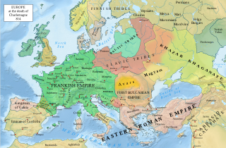
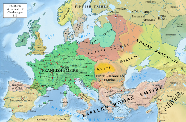
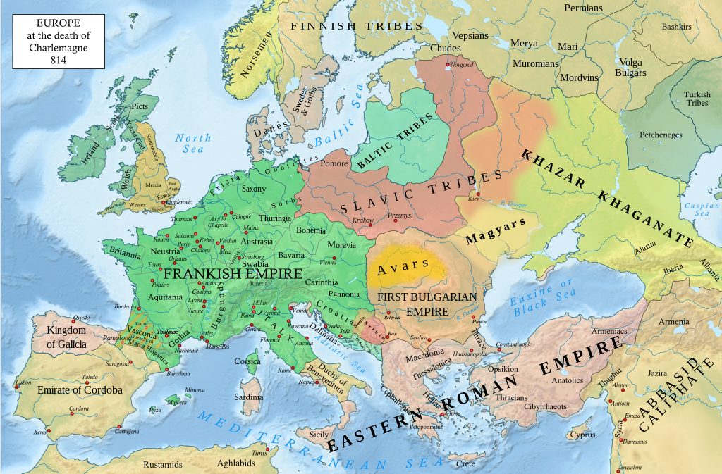
파일:Europe 814.svg

원본 파일 (SVG 파일, 실제 크기 1,399 × 919 픽셀, 파일 크기: 3.4 MB)
파일 설명
| 설명 |
English: An svg version of File:Europe 814.jpg with corrections.
List of corrections:
|
| 날짜 | |
| 출처 | "The Public Schools Historical Atlas" by Charles Colbeck. Longmans, Green; New York; London; Bombay. 1905. |
| 저자 | Hel-hama |
| 다른 버전 |
|


_en.png)
.png)
.jpg)
라이선스
- 이용자는 다음의 권리를 갖습니다:
- 공유 및 이용 – 저작물의 복제, 배포, 전시, 공연 및 공중송신
- 재창작 – 저작물의 개작, 수정, 2차적저작물 창작
- 다음과 같은 조건을 따라야 합니다:
- 저작자표시 – 적절한 저작자 표시를 제공하고, 라이센스에 대한 링크를 제공하고, 변경사항이 있는지를 표시해야 합니다. 당신은 합리적인 방식으로 표시할 수 있지만, 어떤 방식으로든 사용권 허가자가 당신 또는 당신의 사용을 지지하는 방식으로 표시할 수 없습니다.
- 동일조건변경허락 – 만약 당신이 이 저작물을 리믹스 또는 변형하거나 이 저작물을 기반으로 제작하는 경우, 당신은 당신의 기여물을 원저작물과 동일하거나 호환 가능한 라이선스에 따라 배포하여야 합니다.
This media file is in the public domain in the United States. This applies to U.S. works where the copyright has expired, often because its first publication occurred prior to January 1, 1929, and if not then due to lack of notice or renewal. See this page for further explanation.
|
 | |
 |
This image might not be in the public domain outside of the United States; this especially applies in the countries and areas that do not apply the rule of the shorter term for US works, such as Canada, Mainland China (not Hong Kong or Macao), Germany, Mexico, and Switzerland. The creator and year of publication are essential information and must be provided. See Wikipedia:Public domain and Wikipedia:Copyrights for more details.
|
.svg)
|
This file is licensed under the Open Government Licence version 1.0 (OGL v1.0).
|
|---|---|
|
You are free to:
See the Open Government Licence page on Meta-Wiki for more information.
|
This work is in the public domain in India because its term of copyright has expired.
The Indian Copyright Act applies in India to works first published in India. According to the Indian Copyright Act, 1957, as amended up to Act No. 27 of 2012 (Chapter V, Section 25):
|
 |
파일 역사
날짜/시간 링크를 클릭하면 해당 시간의 파일을 볼 수 있습니다.
| 날짜/시간 | 섬네일 | 크기 | 사용자 | 설명 | |
|---|---|---|---|---|---|
| 현재 | 2023년 1월 9일 (월) 05:05 | | 1,399 × 919 (3.4 MB) | Miki Filigranski | correction of Bosnian border, which was a separate land according to modern scholarship, contested but never completelly under Serbian or Croatian control |
| 2022년 11월 30일 (수) 06:32 |  | 1,399 × 919 (3.39 MB) | Gyalu22 | Added Avar ethnic territory, see Bulgarians_and_Slavs_VI-VII_century.png. Also extended Magyar ethnic territory to Bessarabia | |
| 2022년 11월 1일 (화) 19:26 |  | 1,399 × 919 (3.38 MB) | Miki Filigranski | Reverted to version as of 07:20, 31 July 2022 (UTC) | |
| 2022년 8월 3일 (수) 13:47 |  | 1,399 × 919 (3.38 MB) | Bernd21t | (편집 요약 삭제됨) | |
| 2022년 7월 31일 (일) 16:20 |  | 1,399 × 919 (3.38 MB) | Miki Filigranski | Reverted to version as of 16:51, 27 March 2022 (UTC) | |
| 2022년 7월 18일 (월) 14:13 |  | 1,399 × 919 (3.38 MB) | Ionelen | Reverted to version as of 19:41, 13 April 2022 (UTC) | |
| 2022년 7월 12일 (화) 16:41 |  | 1,399 × 919 (3.38 MB) | Ahmet Q. | Reverted to version as of 16:51, 27 March 2022 (UTC) | |
| 2022년 4월 14일 (목) 04:41 |  | 1,399 × 919 (3.38 MB) | Wojsław12 | Reverted to version as of 11:43, 14 January 2022 (UTC) | |
| 2022년 3월 28일 (월) 01:51 |  | 1,399 × 919 (3.38 MB) | Silverije | Reverted to version as of 12:43, 1 June 2021 (UTC) | |
| 2022년 1월 14일 (금) 20:43 |  | 1,399 × 919 (3.38 MB) | TómasdeAquino2 | Corrected POV issues of blocked sock of Crovata Miki Filigranski |
이 파일을 사용하는 문서
이 파일을 사용하고 있는 모든 위키의 문서 목록
다음 위키에서 이 파일을 사용하고 있습니다:
- af.wikipedia.org에서 이 파일을 사용하고 있는 문서 목록
- ar.wikipedia.org에서 이 파일을 사용하고 있는 문서 목록
- arz.wikipedia.org에서 이 파일을 사용하고 있는 문서 목록
- bg.wikipedia.org에서 이 파일을 사용하고 있는 문서 목록
- bn.wikipedia.org에서 이 파일을 사용하고 있는 문서 목록
- ca.wikipedia.org에서 이 파일을 사용하고 있는 문서 목록
- cs.wikipedia.org에서 이 파일을 사용하고 있는 문서 목록
- cy.wikipedia.org에서 이 파일을 사용하고 있는 문서 목록
- de.wikipedia.org에서 이 파일을 사용하고 있는 문서 목록
- el.wikipedia.org에서 이 파일을 사용하고 있는 문서 목록
- en.wikipedia.org에서 이 파일을 사용하고 있는 문서 목록
- Charlemagne
- History of Europe
- Vikings
- 814
- History of Estonia
- Bulgars
- Principality of Serbia (early medieval)
- Saare County
- Early Middle Ages
- Kvenland
- Askold and Dir
- Duchy of Benevento
- Portal:Estonia
- Franks
- Višeslav of Serbia
- History of Christian thought on persecution and tolerance
- Borna (duke)
- Vlastimir
- Arab–Khazar wars
- Duchy of Gascony
- Muslim conquest of Sicily
- Prosigoj
- Rus' people
- Early Slavs
- Radoslav of Serbia
- Barbarian kingdoms
- Agriculture in the Middle Ages
- Gersuinda
- User:Falcaorib
- en.wikibooks.org에서 이 파일을 사용하고 있는 문서 목록
이 파일의 더 많은 사용 내역을 봅니다.