
파일:Earthquake wave paths.png

Earthquake_wave_paths.png (300 × 250 픽셀, 파일 크기: 13 KB, MIME 종류: image/png)

|
이 그림은 벡터 그래픽 버전(SVG)이 있습니다. 래스터(비트맵) 그림 대신 벡터 그래픽 그림을 사용하는 것이 좋습니다.
File:Earthquake wave paths.png → File:Earthquake wave paths.svg
|
 |
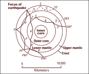
Cross section of the whole Earth, showing the complexity of paths of earthquake waves. The paths curve because the different rock types found at different depths change the speed at which the waves travel. Solid lines marked P are compressional waves; dashed lines marked S are shear waves. S waves do not travel through the core but may be converted to compressional waves (marked K) on entering the core (PKP, SKS). Waves may be reflected at the surface (PP, PPP, SS).
Seismographs detect the various types of waves. Analysis of such records reveals structures within the Earth.
Source: http://pubs.usgs.gov/gip/interior/fig2.gif ; original upload in english wikipedia, 15 April 2005 by SEWilco
|
|
기존 올리기 기록
| 날짜/시간 | 크기 | 사용자 | 설명 |
|---|---|---|---|
| 2005년 9월 4일, 12:53:16 | 300 × 250 (13208 bytes) | Saperaud (토론 · 기여) | Cross section of the whole [[Earth]], showing the complexity of paths of [[earthquake]] waves. The paths curve because the different rock types found at different depths change the speed at which the waves travel. Solid lines marked P are compressional wa |
파일 역사
날짜/시간 링크를 클릭하면 해당 시간의 파일을 볼 수 있습니다.
| 날짜/시간 | 섬네일 | 크기 | 사용자 | 설명 | |
|---|---|---|---|---|---|
| 현재 | 2015년 1월 7일 (수) 01:54 | | 300 × 250 (13 KB) | GifTagger | Bot: Converting file to superior PNG file. (Source: Earthquake_wave_paths.gif). This GIF was problematic due to non-greyscale color table. |
이 파일을 사용하는 문서
이 파일을 사용하는 문서가 없습니다.
이 파일을 사용하고 있는 모든 위키의 문서 목록
다음 위키에서 이 파일을 사용하고 있습니다:
- ary.wikipedia.org에서 이 파일을 사용하고 있는 문서 목록
- cs.wikipedia.org에서 이 파일을 사용하고 있는 문서 목록
- de.wikipedia.org에서 이 파일을 사용하고 있는 문서 목록
- en.wikipedia.org에서 이 파일을 사용하고 있는 문서 목록
- es.wikipedia.org에서 이 파일을 사용하고 있는 문서 목록
- fi.wikipedia.org에서 이 파일을 사용하고 있는 문서 목록
- fr.wikipedia.org에서 이 파일을 사용하고 있는 문서 목록
- it.wikipedia.org에서 이 파일을 사용하고 있는 문서 목록
- nds.wikipedia.org에서 이 파일을 사용하고 있는 문서 목록
- sk.wikipedia.org에서 이 파일을 사용하고 있는 문서 목록
- Stavba Zeme
- Gutenbergova diskontinuita
- Portál:Vedy o Zemi
- Portál:Vedy o Zemi/Odporúčané články
- Portál:Vedy o Zemi/Odporúčaný článok/15 2007
- Portál:Vedy o Zemi/Odporúčaný článok/42 2007
- Portál:Vedy o Zemi/Odporúčané články/2007
- Portál:Vedy o Zemi/Odporúčaný článok/15
- Portál:Vedy o Zemi/Odporúčaný článok/53
- tr.wikipedia.org에서 이 파일을 사용하고 있는 문서 목록
- vi.wikipedia.org에서 이 파일을 사용하고 있는 문서 목록
- zh-yue.wikipedia.org에서 이 파일을 사용하고 있는 문서 목록
- zh.wikipedia.org에서 이 파일을 사용하고 있는 문서 목록