
파일:Arthur 2008 track.png

미리 보기 크기: 800 × 495 픽셀 다른 해상도: 320 × 198 픽셀 | 640 × 396 픽셀 | 1,024 × 633 픽셀 | 1,280 × 791 픽셀 | 2,700 × 1,669 픽셀
원본 파일 (2,700 × 1,669 픽셀, 파일 크기: 2.92 MB, MIME 종류: image/png)
파일 설명
| 설명 |
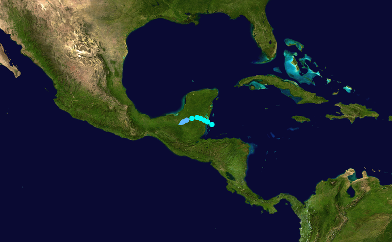
English: Track map of Tropical Storm Arthur of the 2008 Atlantic hurricane season. The points show the location of the storm at 6-hour intervals. The colour represents the storm's maximum sustained wind speeds as classified in the (see below), and the shape of the data points represent the nature of the storm, according to the legend below. 열대저기압 (≤38 mph, ≤62 km/h)
열대폭풍 (39–73 mph, 63–118 km/h)
1등급 (74–95 mph, 119–153 km/h)
2등급 (96–110 mph, 154–177 km/h)
3등급 (111–129 mph, 178–208 km/h)
4등급 (130–156 mph, 209–251 km/h)
5등급 (≥157 mph, ≥252 km/h)
알 수 없음
|
||
| 날짜 | 2008-05-31–2008-06-02 | ||
| 출처 | Created by Supportstorm using Wikipedia:WikiProject Tropical cyclones/Tracks. The background image is from NASA. Tracking data is from the National Hurricane Center[1]. | ||
| 저자 | Supportstorm | ||
| Source code | Track map data table, if present below, is in HURDAT2 or ATCF format. See format details in [2] and [3], respectively.
|
라이선스
| 이 작품은 저작자인 Supportstorm에 의해 퍼블릭 도메인으로 공개된 작품입니다. 이 공개 선언은 전 세계적으로 유효합니다. 만약 저작권의 포기가 법률적으로 가능하지 않은 경우, Supportstorm은 이 작품을 법적으로 허용되는 한도 내에서 누구나 자유롭게 어떤 목적으로도 제한 없이 사용할 수 있도록 허용합니다. |
파일 역사
날짜/시간 링크를 클릭하면 해당 시간의 파일을 볼 수 있습니다.
| 날짜/시간 | 섬네일 | 크기 | 사용자 | 설명 | |
|---|---|---|---|---|---|
| 현재 | 2019년 8월 18일 (일) 16:32 | | 2,700 × 1,669 (2.92 MB) | Supportstorm | Correction from HURDAT |
| 2009년 3월 14일 (토) 05:58 |  | 1,024 × 633 (477 KB) | Potapych | fix a slight error | |
| 2008년 12월 18일 (목) 07:54 |  | 1,024 × 633 (497 KB) | Potapych | generated with track program | |
| 2008년 7월 30일 (수) 10:06 |  | 707 × 397 (261 KB) | CWY2190 | New image with smaller shapes. | |
| 2008년 7월 30일 (수) 09:39 |  | 800 × 487 (334 KB) | CWY2190 | Arthur best track | |
| 2008년 7월 10일 (목) 08:05 |  | 1,000 × 629 (457 KB) | CWY2190 | adding four low pressure areas | |
| 2008년 7월 10일 (목) 07:30 |  | 1,000 × 629 (457 KB) | CWY2190 | Track map of Tropical Storm Arthur of the 2008 Atlantic hurricane season. The background image is from {{w|NASA}}. Tracking data is from the [ftp://ftp.tpc.ncep.noaa.gov/atcf/tcweb/invest_al012008.invest|Natio | |
| 2008년 7월 10일 (목) 07:30 |  | 1,000 × 629 (457 KB) | CWY2190 | Track map of Tropical Storm Arthur of the 2008 Atlantic hurricane season. The background image is from {{w|NASA}}. Tracking data is from the [ftp://ftp.tpc.ncep.noaa.gov/atcf/tcweb/invest_al012008.invest|Natio | |
| 2008년 6월 3일 (화) 03:43 |  | 1,024 × 636 (25 KB) | Ramisses | {{Information |Description={{en|1=Tropical Storm Arthur (2008) track map}} |Source=Own work by uploader |Author=Ramisses |Date=2008-06-02 |Permission={{PD-self}} |other_versions= }} {{ImageUpload|full}} [[Category:Tropical Storm Arthur |
이 파일을 사용하는 문서
다음 문서 4개가 이 파일을 사용하고 있습니다:
이 파일을 사용하고 있는 모든 위키의 문서 목록
다음 위키에서 이 파일을 사용하고 있습니다:
- cs.wikipedia.org에서 이 파일을 사용하고 있는 문서 목록
- de.wikipedia.org에서 이 파일을 사용하고 있는 문서 목록
- en.wikipedia.org에서 이 파일을 사용하고 있는 문서 목록
- es.wikipedia.org에서 이 파일을 사용하고 있는 문서 목록
- eu.wikipedia.org에서 이 파일을 사용하고 있는 문서 목록
- fr.wikipedia.org에서 이 파일을 사용하고 있는 문서 목록
- nl.wikipedia.org에서 이 파일을 사용하고 있는 문서 목록
- no.wikipedia.org에서 이 파일을 사용하고 있는 문서 목록
- pt.wikipedia.org에서 이 파일을 사용하고 있는 문서 목록
- ru.wikipedia.org에서 이 파일을 사용하고 있는 문서 목록
- simple.wikipedia.org에서 이 파일을 사용하고 있는 문서 목록
- sv.wikipedia.org에서 이 파일을 사용하고 있는 문서 목록
- uk.wikipedia.org에서 이 파일을 사용하고 있는 문서 목록
- www.wikidata.org에서 이 파일을 사용하고 있는 문서 목록
- zh.wikipedia.org에서 이 파일을 사용하고 있는 문서 목록