
파일:Adıyaman districts.png
미리 보기 크기: 776 × 600 픽셀 다른 해상도: 311 × 240 픽셀 | 621 × 480 픽셀 | 994 × 768 픽셀 | 1,056 × 816 픽셀
원본 파일 (1,056 × 816 픽셀, 파일 크기: 20 KB, MIME 종류: image/png)

|
This map has been uploaded by Electionworld from en.wikipedia.org to enable the |
파일 설명
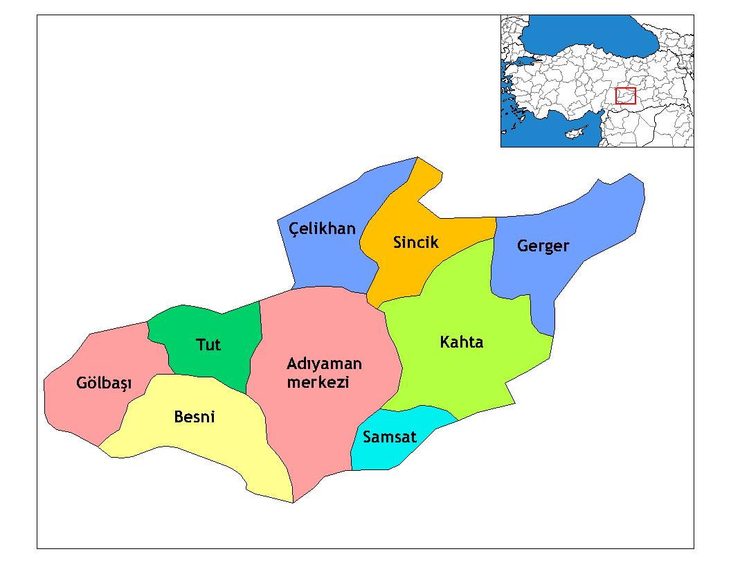
Map of the districts of Adıyaman province in Turkey. Created by Rarelibra 22:15, 13 November 2006 (UTC) for public domain use, using MapInfo Professional v8.5 and various mapping resources. Edited by One Homo Sapiens Corrected text where İ,Ş,ı,ğ,or ş occurs in name. Source: [statoids-com]. Increased font size and enhanced color differences among adjacent districts.

|
이 그림 파일은 벡터 SVG 형식으로 다시 만들어야 합니다. SVG의 장점에 대해서는 여기(영어)를 참고해 주십시오. 만약 이 그림의 SVG 버전이 이미 존재한다면 이 틀을 {{vector version available|새 파일 이름.svg}}으로 대체해 주십시오.
|
라이선스
| 이 작품은 저작자인 Rarelibra에 의해 퍼블릭 도메인으로 공개된 작품입니다. 이 공개 선언은 전 세계적으로 유효합니다. 만약 저작권의 포기가 법률적으로 가능하지 않은 경우, |
Renamed by Denizz
파일 역사
날짜/시간 링크를 클릭하면 해당 시간의 파일을 볼 수 있습니다.
| 날짜/시간 | 섬네일 | 크기 | 사용자 | 설명 | |
|---|---|---|---|---|---|
| 현재 | 2008년 12월 29일 (월) 04:54 | | 1,056 × 816 (20 KB) | One Homo Sapiens | Corrected text where İ,Ş,ı,ğ,or ş occurs in name. Source: [statoids-com]. Increased font size and enhanced color differences among adjacent districts. |
| 2007년 3월 31일 (토) 14:14 |  | 1,056 × 816 (25 KB) | Denizz~commonswiki | {{ew|en|Rarelibra}} == Summary == Map of the districts of Adana province in Turkey. Created by Rarelibra 22:15, 13 November 2006 (UTC) for public domain use, using MapInfo Professional v8.5 and various mapping resources. == Licensing = |
이 파일을 사용하는 문서
다음 문서 1개가 이 파일을 사용하고 있습니다:
이 파일을 사용하고 있는 모든 위키의 문서 목록
다음 위키에서 이 파일을 사용하고 있습니다:
- ast.wikipedia.org에서 이 파일을 사용하고 있는 문서 목록
- azb.wikipedia.org에서 이 파일을 사용하고 있는 문서 목록
- az.wikipedia.org에서 이 파일을 사용하고 있는 문서 목록
- bn.wikipedia.org에서 이 파일을 사용하고 있는 문서 목록
- br.wikipedia.org에서 이 파일을 사용하고 있는 문서 목록
- ca.wikipedia.org에서 이 파일을 사용하고 있는 문서 목록
- cs.wikipedia.org에서 이 파일을 사용하고 있는 문서 목록
- de.wikipedia.org에서 이 파일을 사용하고 있는 문서 목록
- diq.wikipedia.org에서 이 파일을 사용하고 있는 문서 목록
- Aldûş
- Eskiköy
- Sarıyaprak
- Üçgöz
- Akpınar, Bêsni
- Aktepe
- Akyazı, Bêsni
- Alıçlı
- Alişar
- Aşağıçöplü
- Aşağısöğütlü
- Başlı
- Bereketli
- Beşkoz
- Çaykaya
- Çamuşçu
- Çamlıca
- Burunçayır
- Boncuk
- Beşyol
- Karagüveç
- Kuzevleri
- Oyratlı
- Tokar
- Qezê Tırkiya
- Çilboğaz, Bêsni
- Geçitli, Bêsni
- Kızılin, Bêsni
- Yelbastı, Bêsni
- Uzunkuyu, Bêsni
- Konuklu, Bêsni
이 파일의 더 많은 사용 내역을 봅니다.