
파일:20080317-JPN140-Sumida-Tsukiji-more.jpg
미리 보기 크기: 800 × 299 픽셀 다른 해상도: 320 × 120 픽셀 | 640 × 239 픽셀 | 1,024 × 383 픽셀 | 1,280 × 479 픽셀 | 2,560 × 958 픽셀 | 5,620 × 2,103 픽셀
원본 파일 (5,620 × 2,103 픽셀, 파일 크기: 7.01 MB, MIME 종류: image/jpeg)
파일 설명
| 설명 |
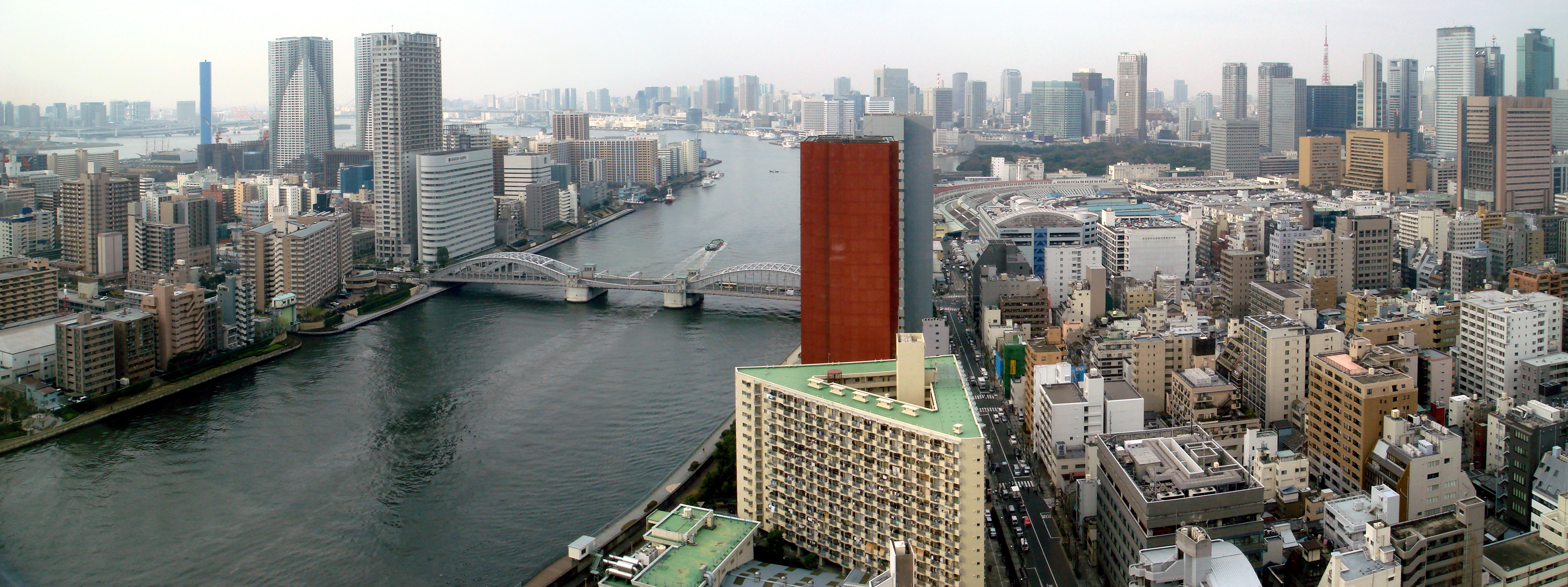
English: Facing southwest: The Sumida River enters the Tokyo Port region of Tokyo Bay. The bridge visible is the Kachidoki Bridge (Kachidoki Ohashi). To the left (east) of the river is the lower portion of Tsukishima (island neighborhood), Chūō Ward, Tokyo: the two twin towers on the island are The Tokyo Towers, a condominium complex. Further to the left (east) is the blue smokestack of the Chuo Incineration Plant on Harumi Island. On the top left horizon is Odaiba. To the right (west) is the Tsukiji neighborhood, with the famous Tsukiji fish market visible to the right of and behind the reddish building (it is the shape of a quarter-circle). The large garden behind the market are the Hamarikyu Gardens. The coffee-colored building to the right of Tsujkiji market (with the slanting bottom) is the headquarters of the Asahi Shimbun. The collection of modern skyscrapers immediately behind the Asahi Shimbun make up the Shiodome area; and behind those towers is the top of Tokyo Tower. |
| 날짜 | |
| 출처 | 자작 |
| 저자 | Bobak Ha'Eri |
| 저작권 (이 파일을 인용하기) |
CC-By-SA-3.0 |
Photo taken by Bobak Ha'Eri, on March 17, 2008. Please observe license and properly cite in use outside Wikipedia.
라이선스
나는 아래 작품의 저작권자로서, 이 저작물을 다음과 같은 라이선스로 배포합니다:
이 파일은 크리에이티브 커먼즈 저작자표시 3.0 Unported 라이선스로 배포됩니다.
- 이용자는 다음의 권리를 갖습니다:
- 공유 및 이용 – 저작물의 복제, 배포, 전시, 공연 및 공중송신
- 재창작 – 저작물의 개작, 수정, 2차적저작물 창작
- 다음과 같은 조건을 따라야 합니다:
- 저작자표시 – 적절한 저작자 표시를 제공하고, 라이센스에 대한 링크를 제공하고, 변경사항이 있는지를 표시해야 합니다. 당신은 합리적인 방식으로 표시할 수 있지만, 어떤 방식으로든 사용권 허가자가 당신 또는 당신의 사용을 지지하는 방식으로 표시할 수 없습니다.
파일 역사
날짜/시간 링크를 클릭하면 해당 시간의 파일을 볼 수 있습니다.
| 날짜/시간 | 섬네일 | 크기 | 사용자 | 설명 | |
|---|---|---|---|---|---|
| 현재 | 2008년 7월 1일 (화) 09:16 | 5,620 × 2,103 (7.01 MB) | Bobak | {{Information |Description = {{en|Facing southwest: The '''Sumida River''' enters the Tokyo Port region of Tokyo Bay. The bridge visible is the Kachidoki Bridge (Kachidoki Ohashi). To the left (east) of the river i |
이 파일을 사용하는 문서
다음 문서 1개가 이 파일을 사용하고 있습니다:
이 파일을 사용하고 있는 모든 위키의 문서 목록
다음 위키에서 이 파일을 사용하고 있습니다:
- ar.wikipedia.org에서 이 파일을 사용하고 있는 문서 목록
- bn.wikipedia.org에서 이 파일을 사용하고 있는 문서 목록
- ceb.wikipedia.org에서 이 파일을 사용하고 있는 문서 목록
- de.wikipedia.org에서 이 파일을 사용하고 있는 문서 목록
- en.wikipedia.org에서 이 파일을 사용하고 있는 문서 목록
- eo.wikipedia.org에서 이 파일을 사용하고 있는 문서 목록
- es.wikipedia.org에서 이 파일을 사용하고 있는 문서 목록
- eu.wikipedia.org에서 이 파일을 사용하고 있는 문서 목록
- fr.wikipedia.org에서 이 파일을 사용하고 있는 문서 목록
- hu.wikipedia.org에서 이 파일을 사용하고 있는 문서 목록
- ja.wikipedia.org에서 이 파일을 사용하고 있는 문서 목록
- nl.wikipedia.org에서 이 파일을 사용하고 있는 문서 목록
- no.wikipedia.org에서 이 파일을 사용하고 있는 문서 목록
- pl.wikipedia.org에서 이 파일을 사용하고 있는 문서 목록
- sl.wikipedia.org에서 이 파일을 사용하고 있는 문서 목록
- tr.wikipedia.org에서 이 파일을 사용하고 있는 문서 목록
- www.wikidata.org에서 이 파일을 사용하고 있는 문서 목록
- zh.wikipedia.org에서 이 파일을 사용하고 있는 문서 목록