
파일:Reelfoot Rift diagram from USGS en.svg

SVG 파일의 PNG 형식의 미리보기 크기: 426 × 287 픽셀. 다른 해상도: 320 × 216 픽셀 | 640 × 431 픽셀 | 1,024 × 690 픽셀 | 1,280 × 862 픽셀 | 2,560 × 1,725 픽셀
원본 파일 (SVG 파일, 실제 크기 426 × 287 픽셀, 파일 크기: 606 KB)
파일 설명
| 설명 |
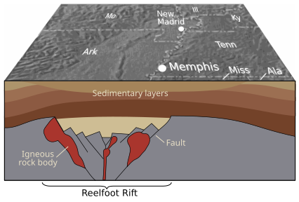
English: Geology of the Reelfoot Rift. From the source: "Geologic structures related to earthquakes in the central Mississippi Valley region have been deeply buried over hundreds of millions of years by thick layers of sediment. Geophysical studies have revealed a major buried northeast-trending feature known as the Reelfoot Rift (here shown in cross section), which formed more than 500 million years ago when powerful geologic forces began to pull the Earth's crust apart. Most quakes in the central Mississippi Valley appear to be related to the major faults and large bodies of igneous rock within the rift." Thomas G. Hildenbrand,Victoria E. Langenheim, Eugene Schweig, Peter H. Stauffer, and James W. Hendley II (USGS) |
| 날짜 | Published in 1996 |
| 출처 | "Uncovering Hidden Hazards in the Mississippi Valley" - USGS Fact Sheet, 1996, webpage archived from the original (dead link). Source is now live at this link as of 2021. |
| 저자 | USGS |
| 다른 버전 |
  |
라이선스
|
|
파일 역사
날짜/시간 링크를 클릭하면 해당 시간의 파일을 볼 수 있습니다.
| 날짜/시간 | 섬네일 | 크기 | 사용자 | 설명 | |
|---|---|---|---|---|---|
| 현재 | 2010년 1월 15일 (금) 14:26 | | 426 × 287 (606 KB) | Kbh3rd | {{Information |Description={{en|1=Geology of the Reelfoot Rift. From the source: "Geologic structures related to earthquakes in the central Mississippi Valley region have been deeply buried over hundreds of millions of years by thick layers of sediment. |
이 파일을 사용하는 문서
다음 문서 1개가 이 파일을 사용하고 있습니다:
이 파일을 사용하고 있는 모든 위키의 문서 목록
다음 위키에서 이 파일을 사용하고 있습니다:
- en.wikipedia.org에서 이 파일을 사용하고 있는 문서 목록
- es.wikipedia.org에서 이 파일을 사용하고 있는 문서 목록
- eu.wikipedia.org에서 이 파일을 사용하고 있는 문서 목록
- fr.wikipedia.org에서 이 파일을 사용하고 있는 문서 목록
- he.wikipedia.org에서 이 파일을 사용하고 있는 문서 목록
- ja.wikipedia.org에서 이 파일을 사용하고 있는 문서 목록
- pl.wikipedia.org에서 이 파일을 사용하고 있는 문서 목록
- pt.wikipedia.org에서 이 파일을 사용하고 있는 문서 목록